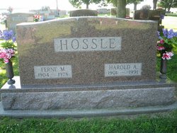
Harold Alexander Hossle
| Birth | : | 28 Feb 1901 Montgomery County, Iowa, USA |
| Death | : | 9 May 1991 Omaha, Douglas County, Nebraska, USA |
| Burial | : | Allerton Cemetery, Allerton, Metropolitan Borough of Liverpool, England |
| Coordinate | : | 53.3615646, -2.8844030 |
| Plot | : | 3rd Addition #147 |
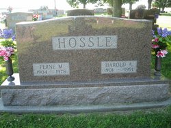
| Description | : | Harold Alexander Hossle, the son of John and Eliza (Trumbauer) Hossle, was born February 28, 1901 in Montgomery County, Iowa. He passed away after a short illness at the Bergan-Mercy Hospital, Omaha, Nebraska on May 9, 1991 at the age of 90 years, 2 months, and 11 days. He was united to Ferne M. Smith on March 25, 1928 at Emerson, Iowa. She passed away on April 4, 1978. He was raised north of Stanton, Iowa and moved to a farm near Emerson, Iowa in 1911 at the age of 10. He was a farmer... Read More |
frequently asked questions (FAQ):
-
Where is Harold Alexander Hossle's memorial?
Harold Alexander Hossle's memorial is located at: Allerton Cemetery, Allerton, Metropolitan Borough of Liverpool, England.
-
When did Harold Alexander Hossle death?
Harold Alexander Hossle death on 9 May 1991 in Omaha, Douglas County, Nebraska, USA
-
Where are the coordinates of the Harold Alexander Hossle's memorial?
Latitude: 53.3615646
Longitude: -2.8844030
Family Members:
Parent
Spouse
Siblings
Children
Flowers:
Nearby Cemetories:
1. Allerton Cemetery
Allerton, Metropolitan Borough of Liverpool, England
Coordinate: 53.3615646, -2.8844030
2. Saint Michael's Church
Garston, Metropolitan Borough of Liverpool, England
Coordinate: 53.3518400, -2.8973800
3. St. Mary's Churchyard
Woolton, Metropolitan Borough of Liverpool, England
Coordinate: 53.3750550, -2.8703760
4. St Austin's Churchyard
Grassendale, Metropolitan Borough of Liverpool, England
Coordinate: 53.3614552, -2.9124587
5. St. Peter's Churchyard
Woolton, Metropolitan Borough of Liverpool, England
Coordinate: 53.3759310, -2.8693390
6. Calderstones Park
Liverpool, Metropolitan Borough of Liverpool, England
Coordinate: 53.3817419, -2.8956218
7. All Hallows Churchyard
Mossley Hill, Metropolitan Borough of Liverpool, England
Coordinate: 53.3808740, -2.9039930
8. All Saints Churchyard
Speke, Metropolitan Borough of Liverpool, England
Coordinate: 53.3439300, -2.8582400
9. St Matthew & St James Churchyard
Mossley Hill, Metropolitan Borough of Liverpool, England
Coordinate: 53.3764200, -2.9204740
10. St. Anne's Churchyard
Aigburth, Metropolitan Borough of Liverpool, England
Coordinate: 53.3695480, -2.9305760
11. All Saints Churchyard
Childwall, Metropolitan Borough of Liverpool, England
Coordinate: 53.3952880, -2.8816030
12. St. Nicholas Churchyard
Halewood, Metropolitan Borough of Knowsley, England
Coordinate: 53.3694400, -2.8284900
13. Holy Trinity Churchyard
Wavertree, Metropolitan Borough of Liverpool, England
Coordinate: 53.3946000, -2.9175700
14. St Michael's in the Hamlet
Aigburth, Metropolitan Borough of Liverpool, England
Coordinate: 53.3765870, -2.9499850
15. Quaker Burial Ground
Liverpool, Metropolitan Borough of Liverpool, England
Coordinate: 53.3922330, -2.9348120
16. Hunter Street Burial Ground
Liverpool, Metropolitan Borough of Liverpool, England
Coordinate: 53.3922470, -2.9348630
17. Toxteth Park Cemetery
Toxteth, Metropolitan Borough of Liverpool, England
Coordinate: 53.3952960, -2.9396300
18. Ancient Chapel Of Toxteth Park
Liverpool, Metropolitan Borough of Liverpool, England
Coordinate: 53.3811568, -2.9575849
19. Broadgreen Jewish Cemetery
Liverpool, Metropolitan Borough of Liverpool, England
Coordinate: 53.4101320, -2.8977320
20. St. Bartholomew's Churchyard
Huyton with Roby, Metropolitan Borough of Knowsley, England
Coordinate: 53.4120023, -2.8556125
21. Saint Oswald King & Martyr Catholic Churchyard
Old Swan, Metropolitan Borough of Liverpool, England
Coordinate: 53.4121650, -2.9146190
22. St. John the Evangelist Churchyard
Knotty Ash, Metropolitan Borough of Liverpool, England
Coordinate: 53.4160757, -2.8913708
23. Mayfields Woodland Remembrance Park
Eastham, Metropolitan Borough of Wirral, England
Coordinate: 53.3255100, -2.9550200
24. St. Agnes Roman Catholic
Huyton with Roby, Metropolitan Borough of Knowsley, England
Coordinate: 53.4090600, -2.8320100

