
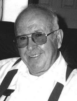
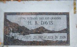
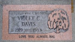
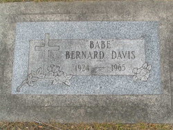
Harold Byron “H B” Davis
| Birth | : | 10 Sep 1917 Voltaire, McHenry County, North Dakota, USA |
| Death | : | 29 Jul 2009 Roseburg, Douglas County, Oregon, USA |
| Burial | : | Zion Episcopal Churchyard, Charles Town, Jefferson County, USA |
| Coordinate | : | 39.2890400, -77.8566600 |
| Description | : | Harold B. "H.B." Davis passed away peacefully on July 29, 2009, in Roseburg, OR, at the age of 91. He had his family at his side when he passed. H.B. was born in North Dakota and spent his youth there. In his youth, he enjoyed fishing with his brothers, playing American Legion baseball and being a caddy at the local golf courses. In his late teens, Harold joined the Civilian Conservation Corps and faithfully sent his pay home to his mother, to help support his family. In the late '30's, H.B., along with his sister, Izzie, and brother-in-law, moved to... Read More |
frequently asked questions (FAQ):
-
Where is Harold Byron “H B” Davis's memorial?
Harold Byron “H B” Davis's memorial is located at: Zion Episcopal Churchyard, Charles Town, Jefferson County, USA.
-
When did Harold Byron “H B” Davis death?
Harold Byron “H B” Davis death on 29 Jul 2009 in Roseburg, Douglas County, Oregon, USA
-
Where are the coordinates of the Harold Byron “H B” Davis's memorial?
Latitude: 39.2890400
Longitude: -77.8566600
Family Members:
Parent
Spouse
Siblings

Children
Flowers:


Nearby Cemetories:
1. Zion Episcopal Churchyard
Charles Town, Jefferson County, USA
Coordinate: 39.2890400, -77.8566600
2. Edge Hill Cemetery
Charles Town, Jefferson County, USA
Coordinate: 39.2882800, -77.8510500
3. Asbury United Methodist Church Cemetery
Charles Town, Jefferson County, USA
Coordinate: 39.2905350, -77.8620834
4. Robert Rutherford Gravesite
Charles Town, Jefferson County, USA
Coordinate: 39.2938499, -77.8452835
5. Fairview Cemetery
Gibsontown, Jefferson County, USA
Coordinate: 39.2695650, -77.8756210
6. Peter K. Johnson Farm Graveyard
Charles Town, Jefferson County, USA
Coordinate: 39.2617536, -77.9051369
7. Washington Burial Ground
Charles Town, Jefferson County, USA
Coordinate: 39.3020379, -77.9163828
8. Quaker Cemetery
Charles Town, Jefferson County, USA
Coordinate: 39.2442586, -77.9017906
9. Johnsontown Cemetery
Johnsontown, Jefferson County, USA
Coordinate: 39.3404200, -77.8910700
10. Poor Farm Cemetery
Kearneysville, Jefferson County, USA
Coordinate: 39.3345590, -77.9094350
11. Saint Andrews on the Mount Episcopal Churchyard
Mountain Mission, Jefferson County, USA
Coordinate: 39.2459970, -77.7967710
12. Murrill Hill United Methodist Church Cemetery
Mountain Mission, Jefferson County, USA
Coordinate: 39.2472900, -77.7950300
13. Payne's Hill Cemetery
Halltown, Jefferson County, USA
Coordinate: 39.3190730, -77.7810570
14. Lock Family Cemetery
Wheatland, Jefferson County, USA
Coordinate: 39.2273780, -77.8872300
15. Kabletown Churchyard
Kabletown, Jefferson County, USA
Coordinate: 39.2215881, -77.8597183
16. Darke-Engle-Ronemous Cemetery
Shenandoah Junction, Jefferson County, USA
Coordinate: 39.3544250, -77.8314400
17. Allstadt Graveyard
Halltown, Jefferson County, USA
Coordinate: 39.3145270, -77.7732030
18. Moler Graveyard
Halltown, Jefferson County, USA
Coordinate: 39.3188400, -77.7739900
19. Chestnut Hill United Methodist Church Cemetery
Harpers Ferry, Jefferson County, USA
Coordinate: 39.2714800, -77.7681500
20. New Hopewell Cemetery
Kearneysville, Jefferson County, USA
Coordinate: 39.3520000, -77.8990000
21. Willow View Blackford Slave Cemetery
Kearneysville, Jefferson County, USA
Coordinate: 39.3607854, -77.8725668
22. Grove Cemetery
Keyes Ferry Acres, Jefferson County, USA
Coordinate: 39.2741014, -77.7644080
23. Mount Zion AME Church Cemetery
Reedson, Jefferson County, USA
Coordinate: 39.3492120, -77.8001050
24. Mount Zion A.M.E. Church Cemetery
Mount Pleasant, Jefferson County, USA
Coordinate: 39.2575322, -77.9485543