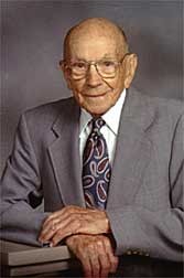
Harold Chapin Hand
| Birth | : | 19 Feb 1911 Seward, Seward County, Nebraska, USA |
| Death | : | 18 Sep 2007 Seward, Seward County, Nebraska, USA |
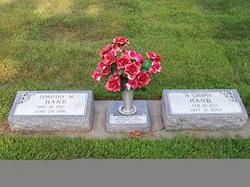
| Burial | : | Eglington Cemetery, Clarksboro, Gloucester County, USA |
| Coordinate | : | 39.7980690, -75.2257462 |
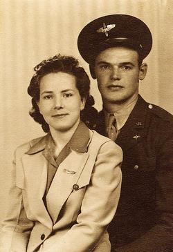
| Description | : | Son of Arch Delmar & Una May (Chapin) Hand. Married to Dorothy Ritchie on 4-8-1934 at the Methodist Parsonage at Papillion, NE. He will be remembered for his family fireworks Stand (1949 to 1982) and The Seward Chinchilla Ranch. He raised chinchillas from 1949 until 1988 winning many awards. His brand 4C (for his 4 children and 4 original chinchillas) was retired in 1997. Chapin was involved in the chinchilla organizations on a local, state and national level. He served four years (1961-1964) on the board of the National Chinchilla Breeders of America. He was on the national board when NCBA consolidated... Read More |
frequently asked questions (FAQ):
-
Where is Harold Chapin Hand's memorial?
Harold Chapin Hand's memorial is located at: Eglington Cemetery, Clarksboro, Gloucester County, USA.
-
When did Harold Chapin Hand death?
Harold Chapin Hand death on 18 Sep 2007 in Seward, Seward County, Nebraska, USA
-
Where are the coordinates of the Harold Chapin Hand's memorial?
Latitude: 39.7980690
Longitude: -75.2257462
Family Members:
Parent
Spouse
Siblings
Flowers:
Nearby Cemetories:
1. Eglington Cemetery
Clarksboro, Gloucester County, USA
Coordinate: 39.7980690, -75.2257462
2. Zion United Methodist Church Cemetery
Clarksboro, Gloucester County, USA
Coordinate: 39.8030891, -75.2191696
3. Alms House Cemetery
Gloucester County, USA
Coordinate: 39.8029980, -75.2142200
4. Lippincott Cemetery
Clarksboro, Gloucester County, USA
Coordinate: 39.8032460, -75.2138660
5. Mickleton Meeting House Graveyard
Mickleton, Gloucester County, USA
Coordinate: 39.7910800, -75.2378900
6. Saint Peters Cemetery
Mount Royal, Gloucester County, USA
Coordinate: 39.8090130, -75.2130090
7. Gates of Heaven Cemetery
Mount Royal, Gloucester County, USA
Coordinate: 39.7961006, -75.1967010
8. Mount Vernon Cemetery
Gibbstown, Gloucester County, USA
Coordinate: 39.8209100, -75.2414600
9. Solomons Graveyard
Wolfert, Gloucester County, USA
Coordinate: 39.7846985, -75.2636032
10. Saint Pauls Methodist Cemetery
Paulsboro, Gloucester County, USA
Coordinate: 39.8295700, -75.2396900
11. Old Stephens Cemetery
West Deptford, Gloucester County, USA
Coordinate: 39.8323970, -75.2179240
12. Mantua Union Graveyard
Mantua, Gloucester County, USA
Coordinate: 39.7902460, -75.1707610
13. Mantua Methodist Cemetery
Mantua, Gloucester County, USA
Coordinate: 39.7883160, -75.1663420
14. Saint Pauls United Methodist Church Cemetery
West Deptford, Gloucester County, USA
Coordinate: 39.8411480, -75.1973650
15. Woodbury Memorial Park
West Deptford, Gloucester County, USA
Coordinate: 39.8266983, -75.1742020
16. Wenonah Cemetery
Wenonah, Gloucester County, USA
Coordinate: 39.7893982, -75.1622009
17. Holy Name of Jesus Catholic Church Cemetery
Mullica Hill, Gloucester County, USA
Coordinate: 39.7411842, -75.2212982
18. Holy Trinity Memorial Garden
Wenonah, Gloucester County, USA
Coordinate: 39.7922200, -75.1514700
19. Saint Stephen's Episcopal Church Cemetery
Mullica Hill, Gloucester County, USA
Coordinate: 39.7388300, -75.2244400
20. Clonmell Methodist Episcopal Church Cemetery
Gibbstown, Gloucester County, USA
Coordinate: 39.8330000, -75.2940000
21. Jesse Chew Cemetery
Gloucester County, USA
Coordinate: 39.7736800, -75.1498250
22. Mullica Hill Baptist Cemetery
Mullica Hill, Gloucester County, USA
Coordinate: 39.7337837, -75.2258377
23. Driver Cemetery
Barnsboro, Gloucester County, USA
Coordinate: 39.7631000, -75.1554900
24. Odd Fellows Cemetery
Jericho, Gloucester County, USA
Coordinate: 39.8077300, -75.1426600

