
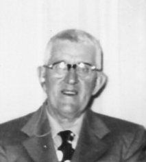
Harold Henry “Blackie” Phelps
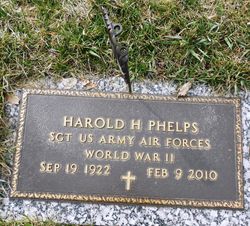
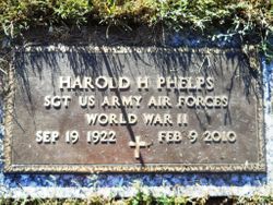
| Birth | : | 19 Sep 1922 Royal, Clay County, Iowa, USA |
| Death | : | 9 Feb 2010 |
| Burial | : | North Lawn Cemetery, Spencer, Clay County, USA |
| Coordinate | : | 43.1600000, -95.1470000 |
| Description | : | Harold Henry Phelps September 19, 1922 - February 9, 2010 Harold Henry 'Blackie' Phelps, the son of Ernest and Goldie (Stanton) Phelps, was born September 19, 1922 in Royal, Iowa. His childhood years were spent in Royal, where he received his education. Following his schooling, he entered the military, where he served with the U.S. Air Corps during WWII from 1942 until his honorable discharge in 1945. Harold married Eleanor Huss on November 29, 1952 at St. Louis Catholic Church in Royal, Iowa. Following their marriage, they continued to live in Royal, where he worked as a carpenter, was... Read More |
frequently asked questions (FAQ):
-
Where is Harold Henry “Blackie” Phelps's memorial?
Harold Henry “Blackie” Phelps's memorial is located at: North Lawn Cemetery, Spencer, Clay County, USA.
-
When did Harold Henry “Blackie” Phelps death?
Harold Henry “Blackie” Phelps death on 9 Feb 2010 in
-
Where are the coordinates of the Harold Henry “Blackie” Phelps's memorial?
Latitude: 43.1600000
Longitude: -95.1470000
Family Members:
Parent
Spouse
Siblings

Children
Flowers:


Nearby Cemetories:
1. North Lawn Cemetery
Spencer, Clay County, USA
Coordinate: 43.1600000, -95.1470000
2. Dewey Readmore Books Memorial
Spencer, Clay County, USA
Coordinate: 43.1403999, -95.1443024
3. Riverside Cemetery
Spencer, Clay County, USA
Coordinate: 43.1441994, -95.1671982
4. Fairview Cemetery
Clay County, USA
Coordinate: 43.1899986, -95.0800018
5. Evergreen Cemetery
Clay County, USA
Coordinate: 43.2052994, -95.2086029
6. Dickens Cemetery
Dickens, Clay County, USA
Coordinate: 43.1280000, -95.0155000
7. Swedish Lutheran Cemetery
Royal, Clay County, USA
Coordinate: 43.0683000, -95.2350000
8. Little Sioux Lutheran Cemetery
Milford, Dickinson County, USA
Coordinate: 43.2702065, -95.2109528
9. Rosehill Cemetery
Clay County, USA
Coordinate: 43.0368996, -95.0919037
10. First Reformed Cemetery
Clay County, USA
Coordinate: 43.2399500, -95.2889000
11. Lone Tree Cemetery
Everly, Clay County, USA
Coordinate: 43.1411018, -95.3347015
12. Milford Cemetery
Milford, Dickinson County, USA
Coordinate: 43.3092003, -95.1481018
13. Lincoln Cemetery
Rossie, Clay County, USA
Coordinate: 43.0111008, -95.2313995
14. Calvary Cemetery
Milford, Dickinson County, USA
Coordinate: 43.3213997, -95.1688995
15. Logan Township Cemetery
Clay County, USA
Coordinate: 43.0489006, -94.9747009
16. Liberty Cemetery
Greenville, Clay County, USA
Coordinate: 42.9897003, -95.1417007
17. Willow Creek Cemetery
Royal, Clay County, USA
Coordinate: 43.0214005, -95.2885971
18. Clay Center Cemetery
Royal, Clay County, USA
Coordinate: 43.0410995, -95.3272018
19. TriMello Cemetery
Royal, Clay County, USA
Coordinate: 43.0682983, -95.3728027
20. Crown Hill Cemetery
Ruthven, Palo Alto County, USA
Coordinate: 43.1328011, -94.8878021
21. Calvary Cemetery
Ruthven, Palo Alto County, USA
Coordinate: 43.1314011, -94.8869019
22. Zion Methodist Cemetery
Clay County, USA
Coordinate: 42.9808006, -95.2497025
23. Westport Cemetery
Dickinson County, USA
Coordinate: 43.3130989, -95.3289032
24. Okoboji Cemetery
Arnolds Park, Dickinson County, USA
Coordinate: 43.3649406, -95.1303558