

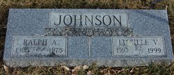
Lucille Vina Phelps Johnson
| Birth | : | 17 Mar 1910 Sioux Falls, Minnehaha County, South Dakota, USA |
| Death | : | 6 Jul 1999 Spencer, Clay County, Iowa, USA |
| Burial | : | Riverside Cemetery, Spencer, Clay County, USA |
| Coordinate | : | 43.1441994, -95.1671982 |
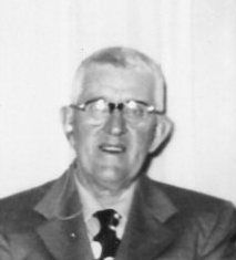
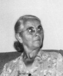
| Description | : | Lucille Vina Johnson, the daughter of Ernest Ray and Golden Stanton Phelps, was born March 17, 1910, in Sioux Falls, South Dakota. Her early childhood years were spent in Royal, Iowa, where she attended grade school. Her family later moved to Mt. Vernon, South Dakota, where she attended high school. Lucille married Ralph A. Johnson on October 17, 1945, in Minneapolis, Minnesota. During the early years of their marriage they made their home in Storm Lake, Iowa, before moving to Des Moines in 1960. Following Ralph's death in 1975, Lucille moved to Spencer, where she has made her home since... Read More |
frequently asked questions (FAQ):
-
Where is Lucille Vina Phelps Johnson's memorial?
Lucille Vina Phelps Johnson's memorial is located at: Riverside Cemetery, Spencer, Clay County, USA.
-
When did Lucille Vina Phelps Johnson death?
Lucille Vina Phelps Johnson death on 6 Jul 1999 in Spencer, Clay County, Iowa, USA
-
Where are the coordinates of the Lucille Vina Phelps Johnson's memorial?
Latitude: 43.1441994
Longitude: -95.1671982
Family Members:
Parent
Spouse
Siblings

Children
Flowers:


Nearby Cemetories:
1. Riverside Cemetery
Spencer, Clay County, USA
Coordinate: 43.1441994, -95.1671982
2. Dewey Readmore Books Memorial
Spencer, Clay County, USA
Coordinate: 43.1403999, -95.1443024
3. North Lawn Cemetery
Spencer, Clay County, USA
Coordinate: 43.1600000, -95.1470000
4. Evergreen Cemetery
Clay County, USA
Coordinate: 43.2052994, -95.2086029
5. Fairview Cemetery
Clay County, USA
Coordinate: 43.1899986, -95.0800018
6. Swedish Lutheran Cemetery
Royal, Clay County, USA
Coordinate: 43.0683000, -95.2350000
7. Dickens Cemetery
Dickens, Clay County, USA
Coordinate: 43.1280000, -95.0155000
8. Rosehill Cemetery
Clay County, USA
Coordinate: 43.0368996, -95.0919037
9. Lone Tree Cemetery
Everly, Clay County, USA
Coordinate: 43.1411018, -95.3347015
10. Little Sioux Lutheran Cemetery
Milford, Dickinson County, USA
Coordinate: 43.2702065, -95.2109528
11. First Reformed Cemetery
Clay County, USA
Coordinate: 43.2399500, -95.2889000
12. Lincoln Cemetery
Rossie, Clay County, USA
Coordinate: 43.0111008, -95.2313995
13. Willow Creek Cemetery
Royal, Clay County, USA
Coordinate: 43.0214005, -95.2885971
14. Liberty Cemetery
Greenville, Clay County, USA
Coordinate: 42.9897003, -95.1417007
15. Clay Center Cemetery
Royal, Clay County, USA
Coordinate: 43.0410995, -95.3272018
16. Milford Cemetery
Milford, Dickinson County, USA
Coordinate: 43.3092003, -95.1481018
17. TriMello Cemetery
Royal, Clay County, USA
Coordinate: 43.0682983, -95.3728027
18. Logan Township Cemetery
Clay County, USA
Coordinate: 43.0489006, -94.9747009
19. Zion Methodist Cemetery
Clay County, USA
Coordinate: 42.9808006, -95.2497025
20. Calvary Cemetery
Milford, Dickinson County, USA
Coordinate: 43.3213997, -95.1688995
21. Fanny Fern Cemetery
Clay County, USA
Coordinate: 42.9530983, -95.1607971
22. Crown Hill Cemetery
Ruthven, Palo Alto County, USA
Coordinate: 43.1328011, -94.8878021
23. Calvary Cemetery
Ruthven, Palo Alto County, USA
Coordinate: 43.1314011, -94.8869019
24. Westport Cemetery
Dickinson County, USA
Coordinate: 43.3130989, -95.3289032