
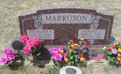
Harold J Markuson
| Birth | : | 10 May 1918 Toole County, Montana, USA |
| Death | : | 18 Dec 1981 Toole County, Montana, USA |
| Burial | : | Trinity Church Cemetery, Lothair, Liberty County, USA |
| Coordinate | : | 48.7263000, -111.2296000 |
| Description | : | Asphyxiation Claims Galata Pair Harold J. Markuson, 63, and his wife Theodora A., 59, were found dead in their home 15 miles northeast of Galata Friday forenoon. Death was attributed to asphyxiation. Investigation is continuing. No foul play is suspected. According to reports they had gone home Thursday night, and their bodies were discovered by their son, Duane, at 10:30 Friday forenoon. They were both in bed. The coroner took the bodies to Great Falls for an autopsy where they found a high concentration of carbon monoxide. Services were held Monday at 1 p.m. at Trinity Lutheran Church 18 miles north of... Read More |
frequently asked questions (FAQ):
-
Where is Harold J Markuson's memorial?
Harold J Markuson's memorial is located at: Trinity Church Cemetery, Lothair, Liberty County, USA.
-
When did Harold J Markuson death?
Harold J Markuson death on 18 Dec 1981 in Toole County, Montana, USA
-
Where are the coordinates of the Harold J Markuson's memorial?
Latitude: 48.7263000
Longitude: -111.2296000
Family Members:
Parent
Spouse

Siblings
Flowers:


Nearby Cemetories:
1. Trinity Church Cemetery
Lothair, Liberty County, USA
Coordinate: 48.7263000, -111.2296000
2. Eagle Creek Colony Cemetery
Chester, Liberty County, USA
Coordinate: 48.6976000, -111.2011000
3. Grandview Cemetery
Toole County, USA
Coordinate: 48.7265000, -111.3615000
4. Old Indian Cemetery
Liberty County, USA
Coordinate: 48.8680992, -111.2585983
5. Whitlash Cemetery
Liberty County, USA
Coordinate: 48.9085999, -111.2699966
6. Gold Butte Cemetery
Toole County, USA
Coordinate: 48.8793983, -111.3966980
7. Lothair Protestant Cemetery
Lothair, Liberty County, USA
Coordinate: 48.4694000, -111.2393100
8. Lothair Catholic Cemetery
Lothair, Liberty County, USA
Coordinate: 48.4687000, -111.2484000
9. Sage Creek Colony Cemetery
Sage Creek Colony, Liberty County, USA
Coordinate: 48.9271000, -110.9735000
10. Chester Cemetery
Chester, Liberty County, USA
Coordinate: 48.5219002, -110.9807968
11. Galata Cemetery
Toole County, USA
Coordinate: 48.4655991, -111.3349991
12. Devon Cemetery
Toole County, USA
Coordinate: 48.4693000, -111.4713000
13. Sunnyside Cemetery
Aden, Medicine Hat Census Division, Canada
Coordinate: 49.0286300, -111.3240800
14. Joplin Cemetery
Joplin, Liberty County, USA
Coordinate: 48.5576720, -110.7622930
15. Nutter Ranch Cemetery
Sunburst, Toole County, USA
Coordinate: 48.9668200, -111.6365320
16. Dunkirk Cemetery
Dunkirk, Toole County, USA
Coordinate: 48.4797810, -111.6761860
17. Bethel Cemetery
Hill County, USA
Coordinate: 48.6685982, -110.6406021
18. Inverness Cemetery
Hill County, USA
Coordinate: 48.5531340, -110.6688450
19. Grace Church Cemetery
Rudyard, Hill County, USA
Coordinate: 48.8269930, -110.6209890
20. Cool Spring Colony Cemetery
Rudyard, Hill County, USA
Coordinate: 48.7704000, -110.5860000
21. Erickson Cemetery
Liberty County, USA
Coordinate: 48.3143997, -110.9503021
22. Sunburst Cemetery
Sunburst, Toole County, USA
Coordinate: 48.8847800, -111.8743800
23. Omholt Cemetery
Toole County, USA
Coordinate: 48.3058014, -111.5346985
24. Mountain View Cemetery
Shelby, Toole County, USA
Coordinate: 48.5032200, -111.8675800