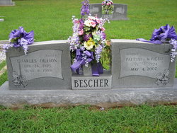
| Birth | : | 31 Jul 1925 Randolph County, North Carolina, USA |
| Death | : | 10 Mar 2003 Asheboro, Randolph County, North Carolina, USA |
| Burial | : | Pleasant Ridge Christian Church Cemetery, Ramseur, Randolph County, USA |
| Coordinate | : | 35.7046860, -79.6670060 |
| Description | : | FRANKLINVILLE - Harold Lloyd Wright, 77, of 7 Pleasant Ridge Road, died Monday, March 10, 2003, at Randolph Hospital. Funeral service will be 11 a.m. Thursday at Pleasant Ridge Christian Church with Randy Robbins, the Rev. Danny Miller and the Rev. Steve Johnson officiating. Burial will follow in the church cemetery. He was a Randolph County native, a retired farmer and sawmiller, and a U.S. Army veteran of World War II. Surviving are son, Phillip Wright of Liberty; daughters, Lola Keene-Swaim, Merita Wall and Nancy Lucas, all of Franklinville; brother, David Wright of Asheboro, sisters, Pauline Bescher of Denton, Alease... Read More |
frequently asked questions (FAQ):
-
Where is Harold Lloyd Wright's memorial?
Harold Lloyd Wright's memorial is located at: Pleasant Ridge Christian Church Cemetery, Ramseur, Randolph County, USA.
-
When did Harold Lloyd Wright death?
Harold Lloyd Wright death on 10 Mar 2003 in Asheboro, Randolph County, North Carolina, USA
-
Where are the coordinates of the Harold Lloyd Wright's memorial?
Latitude: 35.7046860
Longitude: -79.6670060
Family Members:
Parent
Spouse
Siblings
Flowers:
Nearby Cemetories:
1. Pleasant Ridge Christian Church Cemetery
Ramseur, Randolph County, USA
Coordinate: 35.7046860, -79.6670060
2. Mill Creek Friends Cemetery
Asheboro, Randolph County, USA
Coordinate: 35.6922270, -79.6463380
3. Ramseur Wesleyan Church Cemetery
Ramseur, Randolph County, USA
Coordinate: 35.7305670, -79.6593030
4. Harmony Baptist Church Cemetery
Ramseur, Randolph County, USA
Coordinate: 35.7241680, -79.6418910
5. Parks-Stout Cemetery
Randolph County, USA
Coordinate: 35.7205460, -79.6373740
6. Sunset Knoll Cemetery
Ramseur, Randolph County, USA
Coordinate: 35.7313995, -79.6500015
7. Holly Spring Friends Meeting Cemetery
Ramseur, Randolph County, USA
Coordinate: 35.6697270, -79.6676470
8. Old Salem Cemetery
Franklinville, Randolph County, USA
Coordinate: 35.7414017, -79.6742020
9. Stouts Chapel UMC Cemetery
Ramseur, Randolph County, USA
Coordinate: 35.6647210, -79.6646660
10. Friendship AME Church Cemetery
Ramseur, Randolph County, USA
Coordinate: 35.7463280, -79.6437970
11. Mountain of Faith Christian Church Cemetery
Asheboro, Randolph County, USA
Coordinate: 35.6760930, -79.7129830
12. First Baptist Church Cemetery
Franklinville, Randolph County, USA
Coordinate: 35.7482230, -79.6908630
13. Providence Baptist Church Cemetery
Asheboro, Randolph County, USA
Coordinate: 35.7231400, -79.7237930
14. Parks Crossroads Christian Church Cemetery
Ramseur, Randolph County, USA
Coordinate: 35.7048240, -79.6045480
15. Coxs Chapel United Methodist Church Cemetery
Ramseur, Randolph County, USA
Coordinate: 35.6919860, -79.6064320
16. Franklinville United Methodist Church Cemetery
Franklinville, Randolph County, USA
Coordinate: 35.7462900, -79.7037500
17. Shady Grove Community Cemetery
Asheboro, Randolph County, USA
Coordinate: 35.7192180, -79.7287920
18. Pleasant Cross Christian Church Cemetery
Asheboro, Randolph County, USA
Coordinate: 35.7254000, -79.7268740
19. Mount Tabor Community Church Cemetery
Asheboro, Randolph County, USA
Coordinate: 35.6892900, -79.7318400
20. Billy Trogdon Cemetery
Asheboro, Randolph County, USA
Coordinate: 35.7392800, -79.7219100
21. Bible Truth Church Cemetery
Ramseur, Randolph County, USA
Coordinate: 35.7485370, -79.6204580
22. Spoons Chapel United Church of Christ Cemetery
Asheboro, Randolph County, USA
Coordinate: 35.6763150, -79.7345110
23. Clear View Baptist Church Cemetery
Franklinville, Randolph County, USA
Coordinate: 35.7530800, -79.7234300
24. Cedar Falls United Methodist Church Cemetery
Asheboro, Randolph County, USA
Coordinate: 35.7472920, -79.7338990


