
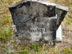
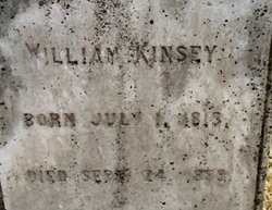
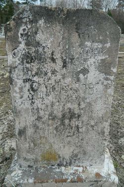
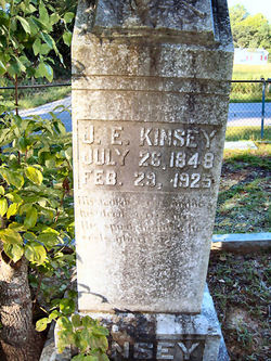
Harriet Ann Smoak Kinsey
| Birth | : | 24 Jul 1818 Colleton County, South Carolina, USA |
| Death | : | 28 Feb 1895 Colleton County, South Carolina, USA |
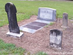
| Burial | : | Saint Marys Cemetery, Bethel, Fairfield County, USA |
| Coordinate | : | 41.3591995, -73.4167023 |
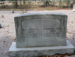
| Description | : | Harriet Ann Smoak was the daughter of David William Smoak and Susan Charity "Lottie" (Prine) Smoak. Harriet Ann Smoak married William Kinsey. |
frequently asked questions (FAQ):
-
Where is Harriet Ann Smoak Kinsey's memorial?
Harriet Ann Smoak Kinsey's memorial is located at: Saint Marys Cemetery, Bethel, Fairfield County, USA.
-
When did Harriet Ann Smoak Kinsey death?
Harriet Ann Smoak Kinsey death on 28 Feb 1895 in Colleton County, South Carolina, USA
-
Where are the coordinates of the Harriet Ann Smoak Kinsey's memorial?
Latitude: 41.3591995
Longitude: -73.4167023
Family Members:
Parent

Spouse
Siblings
Children
Flowers:


Nearby Cemetories:
1. 66 Nashville Road Cemetery
Bethel, Fairfield County, USA
Coordinate: 41.3653710, -73.4090270
2. Center Cemetery
Bethel, Fairfield County, USA
Coordinate: 41.3698692, -73.4129486
3. Congregational Church Cemetery
Bethel, Fairfield County, USA
Coordinate: 41.3729591, -73.4085693
4. Wolfpit Cemetery
Bethel, Fairfield County, USA
Coordinate: 41.3591000, -73.3789000
5. Long Ridge Cemetery
Danbury, Fairfield County, USA
Coordinate: 41.3371000, -73.4438000
6. Putnam Memorial State Park
Redding, Fairfield County, USA
Coordinate: 41.3421478, -73.3833084
7. Bethel Cemetery Elmwood Section
Bethel, Fairfield County, USA
Coordinate: 41.3769000, -73.3817000
8. Saint James Church Cemetery
Danbury, Fairfield County, USA
Coordinate: 41.3863830, -73.4437250
9. Isaac Hamilton Cemetery
Redding, Fairfield County, USA
Coordinate: 41.3297424, -73.3904114
10. Old Saint Peters Cemetery
Danbury, Fairfield County, USA
Coordinate: 41.3909760, -73.4381104
11. Wooster Street Cemetery
Danbury, Fairfield County, USA
Coordinate: 41.3899540, -73.4495420
12. Upper Starrs Plain Cemetery
Danbury, Fairfield County, USA
Coordinate: 41.3392000, -73.4654000
13. Saint James Episcopal Church Memorial Garden
Danbury, Fairfield County, USA
Coordinate: 41.3932750, -73.4528310
14. United Jewish Cemetery
Danbury, Fairfield County, USA
Coordinate: 41.3694100, -73.4769000
15. Children of Israel Cemetery
Danbury, Fairfield County, USA
Coordinate: 41.3690681, -73.4772110
16. Miry Brook Cemetery
Danbury, Fairfield County, USA
Coordinate: 41.3686790, -73.4773636
17. Lower Starrs Plain Cemetery
Danbury, Fairfield County, USA
Coordinate: 41.3287392, -73.4654922
18. Stony Hill Cemetery
Bethel, Fairfield County, USA
Coordinate: 41.4055252, -73.3881607
19. Wooster Cemetery
Danbury, Fairfield County, USA
Coordinate: 41.4035988, -73.4503021
20. Flat Swamp Cemetery #01
Newtown, Fairfield County, USA
Coordinate: 41.3745689, -73.3469772
21. Flat Swamp Cemetery #2
Newtown, Fairfield County, USA
Coordinate: 41.3752556, -73.3464661
22. Old North Main Street Cemetery
Danbury, Fairfield County, USA
Coordinate: 41.4044000, -73.4600000
23. Saint Platons Russian Orthodox Cemetery
Danbury, Fairfield County, USA
Coordinate: 41.4129500, -73.4382900
24. Immanuel Lutheran Cemetery
Danbury, Fairfield County, USA
Coordinate: 41.4110489, -73.4499207