Harriet E. Johns West
| Birth | : | Oct 1858 Florida, USA |
| Death | : | 2 Jul 1922 Orange Park, Clay County, Florida, USA |
| Burial | : | Whiskeytown Cemetery, Whiskeytown, Shasta County, USA |
| Coordinate | : | 40.5858002, -122.5381012 |
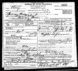
| Description | : | Florida Times Union Obit 3 July 1922- Mrs Harriet West, aged 64, a highly esteemed resident of Clay County, where she had resided all of her life, died Sunday at 2 pm at her residence at Orange Park after a prolonged illness. Her lovable Christian character had endeared her to many friends, who will be deeply grieved to learn of her death. Funeral services were held Sunday. Interment was in the family plot in Landers (sic) Cemetery. (misprint, should be Souter) Daughter of Andrew and Martha Johns. Wife of Joshua Nelson West. Mother of ten children. |
frequently asked questions (FAQ):
-
Where is Harriet E. Johns West's memorial?
Harriet E. Johns West's memorial is located at: Whiskeytown Cemetery, Whiskeytown, Shasta County, USA.
-
When did Harriet E. Johns West death?
Harriet E. Johns West death on 2 Jul 1922 in Orange Park, Clay County, Florida, USA
-
Where are the coordinates of the Harriet E. Johns West's memorial?
Latitude: 40.5858002
Longitude: -122.5381012
Family Members:
Parent
Spouse
Siblings
Children
Flowers:
Nearby Cemetories:
1. Whiskeytown Cemetery
Whiskeytown, Shasta County, USA
Coordinate: 40.5858002, -122.5381012
2. Charles Brownstein Gravesite
Shasta, Shasta County, USA
Coordinate: 40.6038810, -122.4992540
3. Shasta Catholic Cemetery
Shasta, Shasta County, USA
Coordinate: 40.6014950, -122.4917190
4. Shasta Union Cemetery
Shasta, Shasta County, USA
Coordinate: 40.6008682, -122.4906845
5. Shasta Masonic Cemetery
Shasta, Shasta County, USA
Coordinate: 40.5910492, -122.4859695
6. Middletown Cemetery
Redding, Shasta County, USA
Coordinate: 40.5392800, -122.4748700
7. Igo Cemetery
Igo, Shasta County, USA
Coordinate: 40.5130501, -122.5375977
8. Saint Joseph Cemetery
Redding, Shasta County, USA
Coordinate: 40.5824509, -122.4310989
9. Barbara Glass Gravesite
Shasta County, USA
Coordinate: 40.5067600, -122.5049700
10. Texas Springs Cemetery
Redding, Shasta County, USA
Coordinate: 40.5116844, -122.4516144
11. All Saints Episcopal Church Columbarium
Redding, Shasta County, USA
Coordinate: 40.5974900, -122.4010600
12. Northern California Veterans Cemetery
Igo, Shasta County, USA
Coordinate: 40.4785400, -122.5422500
13. Levi Tower Gravesite
French Gulch, Shasta County, USA
Coordinate: 40.6644860, -122.6365180
14. Old Saint Joseph Cemetery
Redding, Shasta County, USA
Coordinate: 40.5781326, -122.3912811
15. Redding Memorial Park
Redding, Shasta County, USA
Coordinate: 40.5894814, -122.3872833
16. Shasta General Hospital Cemetery
Redding, Shasta County, USA
Coordinate: 40.5516000, -122.3894000
17. Buckeye Pioneer Cemetery
Buckeye, Shasta County, USA
Coordinate: 40.6432991, -122.4006195
18. Shasta General Hospital Cemetery
Redding, Shasta County, USA
Coordinate: 40.5509200, -122.3841800
19. Philpott Cemetery
Ono, Shasta County, USA
Coordinate: 40.4770012, -122.6194992
20. Ono Cemetery
Ono, Shasta County, USA
Coordinate: 40.4692497, -122.6131821
21. Fann-Slaughter Cemetery
Shasta County, USA
Coordinate: 40.4720500, -122.6280400
22. Happy Valley Cemetery
Redding, Shasta County, USA
Coordinate: 40.4668999, -122.4535980
23. French Gulch Catholic Cemetery
French Gulch, Shasta County, USA
Coordinate: 40.6968994, -122.6402512
24. Newtown Cemetery
Shasta Lake, Shasta County, USA
Coordinate: 40.6627655, -122.3911972


