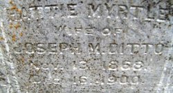
Harriet Myrtle “Hattie” Partell Ditto
| Birth | : | 13 Nov 1868 Iowa, USA |
| Death | : | 16 Dec 1900 Nebraska City, Otoe County, Nebraska, USA |
| Burial | : | Pleasant Hill Cemetery, Aurelia, Cherokee County, USA |
| Coordinate | : | 42.7024994, -95.4460983 |
| Inscription | : | Wife of Joseph M. Ditto |
| Description | : | Mrs. Hattie M., wife of J. M. Ditto, died quite suddenly last night at her home, aged 32 years. She had been sick for about two weeks but lately was improving. Yesterday she was able to sit up all day and apparently was in good health, but about 9 o'clock she complained of severe pains in her head and soon passed to unconsciousness. Dr. Bedell was called but she was past the aid of medicine and about midnight passed to the great beyond. She leaves a husband and one son. The funeral services were held... Read More |
frequently asked questions (FAQ):
-
Where is Harriet Myrtle “Hattie” Partell Ditto's memorial?
Harriet Myrtle “Hattie” Partell Ditto's memorial is located at: Pleasant Hill Cemetery, Aurelia, Cherokee County, USA.
-
When did Harriet Myrtle “Hattie” Partell Ditto death?
Harriet Myrtle “Hattie” Partell Ditto death on 16 Dec 1900 in Nebraska City, Otoe County, Nebraska, USA
-
Where are the coordinates of the Harriet Myrtle “Hattie” Partell Ditto's memorial?
Latitude: 42.7024994
Longitude: -95.4460983
Family Members:
Spouse
Children
Flowers:
Nearby Cemetories:
1. Pleasant Hill Cemetery
Aurelia, Cherokee County, USA
Coordinate: 42.7024994, -95.4460983
2. Good Hope Cemetery
Cherokee, Cherokee County, USA
Coordinate: 42.6618996, -95.5258026
3. Diamond Cemetery
Cherokee County, USA
Coordinate: 42.6156006, -95.4480972
4. Haight Family Farm Cemetery
Aurelia, Cherokee County, USA
Coordinate: 42.7778400, -95.3781060
5. Scandinavian Cemetery
Alta, Buena Vista County, USA
Coordinate: 42.6833000, -95.3107986
6. George Donohoe Grave Site
Cherokee, Cherokee County, USA
Coordinate: 42.7571850, -95.5704080
7. West Pilot Cemetery
Cherokee County, USA
Coordinate: 42.6674995, -95.5841980
8. Beacon Hollow Cemetery
Cherokee, Cherokee County, USA
Coordinate: 42.7572057, -95.5727856
9. Afton Cemetery
Cherokee County, USA
Coordinate: 42.8064003, -95.4863968
10. Oak Hill Cemetery
Cherokee, Cherokee County, USA
Coordinate: 42.7496986, -95.5796967
11. Saint John Lutheran Cemetery
Hanover, Buena Vista County, USA
Coordinate: 42.6053467, -95.3725739
12. Memory Gardens
Cherokee, Cherokee County, USA
Coordinate: 42.7778015, -95.5580978
13. Elk Cemetery
Elk Township, Buena Vista County, USA
Coordinate: 42.7641983, -95.3094025
14. Woodlawn Cemetery
Alta, Buena Vista County, USA
Coordinate: 42.6730600, -95.2908300
15. Mount Calvary Cemetery
Cherokee, Cherokee County, USA
Coordinate: 42.7639008, -95.5847015
16. Immanuel Lutheran Church Cemetery
Aurelia, Cherokee County, USA
Coordinate: 42.8165000, -95.3885000
17. Plainview Cemetery
Alta, Buena Vista County, USA
Coordinate: 42.8087100, -95.3280200
18. Silver Cemetery
Quimby, Cherokee County, USA
Coordinate: 42.6058006, -95.5950012
19. Cedar Cemetery
Larrabee, Cherokee County, USA
Coordinate: 42.8361015, -95.5346985
20. Cherokee County Pioneer Cemetery
Spring Township, Cherokee County, USA
Coordinate: 42.8502998, -95.4906006
21. Maple Valley Township Cemetery
Alta, Buena Vista County, USA
Coordinate: 42.5752600, -95.3199980
22. Buena Vista Memorial Park Cemetery
Storm Lake, Buena Vista County, USA
Coordinate: 42.6539001, -95.2339020
23. Grandview Cemetery
Quimby, Cherokee County, USA
Coordinate: 42.6183014, -95.6417007
24. Meriden Cemetery
Meriden, Cherokee County, USA
Coordinate: 42.7868996, -95.6425018


