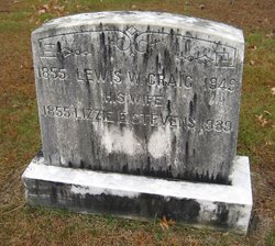
| Birth | : | 1816 Farmington, Franklin County, Maine, USA |
| Death | : | 13 Sep 1910 Boscawen, Merrimack County, New Hampshire, USA |
| Burial | : | Riverside Cemetery, Farmington, Franklin County, USA |
| Coordinate | : | 44.6587900, -70.1432600 |
| Description | : | Harriet was the 2nd wife to Hiram Belcher Craig. She helped raised his little infant daugther, Sophie after her Mother died soon after child birth. She and Hiram never had any children of their own. |
frequently asked questions (FAQ):
-
Where is Harriet Whittier Craig's memorial?
Harriet Whittier Craig's memorial is located at: Riverside Cemetery, Farmington, Franklin County, USA.
-
When did Harriet Whittier Craig death?
Harriet Whittier Craig death on 13 Sep 1910 in Boscawen, Merrimack County, New Hampshire, USA
-
Where are the coordinates of the Harriet Whittier Craig's memorial?
Latitude: 44.6587900
Longitude: -70.1432600
Family Members:
Parent
Spouse
Siblings
Children
Flowers:
Nearby Cemetories:
1. Riverside Cemetery
Farmington, Franklin County, USA
Coordinate: 44.6587900, -70.1432600
2. Fairview Cemetery
Farmington, Franklin County, USA
Coordinate: 44.6581001, -70.1382980
3. Butterfield Cemetery
Farmington, Franklin County, USA
Coordinate: 44.6520700, -70.1511140
4. Old Burying Ground
Farmington, Franklin County, USA
Coordinate: 44.6638660, -70.1567270
5. Center Burying Ground
Farmington, Franklin County, USA
Coordinate: 44.6712700, -70.1514400
6. Case Cemetery
Farmington, Franklin County, USA
Coordinate: 44.6518900, -70.1247900
7. Belcher Family Graveyard
Farmington, Franklin County, USA
Coordinate: 44.6739269, -70.1488538
8. Red Schoolhouse Cemetery
Franklin County, USA
Coordinate: 44.6314011, -70.1600037
9. Gower Cemetery
Franklin County, USA
Coordinate: 44.6380997, -70.1010971
10. Lowell Cemetery
Franklin County, USA
Coordinate: 44.6292000, -70.1102982
11. Russell Mills Cemetery
Farmington, Franklin County, USA
Coordinate: 44.6695862, -70.1945016
12. North Farmington Cemetery
Farmington, Franklin County, USA
Coordinate: 44.6981000, -70.1794000
13. Sewall Cemetery
Farmington, Franklin County, USA
Coordinate: 44.7001260, -70.0976010
14. Blake Cemetery
Farmington Falls, Franklin County, USA
Coordinate: 44.6258011, -70.0817032
15. East Wilton Cemetery
Wilton, Franklin County, USA
Coordinate: 44.6124700, -70.1878800
16. Holly Cemetery
Farmington, Franklin County, USA
Coordinate: 44.7178001, -70.1371994
17. Temple Village Cemetery
Temple, Franklin County, USA
Coordinate: 44.6831017, -70.2210999
18. Wendall Davis Cemetery
Farmington, Franklin County, USA
Coordinate: 44.7149000, -70.1110200
19. Orchard Hill Cemetery
Temple, Franklin County, USA
Coordinate: 44.6713680, -70.2318424
20. Webster Cemetery
Franklin County, USA
Coordinate: 44.5924988, -70.1241989
21. Zions Hill Cemetery
North Chesterville, Franklin County, USA
Coordinate: 44.5918999, -70.1085968
22. Weeks Mills Cemetery
New Sharon, Franklin County, USA
Coordinate: 44.6732600, -70.0429100
23. Chesterville Hill Cemetery
Chesterville, Franklin County, USA
Coordinate: 44.6060982, -70.0721970
24. Allens Mills Cemetery
Industry, Franklin County, USA
Coordinate: 44.7180800, -70.0780100


