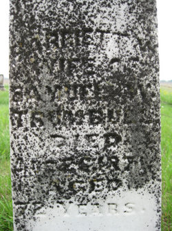
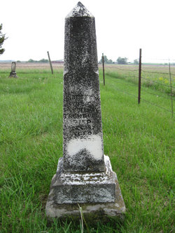
Harriett Townsend Wells Trumbull
| Birth | : | 1798 New York, USA |
| Death | : | 26 Aug 1871 Allen County, Kansas, USA |
| Burial | : | Mound Hill Cemetery, Eaton, Preble County, USA |
| Coordinate | : | 39.7411003, -84.6461029 |
| Description | : | Wife of Samuel Wescott Trumbull. Harriett shares a gravestone with her daughter-in-law, Rebecca M. Trumbull (wife of Samuel and Harriett's son, Henry L. Trumbull). 1905 History of Crawford County, Kansas: (paraphrased from an entry about John Tharp): In this book, there is an excerpt about settler John Tharp, who was married to Samuel and Harriett's oldest child, Martha W. Trumbull in Delaware Co., OH in 1850. This excerpt states that Martha's father (Samuel) was born in Connecticut and her mother (Harriett) in Canada. Her grandfather (Samuel's father) was a Revolutionary War soldier and her father (Samuel) was a soldier... Read More |
frequently asked questions (FAQ):
-
Where is Harriett Townsend Wells Trumbull's memorial?
Harriett Townsend Wells Trumbull's memorial is located at: Mound Hill Cemetery, Eaton, Preble County, USA.
-
When did Harriett Townsend Wells Trumbull death?
Harriett Townsend Wells Trumbull death on 26 Aug 1871 in Allen County, Kansas, USA
-
Where are the coordinates of the Harriett Townsend Wells Trumbull's memorial?
Latitude: 39.7411003
Longitude: -84.6461029
Family Members:
Spouse
Children
Flowers:
Nearby Cemetories:
1. Mound Hill Cemetery
Eaton, Preble County, USA
Coordinate: 39.7411003, -84.6461029
2. Fort Saint Clair Cemetery
Preble County, USA
Coordinate: 39.7374992, -84.6549988
3. Preble County Home Cemetery
Eaton, Preble County, USA
Coordinate: 39.7618970, -84.6481170
4. Fisher Cemetery
Eaton, Preble County, USA
Coordinate: 39.7289400, -84.6185600
5. Campbell Cemetery
Eaton, Preble County, USA
Coordinate: 39.7172740, -84.6224530
6. Antioch Cemetery
Eaton, Preble County, USA
Coordinate: 39.7000008, -84.6318970
7. Crumbaker Cemetery
Eaton, Preble County, USA
Coordinate: 39.7696730, -84.6904060
8. Bell Cemetery
Eaton, Preble County, USA
Coordinate: 39.7582970, -84.5886040
9. Friendship Cemetery
Sugar Valley, Preble County, USA
Coordinate: 39.7043991, -84.6939011
10. Spacht Cemetery
Preble County, USA
Coordinate: 39.7875500, -84.6774500
11. Fisher Cemetery
West Alexandria, Preble County, USA
Coordinate: 39.7267200, -84.5760600
12. Frame Cemetery
Eaton, Preble County, USA
Coordinate: 39.7641560, -84.7122290
13. Preble Memory Gardens
West Alexandria, Preble County, USA
Coordinate: 39.7451782, -84.5727539
14. Sample-Stover Cemetery
Sampleville, Preble County, USA
Coordinate: 39.7417870, -84.5708070
15. Bonebrake Cemetery
New Hope, Preble County, USA
Coordinate: 39.7867200, -84.6999600
16. Zion Cemetery
Eaton, Preble County, USA
Coordinate: 39.8104858, -84.6306305
17. Camp Run Cemetery
Wheatville, Preble County, USA
Coordinate: 39.6758347, -84.6083298
18. Harris Cemetery
West Florence, Preble County, USA
Coordinate: 39.7262500, -84.7370300
19. Marshall Graveyard
Sugar Valley, Preble County, USA
Coordinate: 39.6883580, -84.7092460
20. Poyner Cemetery
Preble County, USA
Coordinate: 39.6739006, -84.6853027
21. Conger Graveyard
Sugar Valley, Preble County, USA
Coordinate: 39.6882250, -84.7157860
22. Felton Cemetery
Camden, Preble County, USA
Coordinate: 39.6715202, -84.6885376
23. Brower Cemetery
West Alexandria, Preble County, USA
Coordinate: 39.7287750, -84.5473480
24. Sugar Valley Cemetery
Sugar Valley, Preble County, USA
Coordinate: 39.6850014, -84.7155991


