
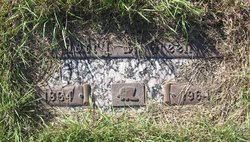
Harry S Green
| Birth | : | 1884 Montana, USA |
| Death | : | 22 May 1964 Rochester, Olmsted County, Minnesota, USA |
| Burial | : | St Mary's Cemetery, Taunton, Taunton Deane Borough, England |
| Coordinate | : | 51.0145110, -3.1208470 |
| Description | : | The following provided by Find A Grave contributor "Cara": Great Falls Tribune (MT), 24 May 1964 Harry Green, Big Sandy Rancher, Dies at Rochester Harry Green, 79, prominent Big Sandy cattle rancher, and early day Montana rodeo rider and cowpuncher, died Friday at Rochester, Minn., where he had undergone surgery. Green was born in 1884 at old Fort McGinnis in Montana territory, the son of Hugh Hamilton Green, captain of the cavalry there. He attended school at Gilt Edge and first worked as a horse wrangler for the 2-Bar ranch. He punched cattle during the big Judith Basin roundups... Read More |
frequently asked questions (FAQ):
-
Where is Harry S Green's memorial?
Harry S Green's memorial is located at: St Mary's Cemetery, Taunton, Taunton Deane Borough, England.
-
When did Harry S Green death?
Harry S Green death on 22 May 1964 in Rochester, Olmsted County, Minnesota, USA
-
Where are the coordinates of the Harry S Green's memorial?
Latitude: 51.0145110
Longitude: -3.1208470
Family Members:
Spouse
Flowers:


Nearby Cemetories:
1. St Mary's Cemetery
Taunton, Taunton Deane Borough, England
Coordinate: 51.0145110, -3.1208470
2. St. Mary's Old Cemetery
Taunton, Taunton Deane Borough, England
Coordinate: 51.0152400, -3.1212100
3. Taunton Deane Crematorium
Taunton, Taunton Deane Borough, England
Coordinate: 51.0099290, -3.1328370
4. Taunton Prison Cemetery
Taunton, Taunton Deane Borough, England
Coordinate: 51.0119040, -3.1074170
5. Ss Peter and Paul Churchyard
Bishops Hull, Taunton Deane Borough, England
Coordinate: 51.0166220, -3.1350170
6. St James Cemetery
Taunton, Taunton Deane Borough, England
Coordinate: 51.0227000, -3.1136000
7. St. George Churchyard
Wilton, Taunton Deane Borough, England
Coordinate: 51.0090900, -3.1069000
8. St James Churchyard
Taunton, Taunton Deane Borough, England
Coordinate: 51.0177320, -3.1012480
9. St. Mary Magdalene Church
Taunton, Taunton Deane Borough, England
Coordinate: 51.0157120, -3.1006450
10. United Reformed Church
Taunton, Taunton Deane Borough, England
Coordinate: 51.0130240, -3.0997408
11. St. George's Roman Catholic Church
Taunton Deane Borough, England
Coordinate: 51.0130135, -3.0986681
12. Taunton Priory of St Peter and St Paul
Taunton, Taunton Deane Borough, England
Coordinate: 51.0188270, -3.0988810
13. St John the Evangelist Churchyard
Staplegrove, Taunton Deane Borough, England
Coordinate: 51.0318720, -3.1248960
14. All Saints Churchyard
Trull, Taunton Deane Borough, England
Coordinate: 50.9937770, -3.1180660
15. All Saints Churchyard
Norton Fitzwarren, Taunton Deane Borough, England
Coordinate: 51.0279030, -3.1468510
16. St Michael's Churchyard
Orchard Portman, Taunton Deane Borough, England
Coordinate: 50.9893670, -3.0788890
17. St Mary Churchyard
Cheddon Fitzpaine, Taunton Deane Borough, England
Coordinate: 51.0426420, -3.0811930
18. St Giles Churchyard
Bradford-on-Tone, Taunton Deane Borough, England
Coordinate: 51.0002460, -3.1799410
19. Holy Cross at Hillfarrance
Wellington, Taunton Deane Borough, England
Coordinate: 51.0150260, -3.1884860
20. Ruishton Church Cemetery
Ruishton, Taunton Deane Borough, England
Coordinate: 51.0204630, -3.0520420
21. St. George Churchyard
Ruishton, Taunton Deane Borough, England
Coordinate: 51.0206300, -3.0511400
22. St. Nicholas's Churchyard
Corfe, Taunton Deane Borough, England
Coordinate: 50.9714590, -3.0947100
23. Blessed Virgin Mary Churchyard
Kingston St Mary, Taunton Deane Borough, England
Coordinate: 51.0610300, -3.1104300
24. SS Andrew and Mary Churchyard
Pitminster, Taunton Deane Borough, England
Coordinate: 50.9663940, -3.1107440