
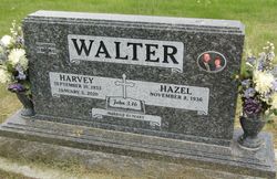

Harvey Leroy Walter
| Birth | : | 10 Sep 1933 Billings, Yellowstone County, Montana, USA |
| Death | : | 5 Jan 2020 Forsyth, Rosebud County, Montana, USA |
| Burial | : | Forsyth Cemetery, Forsyth, Rosebud County, USA |
| Coordinate | : | 46.2689018, -106.6528015 |
| Inscription | : | John #-16 Married 61 years |
| Description | : | SOURCE: Death Certificate: ''''''''''''''''''''' Source: Stevenson and Sons Funeral Home Harvey L. Walter, a longtime Forsyth-area farmer-rancher, passed to heaven on January 5. He was 86. Harvey was born on September 10, 1933, on his grandparents' farm west of Billings, the first of George and Rachel Walter's six children. Harvey was baptized at the German Congregational Church, grew up on the family farm on Hesper Road, and attended Elder Grove school. Harvey served in the U.S. Army 27th Infantry Division as a combat engineer beginning in 1954, stationed first in California and then... Read More |
frequently asked questions (FAQ):
-
Where is Harvey Leroy Walter's memorial?
Harvey Leroy Walter's memorial is located at: Forsyth Cemetery, Forsyth, Rosebud County, USA.
-
When did Harvey Leroy Walter death?
Harvey Leroy Walter death on 5 Jan 2020 in Forsyth, Rosebud County, Montana, USA
-
Where are the coordinates of the Harvey Leroy Walter's memorial?
Latitude: 46.2689018
Longitude: -106.6528015
Family Members:
Parent

Siblings
Children
Flowers:


Nearby Cemetories:
1. Forsyth Cemetery
Forsyth, Rosebud County, USA
Coordinate: 46.2689018, -106.6528015
2. Rosebud Cemetery
Rosebud, Rosebud County, USA
Coordinate: 46.2689018, -106.4381027
3. Howard Cemetery
Rosebud County, USA
Coordinate: 46.2621994, -106.9222031
4. Hathaway Cemetery
Rosebud County, USA
Coordinate: 46.2616997, -106.2185974
5. Colstrip Cemetery
Colstrip, Rosebud County, USA
Coordinate: 45.9096985, -106.6194000
6. Memorial Vale Cemetery
Hysham, Treasure County, USA
Coordinate: 46.2552986, -107.2307968
7. Bean Cemetery
Rosebud County, USA
Coordinate: 45.8535995, -106.4011002
8. Brown Cemetery
Colstrip, Rosebud County, USA
Coordinate: 45.8321991, -106.4180984
9. Lee Cemetery
Rosebud County, USA
Coordinate: 45.7792015, -106.5413971
10. Rancher Cemetery
Myers, Treasure County, USA
Coordinate: 46.2580986, -107.4197006
11. Fort Keogh Cemetery
Custer County, USA
Coordinate: 46.3800011, -105.8874969
12. Vanstel Cemetery
Rosebud County, USA
Coordinate: 46.7872009, -106.8942032
13. Calvary Cemetery
Miles City, Custer County, USA
Coordinate: 46.3816986, -105.8249969
14. Eastern Montana State Veterans Cemetery
Miles City, Custer County, USA
Coordinate: 46.3807564, -105.8246536
15. Old Calvary Cemetery
Miles City, Custer County, USA
Coordinate: 46.3807600, -105.8246500
16. Custer County Cemetery
Miles City, Custer County, USA
Coordinate: 46.3891983, -105.8264008
17. Pine Hills School Cemetery
Miles City, Custer County, USA
Coordinate: 46.4077988, -105.8167038
18. Rock Springs Cemetery
Rock Springs, Rosebud County, USA
Coordinate: 46.7847800, -106.1411500
19. Pine Crest Cemetery
Custer County, USA
Coordinate: 46.4564018, -105.7789001
20. Junction City Cemetery
Yellowstone County, USA
Coordinate: 46.1437320, -107.5493300
21. Lame Deer Cemetery
Lame Deer, Rosebud County, USA
Coordinate: 45.6264000, -106.6619034
22. Custer Cemetery
Custer, Yellowstone County, USA
Coordinate: 46.1270690, -107.5700030
23. Muddy Creek Cemetery
Muddy, Big Horn County, USA
Coordinate: 45.5741997, -106.7406006
24. Saint Labre Cemetery
Ashland, Rosebud County, USA
Coordinate: 45.6070930, -106.2836910