
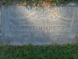
Hattie May McNabb Niegel
| Birth | : | 31 Jan 1888 Friendship, Adams County, Wisconsin, USA |
| Death | : | 31 Oct 1978 Auburn, Placer County, California, USA |
| Burial | : | Canfield Village Cemetery, Canfield, Mahoning County, USA |
| Coordinate | : | 41.0242830, -80.7536270 |
| Plot | : | 545 2-8 |
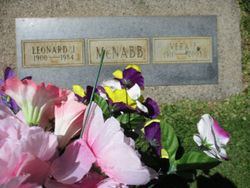
| Inscription | : | Hattie M. Niegel 1888 1978 |
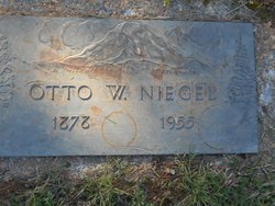
| Description | : | Funeral services will be held today at 10:30 a.m. at the Chapel of the Hills, Auburn, for Hattie May Niegel, 90. Burial will be in the family plot in the Old Auburn District Cemetery. Mrs. Niegel died Tuesday in an Auburn hospital. She was a native of Friendship, Wis.,and had lived in Cool, El Dorado County, for the past 89 years. She was the wife of the late Otto W. Niegel, who was a rancher in Cool for many years. Surviving are a son, Delbert Niegel of Cool; a brother, Leonard McNabb of Auburn; a grandchild and three great grandchildren. |
frequently asked questions (FAQ):
-
Where is Hattie May McNabb Niegel's memorial?
Hattie May McNabb Niegel's memorial is located at: Canfield Village Cemetery, Canfield, Mahoning County, USA.
-
When did Hattie May McNabb Niegel death?
Hattie May McNabb Niegel death on 31 Oct 1978 in Auburn, Placer County, California, USA
-
Where are the coordinates of the Hattie May McNabb Niegel's memorial?
Latitude: 41.0242830
Longitude: -80.7536270
Family Members:
Parent
Spouse
Siblings


Nearby Cemetories:
1. Canfield Village Cemetery
Canfield, Mahoning County, USA
Coordinate: 41.0242830, -80.7536270
2. Old North Cemetery
Canfield, Mahoning County, USA
Coordinate: 41.0393982, -80.7600021
3. Infirmary Cemetery
Canfield, Mahoning County, USA
Coordinate: 41.0482500, -80.7792950
4. Dean Hill Cemetery
Canfield, Mahoning County, USA
Coordinate: 41.0353012, -80.7957993
5. Green Haven Memorial Gardens
Canfield, Mahoning County, USA
Coordinate: 41.0625340, -80.7594670
6. Pet Haven Memorial Gardens
Canfield, Mahoning County, USA
Coordinate: 41.0647840, -80.7579190
7. Paradise Lutheran Cemetery
Canfield, Mahoning County, USA
Coordinate: 40.9872800, -80.7203500
8. Smith Corners Cemetery
Austintown, Mahoning County, USA
Coordinate: 41.0689011, -80.7613983
9. Sharethora Cemetery
Mahoning County, USA
Coordinate: 41.0567017, -80.7121964
10. Boardman Zion Cemetery
Boardman, Mahoning County, USA
Coordinate: 41.0566700, -80.7106730
11. Ohev Tzedek Cemetery
Canfield, Mahoning County, USA
Coordinate: 41.0607986, -80.7118988
12. Cornersburg Cemetery
Cornersburg, Mahoning County, USA
Coordinate: 41.0608900, -80.7117400
13. Calla Cemetery
Calla, Mahoning County, USA
Coordinate: 40.9727600, -80.7716800
14. Saint Pauls Monastery Cemetery
Canfield, Mahoning County, USA
Coordinate: 41.0228160, -80.8288300
15. Dutch Ridge Cemetery
Green Township, Mahoning County, USA
Coordinate: 40.9835130, -80.8145550
16. Paradise Cemetery
North Lima, Mahoning County, USA
Coordinate: 40.9728369, -80.7061874
17. Cool Family Cemetery
Greenford, Mahoning County, USA
Coordinate: 40.9641100, -80.7815880
18. Covenanter Cemetery
North Jackson, Mahoning County, USA
Coordinate: 41.0687270, -80.8201110
19. Rider Farm Cemetery
Youngstown, Mahoning County, USA
Coordinate: 41.0744930, -80.6937680
20. Forest Lawn Memorial Park Cemetery
Boardman Township, Mahoning County, USA
Coordinate: 41.0428009, -80.6671982
21. Geeburg Methodist Church Cemetery
Ellsworth, Mahoning County, USA
Coordinate: 41.0487850, -80.8380010
22. Old Brunstetter Cemetery
Austintown, Mahoning County, USA
Coordinate: 41.0946007, -80.7788696
23. Ellsworth Cemetery
Ellsworth, Mahoning County, USA
Coordinate: 41.0244700, -80.8510760
24. Brunstetter Cemetery
Austintown, Mahoning County, USA
Coordinate: 41.0957830, -80.7788540