
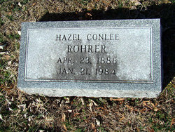
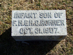
Hazel Conlee Rohrer
| Birth | : | 23 Apr 1886 |
| Death | : | 21 Jan 1984 |
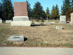
| Burial | : | Mount Olivet Cemetery, Manns Choice, Bedford County, USA |
| Coordinate | : | 40.0219400, -78.5771000 |
| Plot | : | 2nd.206 |
| Description | : | Wife of Fred H Rohrer. |
frequently asked questions (FAQ):
-
Where is Hazel Conlee Rohrer's memorial?
Hazel Conlee Rohrer's memorial is located at: Mount Olivet Cemetery, Manns Choice, Bedford County, USA.
-
When did Hazel Conlee Rohrer death?
Hazel Conlee Rohrer death on 21 Jan 1984 in
-
Where are the coordinates of the Hazel Conlee Rohrer's memorial?
Latitude: 40.0219400
Longitude: -78.5771000
Family Members:
Parent
Spouse

Siblings
Children
Flowers:


Nearby Cemetories:
1. Mount Olivet Cemetery
Manns Choice, Bedford County, USA
Coordinate: 40.0219400, -78.5771000
2. William Frazier Burial Ground
Manns Choice, Bedford County, USA
Coordinate: 40.0140500, -78.6255600
3. Major John Cessna Burial Site
Bedford, Bedford County, USA
Coordinate: 39.9933000, -78.5352000
4. Bedford County Home Cemetery
Bedford Springs, Bedford County, USA
Coordinate: 39.9853000, -78.5456000
5. Mount Ross Cemetery
Bedford, Bedford County, USA
Coordinate: 40.0348854, -78.5220261
6. Saint Thomas the Apostle Catholic Cemetery
Bedford, Bedford County, USA
Coordinate: 40.0173607, -78.5149078
7. German Reformed and Lutheran Church Cemetery
Bedford, Bedford County, USA
Coordinate: 40.0165000, -78.5048500
8. Old Presbyterian Graveyard
Bedford, Bedford County, USA
Coordinate: 40.0153236, -78.5028381
9. Bedford Cemetery
Bedford, Bedford County, USA
Coordinate: 40.0265694, -78.5025024
10. Saint James Episcopal Church Memorial Garden
Bedford, Bedford County, USA
Coordinate: 40.0156170, -78.5012270
11. Old Saint Thomas The Apostle Cemetery
Bedford, Bedford County, USA
Coordinate: 40.0166512, -78.4975662
12. Dry Ridge Lutheran Cemetery
Manns Choice, Bedford County, USA
Coordinate: 39.9876000, -78.6437000
13. Bedford County Memorial Park
Bedford, Bedford County, USA
Coordinate: 40.0539017, -78.5081024
14. Sweet Root Cemetery
Bedford Springs, Bedford County, USA
Coordinate: 39.9728661, -78.5272675
15. Mount Smith Cemetery
Bedford, Bedford County, USA
Coordinate: 40.0703354, -78.5162506
16. Saint Pauls Reformed Church Cemetery
Cessna, Bedford County, USA
Coordinate: 40.0852460, -78.5231280
17. Anderson Cemetery
Cessna, Bedford County, USA
Coordinate: 40.0963060, -78.5330390
18. Saint John's Lutheran Church Cemetery
Cessna, Bedford County, USA
Coordinate: 40.0968300, -78.5251900
19. Burning Bush Cemetery
Burning Bush, Bedford County, USA
Coordinate: 39.9368100, -78.5828700
20. Beaver Lane Cemetery
Cessna, Bedford County, USA
Coordinate: 40.1085106, -78.5497407
21. Trans Run United Methodist Churchyard
Charlesville, Bedford County, USA
Coordinate: 39.9566460, -78.4979706
22. Old Dibert Road Cemetery
Chalybeate, Bedford County, USA
Coordinate: 40.0385600, -78.4627500
23. Hull Baptist Church Cemetery
New Paris, Bedford County, USA
Coordinate: 40.0939000, -78.6476000
24. Christian Light Church Cemetery
Cessna, Bedford County, USA
Coordinate: 40.1039000, -78.5241000