
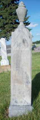
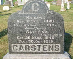
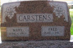
Heinrich “Henry John” Carstens
| Birth | : | 5 Jul 1866 |
| Death | : | 22 Jan 1895 Pierce County, Nebraska, USA |
| Burial | : | Lovelace Baptist Church Cemetery, Greene County, USA |
| Coordinate | : | 36.4009050, -82.6528710 |
| Description | : | Pierce County Call; Pierce Nebraska; 25 January 1895 Met Death in a Well! News was brought to town Tuesday forenoon that while assisting a neighbor to dig a well that forenoon, Henry Carstens, a young farmer living six miles east of Pierce, had been buried by the well caving in. It seems that the well had been put down to the depth of some nineteen feet, and a curb had been made to put in the well but was bout two feet to long. Young Carstens was cautioned on the dangers of going down again until the curb had been put in,... Read More |
frequently asked questions (FAQ):
-
Where is Heinrich “Henry John” Carstens's memorial?
Heinrich “Henry John” Carstens's memorial is located at: Lovelace Baptist Church Cemetery, Greene County, USA.
-
When did Heinrich “Henry John” Carstens death?
Heinrich “Henry John” Carstens death on 22 Jan 1895 in Pierce County, Nebraska, USA
-
Where are the coordinates of the Heinrich “Henry John” Carstens's memorial?
Latitude: 36.4009050
Longitude: -82.6528710
Family Members:
Parent

Spouse
Siblings

Children
Flowers:


Nearby Cemetories:
1. Lovelace Baptist Church Cemetery
Greene County, USA
Coordinate: 36.4009050, -82.6528710
2. Chimney Top Free Will Baptist Church Cemetery
Greene County, USA
Coordinate: 36.4034380, -82.6859110
3. Baines Cemetery
Washington County, USA
Coordinate: 36.4105988, -82.6175003
4. Fall Branch First Baptist Church Cemetery
Fall Branch, Washington County, USA
Coordinate: 36.4174995, -82.6213989
5. Fall Branch United Methodist Church Cemetery
Fall Branch, Washington County, USA
Coordinate: 36.4249992, -82.6299973
6. Haws Cemetery
Washington County, USA
Coordinate: 36.3833008, -82.6166992
7. Landon Carter Hale Cemetery
Fall Branch, Washington County, USA
Coordinate: 36.3694700, -82.6242380
8. Church of Christ Cemetery
Fall Branch, Washington County, USA
Coordinate: 36.3998200, -82.6020500
9. Bethany Free Will Baptist Church Cemetery
Jearoldstown, Greene County, USA
Coordinate: 36.3751490, -82.6964110
10. Bethesda Cumberland Presbyterian Church Cemetery
Greene County, USA
Coordinate: 36.3572000, -82.6580000
11. Kincheloe-Hooper Cemetery
Fall Branch, Washington County, USA
Coordinate: 36.3842010, -82.6014023
12. Logans Chapel Cemetery
Fall Branch, Washington County, USA
Coordinate: 36.3903008, -82.5955963
13. Gibson Cemetery
Washington County, USA
Coordinate: 36.4122009, -82.5924988
14. Carr-Whetsel Cemetery
Fall Branch, Sullivan County, USA
Coordinate: 36.4502600, -82.6626300
15. Solomon’s Temple Missionary Baptist Cemetery
Blair Gap, Sullivan County, USA
Coordinate: 36.4506600, -82.6776700
16. Chimney Top Cemetery
Jearoldstown, Greene County, USA
Coordinate: 36.4064429, -82.7196623
17. Crawford Cemetery
Kingsport, Sullivan County, USA
Coordinate: 36.4521640, -82.6780350
18. Light Cemetery
Kingsport, Sullivan County, USA
Coordinate: 36.4496470, -82.6872370
19. Murray Cemetery
Kingsport, Sullivan County, USA
Coordinate: 36.4534960, -82.6797580
20. Mill Creek Baptist Church Cemetery
Fall Branch, Sullivan County, USA
Coordinate: 36.4351220, -82.5951530
21. Steadman Cemetery
Sullivan Gardens, Sullivan County, USA
Coordinate: 36.4277992, -82.5894012
22. Murrell Family Cemetery
Sullivan Gardens, Sullivan County, USA
Coordinate: 36.4557900, -82.6299800
23. Fulkerson Cemetery
Washington County, USA
Coordinate: 36.4117012, -82.5766983
24. Mullins Cemetery
Sullivan Gardens, Sullivan County, USA
Coordinate: 36.4639143, -82.6546705