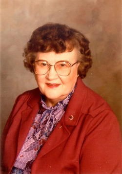
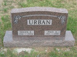
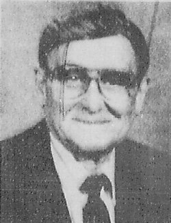
Helen Edith May Peterson Urban
| Birth | : | 8 May 1914 Weta, Jackson County, South Dakota, USA |
| Death | : | 24 Feb 2004 Philip, Haakon County, South Dakota, USA |
| Burial | : | Franktown Cemetery, Franktown, Northampton County, USA |
| Coordinate | : | 37.4825730, -75.8829810 |
| Plot | : | H-13 |
| Description | : | Helen Edith May Peterson was born May 8, 1914 on a farm in the Weta area, the daughter of Jacob and Alma Sophia (Spong) Peterson. She grew up in the Weta area and graduated from Weta High School. As a young lady she worked for restaurants in the Kadoka and Philip areas. Helen was united in marriage to Paul A. Urban on April 27, 1940 at Rapid City, South Dakota. They made their home in Philip until 1941 when they moved to Long Beach, California where Paul worked in the shipyards during WWII. They returned to Philip... Read More |
frequently asked questions (FAQ):
-
Where is Helen Edith May Peterson Urban's memorial?
Helen Edith May Peterson Urban's memorial is located at: Franktown Cemetery, Franktown, Northampton County, USA.
-
When did Helen Edith May Peterson Urban death?
Helen Edith May Peterson Urban death on 24 Feb 2004 in Philip, Haakon County, South Dakota, USA
-
Where are the coordinates of the Helen Edith May Peterson Urban's memorial?
Latitude: 37.4825730
Longitude: -75.8829810
Family Members:
Parent
Spouse
Siblings
Flowers:
Nearby Cemetories:
1. Franktown Cemetery
Franktown, Northampton County, USA
Coordinate: 37.4825730, -75.8829810
2. Bethel Memorial Gardens
Franktown, Northampton County, USA
Coordinate: 37.4764470, -75.8844710
3. Gunter Farm Cemetery
Franktown, Northampton County, USA
Coordinate: 37.4835580, -75.8930290
4. New Allen Memorial AME Church Cemetery
Franktown, Northampton County, USA
Coordinate: 37.4837330, -75.8679440
5. Sturgis Family Cemetery
Franktown, Northampton County, USA
Coordinate: 37.4735700, -75.8947300
6. Fatherly Farm Cemetery
Weirwood, Northampton County, USA
Coordinate: 37.4599990, -75.8695450
7. Badger Graveyard
Marionville, Northampton County, USA
Coordinate: 37.4607160, -75.8553050
8. Red Bank Baptist Church Cemetery
Marionville, Northampton County, USA
Coordinate: 37.4519840, -75.8560380
9. Liberty Hall Cemetery
Marionville, Northampton County, USA
Coordinate: 37.4536270, -75.8518210
10. Dunton Family Cemetery
Exmore, Northampton County, USA
Coordinate: 37.5208800, -75.8571000
11. Hungars Episcopal Church Cemetery
Bridgetown, Northampton County, USA
Coordinate: 37.4466940, -75.9240290
12. Tankard Rest Cemetery
Hadlock, Northampton County, USA
Coordinate: 37.5163530, -75.8339200
13. Shorter's Chapel A.M.E. Church Cemetery
Machipongo, Northampton County, USA
Coordinate: 37.4444800, -75.9275970
14. Antioch Baptist Church Cemetery
Treherneville, Northampton County, USA
Coordinate: 37.4291170, -75.8931400
15. Hadlock Burial Ground
Exmore, Northampton County, USA
Coordinate: 37.5197500, -75.8323600
16. Ebenezer Baptist Church Cemetery
Wardtown, Northampton County, USA
Coordinate: 37.5361170, -75.8613830
17. Holy Unity Commandment Church of God Cemetery
Treherneville, Northampton County, USA
Coordinate: 37.4258980, -75.8924850
18. Pearson Lot
Birdsnest, Northampton County, USA
Coordinate: 37.4262100, -75.8683600
19. Johnson's United Methodist Church Cemetery
Machipongo, Northampton County, USA
Coordinate: 37.4270870, -75.9154820
20. Epworth Methodist Church Cemetery
Exmore, Northampton County, USA
Coordinate: 37.5222430, -75.8142650
21. Sturgis Burial Plot
Craddockville, Accomack County, USA
Coordinate: 37.5540000, -75.8820000
22. Old Bell Plot
Painter, Accomack County, USA
Coordinate: 37.5130000, -75.7960000
23. White Plot Upshurs Neck
Quinby, Accomack County, USA
Coordinate: 37.4870000, -75.7860000
24. Mount Pleasant Cemetery
Belle Haven, Accomack County, USA
Coordinate: 37.5560000, -75.8500000


