
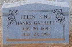
Helen Elizabeth Hanks King Garrett
| Birth | : | 30 Aug 1890 South Carolina, USA |
| Death | : | 27 Jul 1984 South Carolina, USA |
| Burial | : | Oak Mound Cemetery, Healdsburg, Sonoma County, USA |
| Coordinate | : | 38.6164017, -122.8578033 |
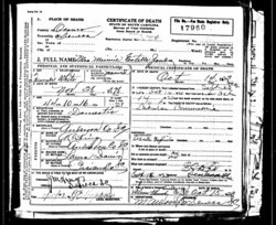
| Description | : | WESTMINSTER--- Helen Elizabeth King Hanks Garrett, 93, of Walhalla Highway died Friday. She was a retired Southern Bell Telephone Co. switchboard operator and was a member of Westminster Baptist Church. She was first married to the late Christian Volentine Hanks and then to the late Robert Stewart Garrett. She was the last surviving member of her immediate family. Surviving are two grandchildren. Services: 11 a.m. Monday at the Sandifer Funeral Home Chapel with burial in Salem Baptist Church Cemetery near Anderson. |
frequently asked questions (FAQ):
-
Where is Helen Elizabeth Hanks King Garrett's memorial?
Helen Elizabeth Hanks King Garrett's memorial is located at: Oak Mound Cemetery, Healdsburg, Sonoma County, USA.
-
When did Helen Elizabeth Hanks King Garrett death?
Helen Elizabeth Hanks King Garrett death on 27 Jul 1984 in South Carolina, USA
-
Where are the coordinates of the Helen Elizabeth Hanks King Garrett's memorial?
Latitude: 38.6164017
Longitude: -122.8578033
Family Members:
Parent
Spouse


Siblings
Children
Flowers:


Nearby Cemetories:
1. Oak Mound Cemetery
Healdsburg, Sonoma County, USA
Coordinate: 38.6164017, -122.8578033
2. Hall Cemetery
Healdsburg, Sonoma County, USA
Coordinate: 38.6610000, -122.8600006
3. Long Ranch Family Cemetery
Geyserville, Sonoma County, USA
Coordinate: 38.6728320, -122.8812540
4. Beeson Cemetery
Geyserville, Sonoma County, USA
Coordinate: 38.6810990, -122.8335000
5. Alexander Family Cemetery
Healdsburg, Sonoma County, USA
Coordinate: 38.6565080, -122.7854350
6. Pioneer Cemetery
Windsor, Sonoma County, USA
Coordinate: 38.5624500, -122.7769700
7. Shiloh Cemetery
Windsor, Sonoma County, USA
Coordinate: 38.5256004, -122.8142014
8. Santa Rosa Memorial Park Shiloh Annex
Windsor, Sonoma County, USA
Coordinate: 38.5247993, -122.8143005
9. Olive Hill Cemetery
Geyserville, Sonoma County, USA
Coordinate: 38.7083015, -122.9231033
10. McPeak Cemetery
Hacienda, Sonoma County, USA
Coordinate: 38.5097008, -122.9272003
11. McPeak Cemetery
Forestville, Sonoma County, USA
Coordinate: 38.5098190, -122.9280929
12. Faught Cemetery
Santa Rosa, Sonoma County, USA
Coordinate: 38.5186005, -122.7574005
13. Mark West Cemetery
Santa Rosa, Sonoma County, USA
Coordinate: 38.5482830, -122.7229580
14. Evergreen Cemetery
Kellogg, Sonoma County, USA
Coordinate: 38.6357002, -122.6802979
15. Fulton Cemetery
Fulton, Sonoma County, USA
Coordinate: 38.4888000, -122.7786026
16. Forestview Cemetery
Forestville, Sonoma County, USA
Coordinate: 38.4677010, -122.8834000
17. Redwood Memorial Gardens
Guerneville, Sonoma County, USA
Coordinate: 38.5071983, -122.9927979
18. Sharp Creek Cemetery
Santa Rosa, Sonoma County, USA
Coordinate: 38.5505981, -122.6713028
19. MHR Redwood Grove Memorial
Calistoga, Napa County, USA
Coordinate: 38.5674930, -122.6536530
20. Steele Family Cemetery
Santa Rosa, Sonoma County, USA
Coordinate: 38.4523730, -122.8065610
21. Green Valley Cemetery
Sebastopol, Sonoma County, USA
Coordinate: 38.4424019, -122.8869019
22. Catron Cemetery
Santa Rosa, Sonoma County, USA
Coordinate: 38.4796982, -122.7083969
23. Gilliam Cemetery
Graton, Sonoma County, USA
Coordinate: 38.4314995, -122.8816986
24. Saint Catherines Church Cemetery
Monte Rio, Sonoma County, USA
Coordinate: 38.4691010, -123.0104980