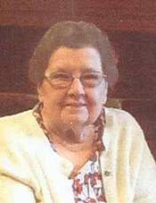
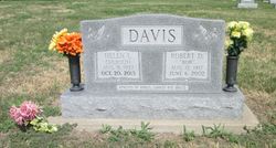
Helen Irene Siebold Davis
| Birth | : | 9 Aug 1927 Clay County, Kansas, USA |
| Death | : | 20 Oct 2013 Hutchinson, Reno County, Kansas, USA |
| Burial | : | Morganville City Cemetery, Morganville, Clay County, USA |
| Coordinate | : | 39.4733009, -97.1819000 |
| Inscription | : | PARENTS OF KAREN, SHARON AND BRUCE |
| Description | : | HELEN IRENE DAVIS died October 20, 2013 at Wesley Towers, Hutchinson, KS at the age of 86. HELEN IRENE DAVIS was born on August 9, 1927 in Clay County Kansas, the daughter of Albert Siebold and Vena Palmateer. Helen was raised in the Fact Community. She married Ahart Reed in 1946 and they later divorced. She owned and operated in Leonardville, KS. She married Robert Dale Davis on December 11, 1964 in Manhattan, KS and he preceded her on June 6, 2002. She moved to Clay Center in 1955 and owned and operated Southside and Reed's Cafe. She moved to... Read More |
frequently asked questions (FAQ):
-
Where is Helen Irene Siebold Davis's memorial?
Helen Irene Siebold Davis's memorial is located at: Morganville City Cemetery, Morganville, Clay County, USA.
-
When did Helen Irene Siebold Davis death?
Helen Irene Siebold Davis death on 20 Oct 2013 in Hutchinson, Reno County, Kansas, USA
-
Where are the coordinates of the Helen Irene Siebold Davis's memorial?
Latitude: 39.4733009
Longitude: -97.1819000
Family Members:
Parent
Spouse
Siblings
Children
Flowers:
Nearby Cemetories:
1. Morganville City Cemetery
Morganville, Clay County, USA
Coordinate: 39.4733009, -97.1819000
2. Norwegian Lutheran Cemetery
Clay Center, Clay County, USA
Coordinate: 39.5027900, -97.1828200
3. Swedish Evangelical Lutheran Cemetery
Clay County, USA
Coordinate: 39.4911700, -97.1455100
4. Swedish Pleasant Hill Cemetery
Clay Center, Clay County, USA
Coordinate: 39.4735985, -97.1268997
5. Garfield Center Mission Cemetery
Clay Center, Clay County, USA
Coordinate: 39.5243100, -97.1277500
6. Sherman Cemetery
Morganville, Clay County, USA
Coordinate: 39.5316300, -97.2243700
7. Bloom Cemetery
Morganville, Clay County, USA
Coordinate: 39.4519005, -97.2778015
8. Hayes Cemetery
Clay County, USA
Coordinate: 39.4516983, -97.0811005
9. Greenwood Cemetery
Clay Center, Clay County, USA
Coordinate: 39.4011002, -97.1275024
10. Saint Peter and Saint Pauls Catholic Cemetery
Clay Center, Clay County, USA
Coordinate: 39.4005450, -97.1236680
11. Idylwilde Cemetery
Clay Center, Clay County, USA
Coordinate: 39.5097900, -97.0713000
12. Wilson Cemetery
Clay County, USA
Coordinate: 39.3800011, -97.1896973
13. Riverdale Cemetery
Clay County, USA
Coordinate: 39.5106010, -97.2930984
14. Lincoln Cemetery
Clay Center, Clay County, USA
Coordinate: 39.4230995, -97.2930984
15. Brethren in Christ Cemetery
Clay County, USA
Coordinate: 39.4810982, -97.0344009
16. Joseph Sender Family Cemetery
Clay County, USA
Coordinate: 39.5090600, -97.0348800
17. Clay County Poor Farm Cemetery
Clay Center, Clay County, USA
Coordinate: 39.3772700, -97.0727000
18. Republican City Cemetery
Clay Center, Clay County, USA
Coordinate: 39.3431015, -97.1628036
19. Iwacura Cemetery
Morganville, Clay County, USA
Coordinate: 39.4550000, -97.3510000
20. Goshen Central Cemetery
Clay Center, Clay County, USA
Coordinate: 39.5099983, -97.0160980
21. Idana Cemetery
Idana, Clay County, USA
Coordinate: 39.3574500, -97.2693300
22. Fancy Creek Cemetery
Green, Clay County, USA
Coordinate: 39.4668999, -96.9969025
23. Appleton Cemetery
Clay County, USA
Coordinate: 39.5250015, -96.9972000
24. Green Cemetery
Green, Clay County, USA
Coordinate: 39.4235992, -96.9882965


