Helen M Smith Brooks
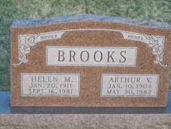
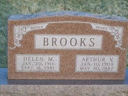
| Birth | : | 20 Jan 1911 Bunker Hill, Miami County, Indiana, USA |
| Death | : | 16 Sep 1981 Wabash, Wabash County, Indiana, USA |
| Burial | : | Hagley Methodist-Uniting Cemetery, Hagley, Meander Valley Council, Australia |
| Coordinate | : | -41.5258094, 146.8881433 |
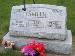
| Description | : | Helen M. Brooks (9-21-1981 Wabash Plain Dealer) Helen M. Brooks, 70, RR3, died at 5 p.m. yesterday in Wabash County Hospital. She had been in failing health six months. She was born Jan. 20, 1911, in Bunker Hill to Pearl and Mary (Benson) Smith. She married Arthur Brooks Sept. 21, 1932, in Wabash. He survives. A housewife, she was a lifelong Wabash County resident. She was a member of the Lebanon Church. Also surviving are two sons, Tony Brooks, Huntington, and David Brooks, Sweetser; two daughters, Mrs. Richard (Mary Jane) Fox, Noblessville, and Mrs. Francis (Joan) Mountain, witchita Falls, Tx; two brothers, James Smith... Read More |
frequently asked questions (FAQ):
-
Where is Helen M Smith Brooks's memorial?
Helen M Smith Brooks's memorial is located at: Hagley Methodist-Uniting Cemetery, Hagley, Meander Valley Council, Australia.
-
When did Helen M Smith Brooks death?
Helen M Smith Brooks death on 16 Sep 1981 in Wabash, Wabash County, Indiana, USA
-
Where are the coordinates of the Helen M Smith Brooks's memorial?
Latitude: -41.5258094
Longitude: 146.8881433
Family Members:
Parent
Spouse
Siblings
Children
Nearby Cemetories:
1. Hagley Methodist-Uniting Cemetery
Hagley, Meander Valley Council, Australia
Coordinate: -41.5258094, 146.8881433
2. Hagley Presbyterian Cemetery
Hagley, Meander Valley Council, Australia
Coordinate: -41.5255610, 146.8975560
3. St. Mary's Anglican Church Cemetery
Hagley, Meander Valley Council, Australia
Coordinate: -41.5217840, 146.9104460
4. Westbury Pioneer Catholic Cemetery
Westbury, Meander Valley Council, Australia
Coordinate: -41.5333340, 146.8393990
5. Culzean Cemetery
Westbury, Meander Valley Council, Australia
Coordinate: -41.5212380, 146.8339060
6. Westbury Uniting Church Cemetery
Westbury, Meander Valley Council, Australia
Coordinate: -41.5316580, 146.8318780
7. Westbury General Cemetery
Westbury, Meander Valley Council, Australia
Coordinate: -41.5319850, 146.8259020
8. Whitemore Methodist-Uniting Cemetery
Whitemore, Meander Valley Council, Australia
Coordinate: -41.5810490, 146.9325240
9. Carrick Anglican Churchyard
Carrick, Meander Valley Council, Australia
Coordinate: -41.5306800, 147.0075400
10. Holy Nativity Anglican Cemetery
Bishopsbourne, Northern Midlands Council, Australia
Coordinate: -41.6173490, 146.9869290
11. Bracknell General Cemetery
Bracknell, Meander Valley Council, Australia
Coordinate: -41.6436630, 146.9398520
12. Church Of The Good Shepherd
Hadspen, Meander Valley Council, Australia
Coordinate: -41.5076150, 147.0618590
13. Bracknell Presbyterian Cemetery
Bracknell, Meander Valley Council, Australia
Coordinate: -41.6518889, 146.9420278
14. Hadspen Uniting Church Cemetery
Hadspen, Meander Valley Council, Australia
Coordinate: -41.5064200, 147.0637300
15. Illawarra Christ Church Cemetery
Carrick, Meander Valley Council, Australia
Coordinate: -41.5502380, 147.0651810
16. Mountain Vale Methodist Cemetery
Liffey, Northern Midlands Council, Australia
Coordinate: -41.6728910, 146.8919670
17. Saint Mark's Anglican Cemetery
Deloraine, Meander Valley Council, Australia
Coordinate: -41.5250850, 146.6600750
18. Frankford Cemetery
Frankford, West Tamar Council, Australia
Coordinate: -41.3611110, 146.8022220
19. St Augustine Catholic Church Cemetery
Longford, Northern Midlands Council, Australia
Coordinate: -41.5932650, 147.1140900
20. Longford Christ Church Pioneer Cemetery
Longford, Northern Midlands Council, Australia
Coordinate: -41.5943270, 147.1194860
21. Prospect Vale Congregational Cemetery
Prospect Vale, Meander Valley Council, Australia
Coordinate: -41.4751150, 147.1275000
22. Longford General Cemetery
Longford, Northern Midlands Council, Australia
Coordinate: -41.6223790, 147.1055480
23. Longford Uniting Church Cemetery
Longford, Northern Midlands Council, Australia
Coordinate: -41.6096150, 147.1162410
24. St. Canice Catholic Cemetery
Glengarry, West Tamar Council, Australia
Coordinate: -41.3350250, 146.8701150

