
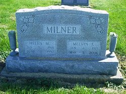
Helen Maxine Johnson Milner
| Birth | : | 31 Jan 1918 Centerville, Appanoose County, Iowa, USA |
| Death | : | 1 Jun 1997 Appanoose County, Iowa, USA |
| Burial | : | Silver Lake Cemetery, Athol, Worcester County, USA |
| Coordinate | : | 42.6018982, -72.2249985 |
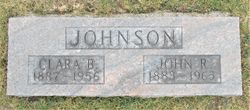
| Description | : | The wife of Melvin Milner. They were united in marriage on March 15, 1936 in Unionville, Missouri. Helen was the daughter of John Johnson and Clara Holman Johnson. |
frequently asked questions (FAQ):
-
Where is Helen Maxine Johnson Milner's memorial?
Helen Maxine Johnson Milner's memorial is located at: Silver Lake Cemetery, Athol, Worcester County, USA.
-
When did Helen Maxine Johnson Milner death?
Helen Maxine Johnson Milner death on 1 Jun 1997 in Appanoose County, Iowa, USA
-
Where are the coordinates of the Helen Maxine Johnson Milner's memorial?
Latitude: 42.6018982
Longitude: -72.2249985
Family Members:
Parent

Spouse

Siblings
Flowers:


Nearby Cemetories:
1. Silver Lake Cemetery
Athol, Worcester County, USA
Coordinate: 42.6018982, -72.2249985
2. Old Burial Ground
Athol, Worcester County, USA
Coordinate: 42.5889840, -72.2270420
3. Mount Pleasant Cemetery
Athol, Worcester County, USA
Coordinate: 42.5943985, -72.2433014
4. Highland Cemetery
Athol, Worcester County, USA
Coordinate: 42.5889015, -72.2110977
5. Old Pleasant Street Cemetery
Athol, Worcester County, USA
Coordinate: 42.5860800, -72.2145100
6. Calvary Cemetery
Athol, Worcester County, USA
Coordinate: 42.5842018, -72.2117004
7. Chestnut Hill Cemetery
Athol, Worcester County, USA
Coordinate: 42.6296997, -72.2042007
8. Gethsemane Cemetery
Athol, Worcester County, USA
Coordinate: 42.5791960, -72.2578310
9. Jones Cemetery
Orange, Franklin County, USA
Coordinate: 42.6148224, -72.2728806
10. Tully Cemetery
Orange, Franklin County, USA
Coordinate: 42.6398000, -72.2504700
11. Ellinwood Cemetery
Athol, Worcester County, USA
Coordinate: 42.5589400, -72.2142600
12. North Orange Cemetery
Orange, Franklin County, USA
Coordinate: 42.6360230, -72.2690530
13. Maple Cemetery
Royalston, Worcester County, USA
Coordinate: 42.6545520, -72.2235460
14. Fay Cemetery
Athol, Worcester County, USA
Coordinate: 42.5466300, -72.2364200
15. Adams Road Cemetery
Athol, Worcester County, USA
Coordinate: 42.5425560, -72.2133610
16. Central Cemetery
Orange, Franklin County, USA
Coordinate: 42.5932960, -72.3066420
17. Stratton Cemetery
Athol, Worcester County, USA
Coordinate: 42.5407872, -72.2151265
18. New Sherborn Cemetery
Athol, Worcester County, USA
Coordinate: 42.5402985, -72.2166977
19. Riverside Cemetery
Royalston, Worcester County, USA
Coordinate: 42.6302986, -72.1453018
20. Nahum Greene Gravesite
Royalston, Worcester County, USA
Coordinate: 42.6545700, -72.1712900
21. South Cemetery
Orange, Franklin County, USA
Coordinate: 42.5657880, -72.3043410
22. Old Centre Cemetery
Royalston, Worcester County, USA
Coordinate: 42.6713982, -72.1889038
23. Lower Cemetery
Phillipston, Worcester County, USA
Coordinate: 42.5583000, -72.1425018
24. Harvard Cemetery
Petersham, Worcester County, USA
Coordinate: 42.5305000, -72.1896100