
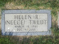
Helen Ruth Neece Twedt
| Birth | : | 18 Mar 1941 Hugo, Choctaw County, Oklahoma, USA |
| Death | : | 9 Dec 2001 Chester, Liberty County, Montana, USA |
| Burial | : | Mount Hope Cemetery, Independence, Montgomery County, USA |
| Coordinate | : | 37.2413300, -95.7060050 |
| Description | : | Great Falls Tribune (MT) - December 12, 2001 Helen R. Twedt RUDYARD - Helen Ruth (Neece) Twedt, 60, a homemaker and antique dealer, died of cancer Sunday at a Chester hospital. A memorial service is 11 a.m. Thursday at Our Savior's Lutheran Church in Rudyard, with burial of ashes in Rudyard Cemetery. Rockman Funeral Chapel is in charge of cremation and arrangements. Survivors include her husband, Allen, of Rudyard a son, Ken Twedt of Seeley Lake and Rudyard a daughter, Deb Schmidt of Warren, Minn. and five grandchildren. Additional survivors include a daughter-in-law, Chris Twedt of Seeley Lake and Rudyard... Read More |
frequently asked questions (FAQ):
-
Where is Helen Ruth Neece Twedt's memorial?
Helen Ruth Neece Twedt's memorial is located at: Mount Hope Cemetery, Independence, Montgomery County, USA.
-
When did Helen Ruth Neece Twedt death?
Helen Ruth Neece Twedt death on 9 Dec 2001 in Chester, Liberty County, Montana, USA
-
Where are the coordinates of the Helen Ruth Neece Twedt's memorial?
Latitude: 37.2413300
Longitude: -95.7060050
Family Members:
Spouse


Nearby Cemetories:
1. Mount Hope Cemetery
Independence, Montgomery County, USA
Coordinate: 37.2413300, -95.7060050
2. Calvary Cemetery
Independence, Montgomery County, USA
Coordinate: 37.2486000, -95.7043991
3. Saint Andrews Cemetery
Independence, Montgomery County, USA
Coordinate: 37.2566986, -95.6658020
4. Pratt Cemetery
Montgomery County, USA
Coordinate: 37.2324982, -95.6557999
5. Le Hunt Cemetery
Montgomery County, USA
Coordinate: 37.2744300, -95.7586200
6. Radical Cemetery
Montgomery County, USA
Coordinate: 37.2882996, -95.7416992
7. Bethel Cemetery
Independence, Montgomery County, USA
Coordinate: 37.2761002, -95.6457977
8. Montgomery County Poor Farm Cemetery
Liberty, Montgomery County, USA
Coordinate: 37.1888590, -95.6493690
9. Choteau Cemetery
Independence, Montgomery County, USA
Coordinate: 37.3194700, -95.6746700
10. Harmony Cemetery
Cherryvale, Montgomery County, USA
Coordinate: 37.2324982, -95.5950012
11. Quaker Cemetery
Elk City, Montgomery County, USA
Coordinate: 37.2395900, -95.8243400
12. Thompson Homestead Cemetery
Liberty, Montgomery County, USA
Coordinate: 37.1767000, -95.6183100
13. Krone Cemetery
Montgomery County, USA
Coordinate: 37.3302400, -95.7494600
14. Highland Cemetery
Montgomery County, USA
Coordinate: 37.2092018, -95.8283005
15. Saint Francis Xavier Cemetery
Cherryvale, Montgomery County, USA
Coordinate: 37.2633018, -95.5753021
16. Liberty Cemetery
Liberty, Montgomery County, USA
Coordinate: 37.1581890, -95.6001580
17. Pleasant Dale Cemetery
Cherryvale, Montgomery County, USA
Coordinate: 37.3139700, -95.5860700
18. Parker Cemetery
Montgomery County, USA
Coordinate: 37.2630997, -95.8572006
19. Spring Hill Cemetery
Montgomery County, USA
Coordinate: 37.1235600, -95.6595500
20. Simpson Cemetery
Elk City, Montgomery County, USA
Coordinate: 37.3269005, -95.8186035
21. Centennial Cemetery
Cherryvale, Montgomery County, USA
Coordinate: 37.2296982, -95.5466995
22. Hinton Cemetery
Liberty, Montgomery County, USA
Coordinate: 37.1384900, -95.6101000
23. Spindletop Cemetery
Cherryvale, Montgomery County, USA
Coordinate: 37.2958400, -95.5570700
24. All Saints Cemetery
Liberty, Montgomery County, USA
Coordinate: 37.1542015, -95.5757980