
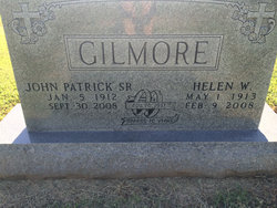
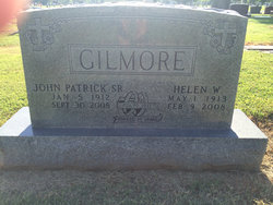
Helen W. Harry Gilmore
| Birth | : | 1 May 1913 Coalvale, Crawford County, Kansas, USA |
| Death | : | 9 Feb 2008 Houston, Harris County, Texas, USA |
| Burial | : | Walnut Grove Cemetery, Elm Store, Randolph County, USA |
| Coordinate | : | 36.4914017, -91.1967010 |
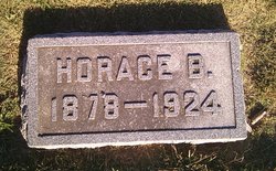
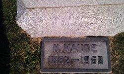
| Description | : | For more info on this family line check out- http://freepages.genealogy.rootsweb.ancestry.com/~marcell/ OBIT- Helen W. Gilmore, 94 of Pittsburg died at 5:50 p.m. Saturday February 9th at the Memorial Hermann Memorial City Hospital in Houston, Texas. She was born to Horace B. and Nellie Maude (Wilson) Harry on May 1, 1913 in Coalvale, KS. Helen attended Pittsburg schools and graduated from Pittsburg High School. She married John Patrick Gilmore on November 20, 1937 in Chicopee, KS. This past November they returned to Pittsburg to celebrate 70 years of marriage with family and friends. The couple lived in many different states in their first years of... Read More |
frequently asked questions (FAQ):
-
Where is Helen W. Harry Gilmore's memorial?
Helen W. Harry Gilmore's memorial is located at: Walnut Grove Cemetery, Elm Store, Randolph County, USA.
-
When did Helen W. Harry Gilmore death?
Helen W. Harry Gilmore death on 9 Feb 2008 in Houston, Harris County, Texas, USA
-
Where are the coordinates of the Helen W. Harry Gilmore's memorial?
Latitude: 36.4914017
Longitude: -91.1967010
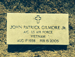
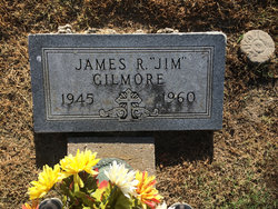
Family Members:
Parent
Spouse
Siblings

Children
Flowers:


Nearby Cemetories:
1. Mount Carmel Cemetery
Calm, Oregon County, USA
Coordinate: 36.5106010, -91.1643982
2. Old Elmore Thomas field
Billmore, Oregon County, USA
Coordinate: 36.5237770, -91.1980250
3. Stubblefield Cemetery
Dalton, Randolph County, USA
Coordinate: 36.4597015, -91.1718979
4. Spring Valley Cemetery
Billmore, Oregon County, USA
Coordinate: 36.5324670, -91.2003420
5. Reynolds Cemetery
Elm Store, Randolph County, USA
Coordinate: 36.4491997, -91.1860962
6. Mosely Cemetery
Randolph County, USA
Coordinate: 36.4460983, -91.1975021
7. Church of God Cemetery
Oregon County, USA
Coordinate: 36.5023500, -91.2580200
8. Bryan Cemetery
Randolph County, USA
Coordinate: 36.4458008, -91.1552963
9. King Cemetery
Randolph County, USA
Coordinate: 36.4357986, -91.1836014
10. Myrtle Cemetery
Myrtle, Oregon County, USA
Coordinate: 36.5133900, -91.2664300
11. Dalton Cemetery
Randolph County, USA
Coordinate: 36.4338989, -91.1496964
12. Coe Cemetery
Warm Springs, Randolph County, USA
Coordinate: 36.4732400, -91.1102200
13. Eaton Cemetery
Randolph County, USA
Coordinate: 36.4185982, -91.1999969
14. New Home Cemetery
Tucker (Gatewood), Ripley County, USA
Coordinate: 36.5112100, -91.1089800
15. Liberty Cemetery
Calm, Oregon County, USA
Coordinate: 36.5586500, -91.1549600
16. Pigman Mound Archeological Site
Calm, Oregon County, USA
Coordinate: 36.5717100, -91.1784800
17. Bailey Cemetery
Dalton, Randolph County, USA
Coordinate: 36.4049225, -91.1895065
18. O'Neal
Billmore, Oregon County, USA
Coordinate: 36.5712170, -91.2415410
19. Upshaw Cemetery
Randolph County, USA
Coordinate: 36.4185982, -91.1207962
20. Hamilton
Warm Springs, Randolph County, USA
Coordinate: 36.4469170, -91.0900830
21. White Cemetery
Randolph County, USA
Coordinate: 36.3939018, -91.1821976
22. Byrd Cemetery
Myrtle, Oregon County, USA
Coordinate: 36.5186005, -91.3143997
23. Bellah Cemetery
Ravenden Springs, Randolph County, USA
Coordinate: 36.4207993, -91.2825012
24. Crass Homestead
Myrtle, Oregon County, USA
Coordinate: 36.5359695, -91.3084671