
| Birth | : | 17 May 1939 Myrtle, Oregon County, Missouri, USA |
| Death | : | 16 Oct 2016 Springfield, Greene County, Missouri, USA |
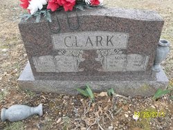
| Burial | : | Byrd Cemetery, Myrtle, Oregon County, USA |
| Coordinate | : | 36.5186005, -91.3143997 |
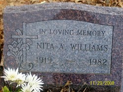
| Description | : | Henry Dale Clark, 77 years of age, of Sparta, Missouri passed from this life on October 16, 2016, at 5:00 AM at Cox South Hospital, Springfield, Missouri. Henry was born May 17, 1939, in Myrtle, Missouri, the ninth child of Georgie B. and Minnie Lucinda ( Williams) Clark. Henry attended Couch School, and Byrd Church. Henry was employed by General Motors Corporation, in Kansas City, Missouri for 24 years. He retired in 1994, relocating in Sparta, Missouri. Henry was a devoted father, and a loving and kind son, brother, uncle, cousin, friend, and neighbor. He invited Christ into his heart, was baptized... Read More |
frequently asked questions (FAQ):
-
Where is Henry Dale Clark's memorial?
Henry Dale Clark's memorial is located at: Byrd Cemetery, Myrtle, Oregon County, USA.
-
When did Henry Dale Clark death?
Henry Dale Clark death on 16 Oct 2016 in Springfield, Greene County, Missouri, USA
-
Where are the coordinates of the Henry Dale Clark's memorial?
Latitude: 36.5186005
Longitude: -91.3143997
Family Members:
Parent

Siblings

Flowers:


Nearby Cemetories:
1. Crass Homestead
Myrtle, Oregon County, USA
Coordinate: 36.5359695, -91.3084671
2. Myrtle Cemetery
Myrtle, Oregon County, USA
Coordinate: 36.5133900, -91.2664300
3. Guiteau-Risner Cemetery
Guiteau, Oregon County, USA
Coordinate: 36.5588074, -91.3156128
4. Church of God Cemetery
Oregon County, USA
Coordinate: 36.5023500, -91.2580200
5. James Cemetery
Randolph County, USA
Coordinate: 36.4660988, -91.3435974
6. Arytown Cemetery
Arytown, Oregon County, USA
Coordinate: 36.5539513, -91.3795776
7. John Brown Cemetery
Jobe, Oregon County, USA
Coordinate: 36.5812111, -91.2953568
8. Garfield Cemetery
Garfield, Oregon County, USA
Coordinate: 36.5844400, -91.3253400
9. Davis Cemetery
Sharp County, USA
Coordinate: 36.4606018, -91.3574982
10. Taylor Cemetery
Ravenden Springs, Randolph County, USA
Coordinate: 36.4468994, -91.3293991
11. Russell Cemetery
Couch, Oregon County, USA
Coordinate: 36.5506477, -91.3991928
12. Cotton Creek Cemetery
Jobe, Oregon County, USA
Coordinate: 36.5844002, -91.2652969
13. O'Neal
Billmore, Oregon County, USA
Coordinate: 36.5712170, -91.2415410
14. Olon Tucker Farm Cemetery #2
Couch, Oregon County, USA
Coordinate: 36.5867000, -91.3705400
15. Wirth Cemetery
Wirth, Sharp County, USA
Coordinate: 36.4522018, -91.3806000
16. Old Jobe Cemetery
Jobe, Oregon County, USA
Coordinate: 36.5917015, -91.2517014
17. Rose Hill Cemetery
Thayer, Oregon County, USA
Coordinate: 36.5186386, -91.4263763
18. Pleasant Ridge Cemetery
Sharp County, USA
Coordinate: 36.4876710, -91.4221830
19. Spring Valley Cemetery
Billmore, Oregon County, USA
Coordinate: 36.5324670, -91.2003420
20. Old Elmore Thomas field
Billmore, Oregon County, USA
Coordinate: 36.5237770, -91.1980250
21. New Salem Cemetery
Couch, Oregon County, USA
Coordinate: 36.6042252, -91.3712463
22. Walnut Grove Cemetery
Elm Store, Randolph County, USA
Coordinate: 36.4914017, -91.1967010
23. Bellah Cemetery
Ravenden Springs, Randolph County, USA
Coordinate: 36.4207993, -91.2825012
24. Roberts Family Farm Cemetery
Couch, Oregon County, USA
Coordinate: 36.6165300, -91.2401700