
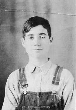
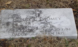
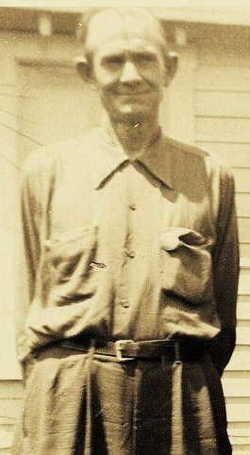
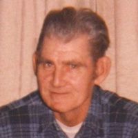
Henry Edward Twomey
| Birth | : | 10 Jun 1927 Bismarck, St. Francois County, Missouri, USA |
| Death | : | 20 Nov 1994 Bonne Terre, St. Francois County, Missouri, USA |
| Burial | : | Omaka Cemetery, Blenheim, Marlborough District, New Zealand |
| Coordinate | : | -41.5381800, 173.9401100 |
| Description | : | Henry Twomey, 67, of Bonne Terre died Nov. 20 at Mineral Area Regional Medical Center. He was born June 10, 1927 in Bismarck to the late Lawrence Adolph and Irene Mayes Twomey. He married (1) Martha Joyce Pettus, 27 Jun 1950; (2) Violet Lee Pullen, 24 Nov 1961; and (3) Opal Lorine Worley, 23 May 1964. He was preceded in death by one grandson and one sister. He is survived by three sons; six daughters; three brothers; five sisters; 10 grandchildren; one great-grandchild; one special friend, Leda Griffith of Glenallen; and nieces and nephews. |
frequently asked questions (FAQ):
-
Where is Henry Edward Twomey's memorial?
Henry Edward Twomey's memorial is located at: Omaka Cemetery, Blenheim, Marlborough District, New Zealand.
-
When did Henry Edward Twomey death?
Henry Edward Twomey death on 20 Nov 1994 in Bonne Terre, St. Francois County, Missouri, USA
-
Where are the coordinates of the Henry Edward Twomey's memorial?
Latitude: -41.5381800
Longitude: 173.9401100
Family Members:
Parent
Spouse
Siblings

Children


Flowers:


Nearby Cemetories:
1. Omaka Cemetery
Blenheim, Marlborough District, New Zealand
Coordinate: -41.5381800, 173.9401100
2. Old Renwick Cemetery
Marlborough District, New Zealand
Coordinate: -41.5014030, 173.8909900
3. Fairhall Cemetery
Blenheim, Marlborough District, New Zealand
Coordinate: -41.5294100, 173.8677800
4. Māori Island Urupā Otamawahu
Grovetown, Marlborough District, New Zealand
Coordinate: -41.4729310, 173.9778908
5. Rapaura Anglican Cemetery
Rapaura, Marlborough District, New Zealand
Coordinate: -41.4719700, 173.9014700
6. Rapaura Community Churchyard
Rapaura, Marlborough District, New Zealand
Coordinate: -41.4724800, 173.8995800
7. Pioneers Church Cemetery
Renwick, Marlborough District, New Zealand
Coordinate: -41.5091139, 173.8364765
8. Te Pokohiwi Urupā
Marlborough District, New Zealand
Coordinate: -41.5068950, 174.0612846
9. Wairau Bar Pilot House Graves
Spring Creek, Marlborough District, New Zealand
Coordinate: -41.4970923, 174.0582651
10. Ruakanakana Urupā
Kaituna, Marlborough District, New Zealand
Coordinate: -41.4463616, 173.8779400
11. Upper Wairau Valley Cemetery
Blenheim, Marlborough District, New Zealand
Coordinate: -41.5171130, 173.7974110
12. Wairau Affray Graves
Tuamarina, Marlborough District, New Zealand
Coordinate: -41.4285146, 173.9597007
13. Tuamarina Cemetery
Tuamarina, Marlborough District, New Zealand
Coordinate: -41.4280969, 173.9623665
14. Kaituna Cemetery
Kaituna, Marlborough District, New Zealand
Coordinate: -41.4694650, 173.8036590
15. Maher Family Cemetery
Kaituna, Marlborough District, New Zealand
Coordinate: -41.4682494, 173.7958289
16. Taylor Pass Cemetery
Seddon, Marlborough District, New Zealand
Coordinate: -41.6706624, 173.9871644
17. Seddon Cemetery
Seddon, Marlborough District, New Zealand
Coordinate: -41.6831810, 174.0582210
18. Langley Dale Cemetery
Marlborough District, New Zealand
Coordinate: -41.5076952, 173.7025647
19. Altimarlock Station
Altimarlock, Marlborough District, New Zealand
Coordinate: -41.7387595, 173.8579141
20. Robin Hood Bay Urupā
Marlborough District, New Zealand
Coordinate: -41.3541665, 174.0768701
21. Ocean Bay
Ocean Bay, Marlborough District, New Zealand
Coordinate: -41.3333300, 174.1000000
22. Kakapo Bay Cemetery
Kakapo Bay, Marlborough District, New Zealand
Coordinate: -41.3240576, 174.1040946
23. Whangatoetoe Bay
Marlborough District, New Zealand
Coordinate: -41.3414261, 174.1410659
24. Picton Gaolyard
Picton, Marlborough District, New Zealand
Coordinate: -41.2933357, 174.0046601