

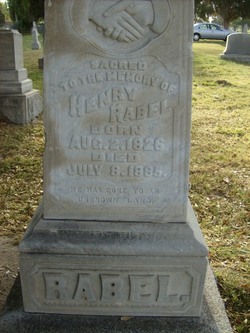
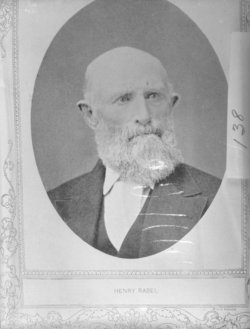
Henry Godfutz Rabel
| Birth | : | 2 Aug 1826 Hanover, Region Hannover, Lower Saxony (Niedersachsen), Germany |
| Death | : | 8 Jul 1885 Los Angeles County, California, USA |
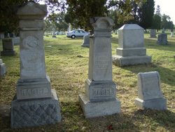
| Burial | : | Eastnor Township Cemetery, Eastnor Township, Bruce County, Canada |
| Coordinate | : | 44.9565200, -81.2648500 |
| Plot | : | block 4-8-7-space 5 |
| Inscription | : | San Bernardino Pioneer plaque |
| Description | : | Came to the United States when he was 18. In the 1880 census he is with his wife Elizabeth and 2 sons in Santa Ana, Los Angeles CO.,CA Built a health resort in San Bernardino near Baseline, west of Victoria. Buying the property from Mormons returning to Salt Lake in 1857.First farming the land and then building bath houses, and finally in 1883, adding a two story hotel for guests to spend the night and take advantage of hot springs on the property, said to have healing powers. He died two years after. |
frequently asked questions (FAQ):
-
Where is Henry Godfutz Rabel's memorial?
Henry Godfutz Rabel's memorial is located at: Eastnor Township Cemetery, Eastnor Township, Bruce County, Canada.
-
When did Henry Godfutz Rabel death?
Henry Godfutz Rabel death on 8 Jul 1885 in Los Angeles County, California, USA
-
Where are the coordinates of the Henry Godfutz Rabel's memorial?
Latitude: 44.9565200
Longitude: -81.2648500
Family Members:
Spouse

Children
Flowers:


Nearby Cemetories:
1. Eastnor Township Cemetery
Eastnor Township, Bruce County, Canada
Coordinate: 44.9565200, -81.2648500
2. Stokes Bay Cemetery
Stokes Bay, Bruce County, Canada
Coordinate: 45.0052299, -81.3674927
3. Red Bay Cemetery
Red Bay, Bruce County, Canada
Coordinate: 44.8015000, -81.2827000
4. Cape Croker St. Mary's First Nations Cemetery
Cape Croker, Bruce County, Canada
Coordinate: 44.9243200, -81.0198100
5. Little Port Elgin First Nations Cemetery
Little Port Elgin, Bruce County, Canada
Coordinate: 44.8880600, -81.0333400
6. Edgehill Cemetery
Wiarton, Bruce County, Canada
Coordinate: 44.7842700, -81.1237200
7. Balsam Grove Cemetery
Oliphant, Bruce County, Canada
Coordinate: 44.7367000, -81.2755000
8. Lucius Albert Burial Site
Oliphant, Bruce County, Canada
Coordinate: 44.7313830, -81.2748130
9. Oxenden Cemetery
Oxenden, Grey County, Canada
Coordinate: 44.7620980, -81.0918510
10. Bayview Cemetery
Wiarton, Bruce County, Canada
Coordinate: 44.7354240, -81.1345901
11. McVicar Cemetery
Saint-Edmunds Township, Bruce County, Canada
Coordinate: 45.1543480, -81.4642900
12. Big Bay Cemetery
Big Bay, Grey County, Canada
Coordinate: 44.7801622, -80.9496850
13. Jackson Cemetery
Amabel Township, Bruce County, Canada
Coordinate: 44.6500000, -81.1928000
14. St Mary's Cemetery
Hepworth, Bruce County, Canada
Coordinate: 44.6317220, -81.1802850
15. Zion Cemetery
Hepworth, Bruce County, Canada
Coordinate: 44.6317600, -81.1795300
16. Boyd Cemetery
Shallow Lake, Grey County, Canada
Coordinate: 44.6257800, -81.1115300
17. French Bay Cemetery
Saugeen Township, Bruce County, Canada
Coordinate: 44.5760020, -81.2835860
18. Dunk's Bay Cemetery
Tobermory, Bruce County, Canada
Coordinate: 45.2489000, -81.6459000
19. Mount Pleasant Cemetery
Georgian Bluffs, Grey County, Canada
Coordinate: 44.6065700, -80.9488100
20. Chippawa Hill Scotch Settlement Sacred Heart Cemet
Chippawa Hill, Bruce County, Canada
Coordinate: 44.5364090, -81.2878540
21. Old Methodist Cemetery
Allenford, Bruce County, Canada
Coordinate: 44.5365900, -81.1742900
22. Leith United Church Cemetery
Leith, Grey County, Canada
Coordinate: 44.6219400, -80.8769500
23. Vanwyck Cemetery
Balaclava, Grey County, Canada
Coordinate: 44.6851090, -80.7755830
24. Menary's Cemetery
Balaclava, Grey County, Canada
Coordinate: 44.6863100, -80.7737990