

Henry Kidwell
| Birth | : | 2 Mar 1808 Pendleton County, Kentucky, USA |
| Death | : | 15 Apr 1875 Crooked Creek, Shelby County, Missouri, USA |
| Burial | : | Good Shepherd Cemetery, Huntington Beach, Orange County, USA |
| Coordinate | : | 33.7022018, -117.9847031 |
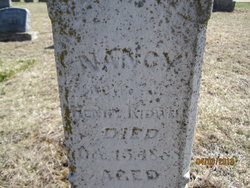
| Description | : | Henry was s/o William Kidwell, Sr. of Stepstone Creek, Pendleton Co., Kentucky. He m. Nancy Mullins, the d/o Fountain Mullins and Mary Turner, both migrants from Grassy Creek, Pendleton Co., Kentucky. They were m. in Marion Co., Missouri where they homesteaded before moving to the Crooked Creek location which was then in Monroe Co., Mo. about 1838. He and his wife, Nancy, were originally buried on the old homestead but later were removed to the Oakridge Baptist Church Cemetery. |
frequently asked questions (FAQ):
-
Where is Henry Kidwell's memorial?
Henry Kidwell's memorial is located at: Good Shepherd Cemetery, Huntington Beach, Orange County, USA.
-
When did Henry Kidwell death?
Henry Kidwell death on 15 Apr 1875 in Crooked Creek, Shelby County, Missouri, USA
-
Where are the coordinates of the Henry Kidwell's memorial?
Latitude: 33.7022018
Longitude: -117.9847031
Family Members:
Spouse
Children

Flowers:

According to my research, you are my great-great grandfather. You were an early settler of Jefferson Township in Shelby Co., Missouri. You lost your right to vote in 1870 because of your Southern proclivities during WBTS. You raised a family of eleven children. I sure would like to make contact with your descendants? Rest in peace Sir. Read less
Left by Anonymous on 10 Nov 2004

Left by Anonymous on 01 Jan 1970

Left by Anonymous on 17 Dec 2013


Nearby Cemetories:
1. Saint Wilfrid of York Episcopal Church Mem Gardens
Huntington Beach, Orange County, USA
Coordinate: 33.6914500, -117.9849200
2. Sea Breeze Pet Cemetery
Huntington Beach, Orange County, USA
Coordinate: 33.6788788, -117.9880829
3. Westminster Memorial Park
Westminster, Orange County, USA
Coordinate: 33.7489014, -117.9931030
4. Harbor Lawn-Mount Olive Memorial Park
Costa Mesa, Orange County, USA
Coordinate: 33.6864624, -117.9242630
5. Magnolia Memorial Park
Garden Grove, Orange County, USA
Coordinate: 33.7843895, -117.9755478
6. Saint James Episcopal Church
Newport Beach, Orange County, USA
Coordinate: 33.6163000, -117.9276300
7. United States Naval Weapons Station Grounds
Seal Beach, Orange County, USA
Coordinate: 33.7505850, -118.0882970
8. Cathedral Memorial Gardens
Garden Grove, Orange County, USA
Coordinate: 33.7880707, -117.8996887
9. Islamic Cemetery
Anaheim, Orange County, USA
Coordinate: 33.7930200, -117.8969800
10. Melrose Abbey Memorial Park
Anaheim, Orange County, USA
Coordinate: 33.7930984, -117.8944016
11. Holy Cross Cemetery
Anaheim, Orange County, USA
Coordinate: 33.8236885, -117.9422226
12. Saint Mark Presbyterian Church Columbarium
Newport Beach, Orange County, USA
Coordinate: 33.6163120, -117.8663090
13. Christ Lutheran Church Columbarium
Long Beach, Los Angeles County, USA
Coordinate: 33.7952500, -118.1044100
14. Fairhaven Memorial Park
Santa Ana, Orange County, USA
Coordinate: 33.7727170, -117.8427780
15. Santa Ana Cemetery
Santa Ana, Orange County, USA
Coordinate: 33.7694016, -117.8388977
16. Saint John's Lutheran Cemetery
Santa Ana, Orange County, USA
Coordinate: 33.7729301, -117.8389282
17. Pacific View Memorial Park
Corona del Mar, Orange County, USA
Coordinate: 33.6088104, -117.8561478
18. Chapman University Columbarium
Orange, Orange County, USA
Coordinate: 33.7924300, -117.8512200
19. Saint Josephs Episcopal Church Columbarium
Buena Park, Orange County, USA
Coordinate: 33.8415590, -118.0280360
20. Forest Lawn Memorial Park
Cypress, Orange County, USA
Coordinate: 33.8339005, -118.0560989
21. Saint Gregory Episcopal Church Columbarium
Long Beach, Los Angeles County, USA
Coordinate: 33.8036100, -118.1105600
22. All Saints Anglican Church Columbarium
Long Beach, Los Angeles County, USA
Coordinate: 33.7696600, -118.1461300
23. Long Beach Police Academy K-9 Cemetery
Long Beach, Los Angeles County, USA
Coordinate: 33.8274000, -118.0895300
24. Saint Pauls Episcopal Memorial Gardens
Tustin, Orange County, USA
Coordinate: 33.7493510, -117.8061190