
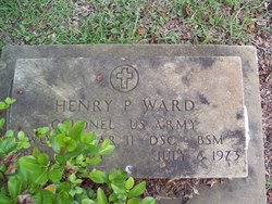
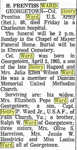
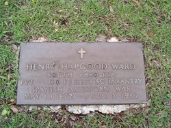
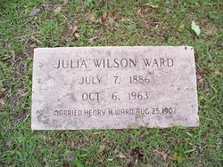
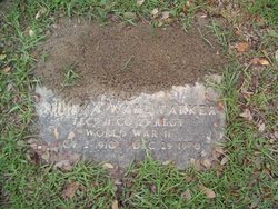
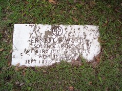
Henry Prentiss Ward
| Birth | : | 2 Apr 1905 Georgetown, Georgetown County, South Carolina, USA |
| Death | : | 6 Jul 1973 Georgetown, Georgetown County, South Carolina, USA |
| Burial | : | Pleasant Hill Cemetery, Berryton, Shawnee County, USA |
| Coordinate | : | 38.9103012, -95.5763016 |
| Inscription | : | Colonel US Army World War II DSC BSM |
| Description | : | DSC Citation The President of the United States of America, authorized by Act of Congress, July 9, 1918, takes pleasure in presenting the Distinguished Service Cross to Lieutenant Colonel Henry P. Ward, United States Army, for extraordinary heroism in connection with military operations against an armed enemy while Commanding a Battalion of Field Artillery, in action against enemy forces in February 1943, in Tunisia. Lieutenant Colonel Ward displayed outstanding generalship during the action of his battalion against a superior enemy force. With utter disregard for his own safety, he exposed himself continuously to the dangers of the enemy fire and... Read More |
frequently asked questions (FAQ):
-
Where is Henry Prentiss Ward's memorial?
Henry Prentiss Ward's memorial is located at: Pleasant Hill Cemetery, Berryton, Shawnee County, USA.
-
When did Henry Prentiss Ward death?
Henry Prentiss Ward death on 6 Jul 1973 in Georgetown, Georgetown County, South Carolina, USA
-
Where are the coordinates of the Henry Prentiss Ward's memorial?
Latitude: 38.9103012
Longitude: -95.5763016
Family Members:
Parent
Spouse
Siblings

Flowers:


Nearby Cemetories:
1. Pleasant Hill Cemetery
Berryton, Shawnee County, USA
Coordinate: 38.9103012, -95.5763016
2. Beam Cemetery
Shawnee County, USA
Coordinate: 38.8847600, -95.6160300
3. Boles Cemetery
Shawnee County, USA
Coordinate: 38.8798400, -95.5307200
4. Richland Cemetery
Richland, Shawnee County, USA
Coordinate: 38.8767014, -95.5196991
5. Emmanuel Cemetery
Watson, Shawnee County, USA
Coordinate: 38.9719009, -95.5744019
6. Riggs Family Cemetery
Clinton, Douglas County, USA
Coordinate: 38.8949300, -95.4978100
7. Yocum Cemetery
Wakarusa, Shawnee County, USA
Coordinate: 38.8849983, -95.6552963
8. Lynn Creek Cemetery
Berryton, Shawnee County, USA
Coordinate: 38.9575005, -95.6408005
9. Ridgeway Cemetery
Osage County, USA
Coordinate: 38.8408012, -95.6066971
10. Bauer Cemetery
Topeka, Shawnee County, USA
Coordinate: 38.9864006, -95.5764008
11. Zion Cemetery
Watson, Shawnee County, USA
Coordinate: 38.9861984, -95.5481033
12. Twin Mound Cemetery
Clinton, Douglas County, USA
Coordinate: 38.8692017, -95.4819031
13. Bethel Cemetery
Topeka, Shawnee County, USA
Coordinate: 39.0085983, -95.5864029
14. Mound View Cemetery
Stull, Douglas County, USA
Coordinate: 38.9425011, -95.4558029
15. Shawnee Center Cemetery
Wakarusa, Shawnee County, USA
Coordinate: 38.8778000, -95.7058029
16. Rock Creek Cemetery
Douglas County, USA
Coordinate: 38.8488998, -95.4561005
17. Stull Cemetery
Stull, Douglas County, USA
Coordinate: 38.9714203, -95.4546204
18. Saint Peters Cemetery
Lecompton, Douglas County, USA
Coordinate: 39.0139885, -95.4941635
19. Clinton Cemetery
Clinton, Douglas County, USA
Coordinate: 38.9136009, -95.4105988
20. Foster Cemetery
Topeka, Shawnee County, USA
Coordinate: 38.9942017, -95.7061005
21. Eastview Cemetery
Big Springs, Douglas County, USA
Coordinate: 39.0222015, -95.4858475
22. Carbondale Cemetery
Carbondale, Osage County, USA
Coordinate: 38.7963982, -95.6663971
23. Simerwell Cemetery
Shawnee County, USA
Coordinate: 38.9132004, -95.7483597
24. Overbrook Cemetery
Overbrook, Osage County, USA
Coordinate: 38.7751083, -95.5487442