
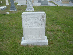
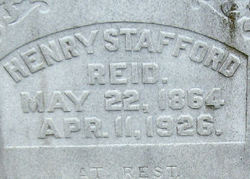

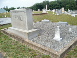
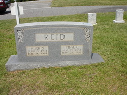
Henry Stafford Reid
| Birth | : | 22 May 1864 Greenville County, South Carolina, USA |
| Death | : | 11 Apr 1926 Gowensville, Greenville County, South Carolina, USA |
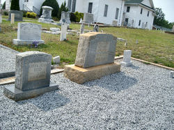
| Burial | : | Hazelgrove Cemetery, Hazelgrove, Oberon Shire, Australia |
| Coordinate | : | -33.6626790, 149.8936880 |
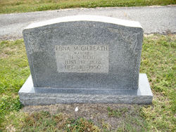
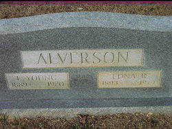
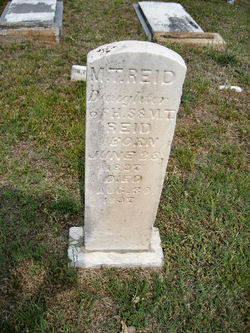
| Description | : | PROSPEROUS FARMER OF GOWANSVILLE DIES GREER, April 12 - (Special) H. S. Reid, 63, prosperous and substantial farmer of Gowansville, died yesterday morning at 9:40 o'clock at his home, after an illness of one years duration of chronic valvular heart disease. The funeral will be held on tomorrow afternoon at 2 o'clock at the Gowansville Baptist Church, conducted by the Pastor of the deceased. Mr. Reid is survived by his widow, who before her first marriage to Dr. Greene Smith, was Miss Edna Gilreath; by the following children; Mrs. Lizzie Gosnell, Mrs. Edna Alverson of Gowansville, Mrs. Ethel Allen of Taylors, Miss Eloise... Read More |
frequently asked questions (FAQ):
-
Where is Henry Stafford Reid's memorial?
Henry Stafford Reid's memorial is located at: Hazelgrove Cemetery, Hazelgrove, Oberon Shire, Australia.
-
When did Henry Stafford Reid death?
Henry Stafford Reid death on 11 Apr 1926 in Gowensville, Greenville County, South Carolina, USA
-
Where are the coordinates of the Henry Stafford Reid's memorial?
Latitude: -33.6626790
Longitude: 149.8936880
Family Members:
Parent

Spouse
Siblings

Children
Flowers:


Nearby Cemetories:
1. Hazelgrove Cemetery
Hazelgrove, Oberon Shire, Australia
Coordinate: -33.6626790, 149.8936880
2. Oberon Old Methodist Cemetery
Oberon, Oberon Shire, Australia
Coordinate: -33.7083240, 149.8775790
3. Oberon Old Anglican Cemetery
Oberon, Oberon Shire, Australia
Coordinate: -33.7044740, 149.8590950
4. Lone Graves
Oberon, Oberon Shire, Australia
Coordinate: -33.7040630, 149.8558330
5. Oberon General Cemetery
Oberon, Oberon Shire, Australia
Coordinate: -33.7061300, 149.8340300
6. Tarana Anglican Cemetery
Tarana, Lithgow City, Australia
Coordinate: -33.5434610, 149.8702260
7. Foleys Creek Cemetery
Essington, Oberon Shire, Australia
Coordinate: -33.7357790, 149.7359920
8. Brisbane Valley Catholic Cemetery
Oberon Shire, Australia
Coordinate: -33.7359520, 149.7358260
9. Lowther Cemetery
Lowther, Lithgow City, Australia
Coordinate: -33.6191500, 150.1034590
10. O'Connell Anglican Cemetery
O'Connell, Bathurst Regional Council, Australia
Coordinate: -33.5365300, 149.7232250
11. O'Connell Catholic Cemetery
O'Connell, Bathurst Regional Council, Australia
Coordinate: -33.5363870, 149.7227100
12. St Mathew's Catholic Cemetery
Rydal, Lithgow City, Australia
Coordinate: -33.4836080, 150.0319580
13. Rydal Cemetery
Rydal, Lithgow City, Australia
Coordinate: -33.4779400, 150.0370020
14. Mount Lambie Presbyterian Cemetery
Mount Lambie, Lithgow City, Australia
Coordinate: -33.4490740, 149.9638810
15. Yetholme Anglican Cemetery
Yetholme, Bathurst Regional Council, Australia
Coordinate: -33.4480020, 149.8184970
16. Black Springs Cemetery
Black Springs, Oberon Shire, Australia
Coordinate: -33.8508220, 149.7403260
17. Meadow Flat General Cemetery
Meadow Flat, Lithgow City, Australia
Coordinate: -33.4279310, 149.9169870
18. Kirkconnell Catholic Cemetery
Yetholme, Bathurst Regional Council, Australia
Coordinate: -33.4294620, 149.8520360
19. Bowenfels Catholic Cemetery
Bowenfels, Lithgow City, Australia
Coordinate: -33.5148600, 150.1207200
20. Macquarie Plains Methodist
Bathurst, Bathurst Regional Council, Australia
Coordinate: -33.4950940, 149.6818940
21. Bowenfels Old Presbyterian Cemetery
Bowenfels, Lithgow City, Australia
Coordinate: -33.5115024, 150.1231527
22. Shooters Hill Cemetery
Oberon, Oberon Shire, Australia
Coordinate: -33.9067340, 149.8546910
23. Forty Bends Private Cemetery
Bowenfels, Lithgow City, Australia
Coordinate: -33.5200000, 150.1430000
24. Moyne Family Cemetery
Hartley, Lithgow City, Australia
Coordinate: -33.5967299, 150.1933980