
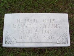
Herbert Maxwell “Chip” Collins
| Birth | : | 8 Mar 1946 Conway, Horry County, South Carolina, USA |
| Death | : | 28 Jul 2007 Winder, Barrow County, Georgia, USA |
| Burial | : | Kingsley Lake Cemetery, Clay County, USA |
| Coordinate | : | 29.9686070, -82.0158140 |
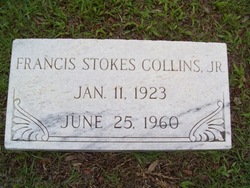
| Description | : | Herbert CollinsHerbert ""Chip"" Collins, 61, of Winder, Ga., died Saturday, July 28, 2007. Funeral services were Tuesday, July 31, 2007, at 11 a.m. at St. Columbus Episcopal Church with a 2 p.m. graveside service at Elmwood Cemetery in Georgetown. Mayer Funeral Home, Georgetown Chapel was in charge of arrangements.Sign an online guestbook at www.mayerfuneralhome.com. Mr. Collins was born in Conway, a son of the late Francis Stokes Collins and Mary Louise Staats Collins Doyle. He was a stepson of Authar H. Doyle of Georgetown.He was a member of St. Columbus Episcopal Church of Johnscreek, the American Society of Testing Materials, a... Read More |
frequently asked questions (FAQ):
-
Where is Herbert Maxwell “Chip” Collins's memorial?
Herbert Maxwell “Chip” Collins's memorial is located at: Kingsley Lake Cemetery, Clay County, USA.
-
When did Herbert Maxwell “Chip” Collins death?
Herbert Maxwell “Chip” Collins death on 28 Jul 2007 in Winder, Barrow County, Georgia, USA
-
Where are the coordinates of the Herbert Maxwell “Chip” Collins's memorial?
Latitude: 29.9686070
Longitude: -82.0158140
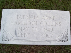
Family Members:
Parent

Spouse
Flowers:


Nearby Cemetories:
1. Kingsley Lake Cemetery
Clay County, USA
Coordinate: 29.9686070, -82.0158140
2. Old Conway Cemetery
Middleburg, Clay County, USA
Coordinate: 29.9827995, -81.9499969
3. John James Conway Cemetery
Kingsley, Clay County, USA
Coordinate: 29.9847083, -81.9499893
4. German POW Camp Cemetery
Clay County, USA
Coordinate: 29.9410900, -81.9472530
5. Oak Grove Cemetery
Clay County, USA
Coordinate: 30.0121994, -81.9555969
6. Griffis Family Cemetery
Starke, Bradford County, USA
Coordinate: 29.9107826, -82.0797910
7. Peetsville Cemetery
Lawtey, Bradford County, USA
Coordinate: 30.0257030, -82.0816250
8. Saint Marks Episcopal Church Cemetery
Starke, Bradford County, USA
Coordinate: 29.9445190, -82.1065280
9. Oak Grove Baptist Church Cemetery
Middleburg, Clay County, USA
Coordinate: 30.0117702, -81.9307556
10. Beulah Cemetery
Kingsley, Clay County, USA
Coordinate: 29.9421997, -81.9186020
11. Pleasant Grove Cemetery
Starke, Bradford County, USA
Coordinate: 29.9751580, -82.1360560
12. Lawtey Cemetery
Lawtey, Bradford County, USA
Coordinate: 30.0526300, -82.0909700
13. Beulah Missionary Baptist Church Cemetery
Green Cove Springs, Clay County, USA
Coordinate: 29.9427376, -81.8963776
14. Lee Cemetery
Clay County, USA
Coordinate: 29.8568993, -82.0175018
15. Blue Pond Cemetery
Clay County, USA
Coordinate: 29.8558006, -82.0327988
16. Crosby Lake Cemetery
Starke, Bradford County, USA
Coordinate: 29.9493999, -82.1472015
17. DeSue Cemetery
Starke, Bradford County, USA
Coordinate: 29.9748840, -82.1499700
18. Fowler Cemetery
Middleburg, Clay County, USA
Coordinate: 30.0286007, -81.9005966
19. Bob Lov Cemetery
Starke, Bradford County, USA
Coordinate: 29.9754200, -82.1500092
20. Odd Fellows Cemetery
Starke, Bradford County, USA
Coordinate: 29.9006700, -82.1273090
21. Brymer Cemetery
Starke, Bradford County, USA
Coordinate: 29.9006700, -82.1273100
22. Prevatt Cemetery
Bradford County, USA
Coordinate: 29.9041996, -82.1378021
23. Evergreen Cemetery
Belmore, Clay County, USA
Coordinate: 29.8994045, -81.8950958
24. Hope Baptist Cemetery
Starke, Bradford County, USA
Coordinate: 29.8381004, -82.0682983