
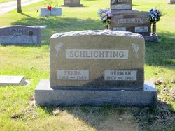
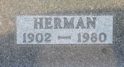
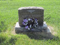
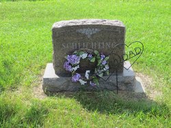
Herman A Schlichting
| Birth | : | 1 Apr 1902 Otter Tail County, Minnesota, USA |
| Death | : | 14 Sep 1980 Garrison, McLean County, North Dakota, USA |
| Burial | : | Garrison Cemetery, Garrison, McLean County, USA |
| Coordinate | : | 47.6650000, -101.4201000 |
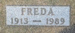
| Description | : | Herman A SCHLICHTING born 1 April 1902 in Otter Tail County, Minnesota was the son of Otto Henry SCHLICHTING and Anna STUTTZ. Herman married Freda A SAYLER on the 31 March 1934 in McLean County, North Dakota. Bio by DG Bender ============================= |
frequently asked questions (FAQ):
-
Where is Herman A Schlichting's memorial?
Herman A Schlichting's memorial is located at: Garrison Cemetery, Garrison, McLean County, USA.
-
When did Herman A Schlichting death?
Herman A Schlichting death on 14 Sep 1980 in Garrison, McLean County, North Dakota, USA
-
Where are the coordinates of the Herman A Schlichting's memorial?
Latitude: 47.6650000
Longitude: -101.4201000
Family Members:
Parent
Spouse
Siblings
Flowers:


Nearby Cemetories:
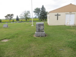
1. Garrison Cemetery
Garrison, McLean County, USA
Coordinate: 47.6650000, -101.4201000
2. Saint Nicholas Cemetery
Garrison, McLean County, USA
Coordinate: 47.6469210, -101.3976590
3. Kloestitz German Cemetery
McLean County, USA
Coordinate: 47.6739490, -101.3461250
4. Saint Pauls Cemetery
Garrison, McLean County, USA
Coordinate: 47.6570200, -101.3344940
5. Fort Stevenson Post Cemetery
McLean County, USA
Coordinate: 47.5758800, -101.4453500
6. Saint Pauls Lutheran Cemetery
Douglas Township, McLean County, USA
Coordinate: 47.7476349, -101.4856491
7. Endres Catholic Cemetery
Max, McLean County, USA
Coordinate: 47.7099075, -101.2397003
8. Zion Lutheran Cemetery
Max, McLean County, USA
Coordinate: 47.7653999, -101.2937622
9. Clifton Cemetery
McLean County, USA
Coordinate: 47.7317009, -101.6235962
10. Saint Peter Cemetery
Emmet, McLean County, USA
Coordinate: 47.6742020, -101.6510010
11. Geminde Cemetery
Mercer County, USA
Coordinate: 47.5172005, -101.5061035
12. Saint Johns Congregational Cemetery
Max, McLean County, USA
Coordinate: 47.6871730, -101.1750700
13. Max City Cemetery
Max, McLean County, USA
Coordinate: 47.8127100, -101.2935300
14. Miller Cemetery
Pick City, Mercer County, USA
Coordinate: 47.5018480, -101.5100250
15. Max City Cemetery Old
Max, McLean County, USA
Coordinate: 47.8268088, -101.3014727
16. Evangelical Lutheran Cemetery
Max, McLean County, USA
Coordinate: 47.8268000, -101.3000000
17. Saint Mathew Cemetery
Max, McLean County, USA
Coordinate: 47.7755740, -101.1972780
18. Trinity Mannhaven Cemetery
Pick City, Mercer County, USA
Coordinate: 47.4880260, -101.5064950
19. Immaculate Conception Cemetery
Max, McLean County, USA
Coordinate: 47.8177986, -101.2613983
20. Lilly Dale Cemetery
Emmet, McLean County, USA
Coordinate: 47.5887050, -101.6742500
21. First German Baptist Cemetery
Max, McLean County, USA
Coordinate: 47.6887283, -101.1341629
22. First Baptist Cemetery
Ward County, USA
Coordinate: 47.8484612, -101.2989349
23. Douglas City Cemetery
Douglas, Ward County, USA
Coordinate: 47.8610600, -101.4975100
24. Coleharbor Cemetery
Coleharbor, McLean County, USA
Coordinate: 47.5024986, -101.2369003