
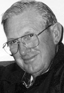
Herman Allen “Herb” Paulsen
| Birth | : | 7 Jul 1929 Benton County, Iowa, USA |
| Death | : | 23 Nov 2013 Coralville, Johnson County, Iowa, USA |
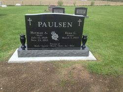
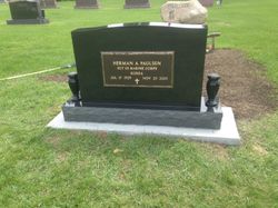
| Burial | : | Holy Cross Cemetery, Keystone, Benton County, USA |
| Coordinate | : | 41.9961014, -92.1825027 |
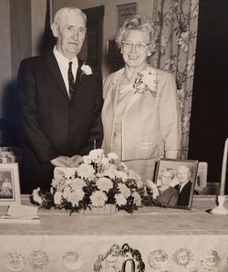
| Description | : | Herman (Herb) Allen Paulsen of Coralville, and formerly of Keystone, passed away at Lantern Park Nursing and Rehab Center Nov. 23, 2013. Herman was born on the family farm outside of Keystone, Iowa, July 17, 1929, the son of Herman and Ella (Tecklenburg) Paulsen. He attended country school and graduated from Keystone High School in 1947. On Nov. 14, 1950, he married Ilene Pickart at St. Mary's Catholic Church in Vinton. He served in the Marine Corps from January 1951 until December 1952. He returned to the family farm where he and Ilene began raising their family. He took an active role... Read More |
frequently asked questions (FAQ):
-
Where is Herman Allen “Herb” Paulsen's memorial?
Herman Allen “Herb” Paulsen's memorial is located at: Holy Cross Cemetery, Keystone, Benton County, USA.
-
When did Herman Allen “Herb” Paulsen death?
Herman Allen “Herb” Paulsen death on 23 Nov 2013 in Coralville, Johnson County, Iowa, USA
-
Where are the coordinates of the Herman Allen “Herb” Paulsen's memorial?
Latitude: 41.9961014
Longitude: -92.1825027
Family Members:
Parent
Siblings

Flowers:


Nearby Cemetories:
1. Holy Cross Cemetery
Keystone, Benton County, USA
Coordinate: 41.9961014, -92.1825027
2. Keystone Cemetery
Keystone, Benton County, USA
Coordinate: 41.9939003, -92.2172012
3. Van Metre Cemetery
Keystone, Benton County, USA
Coordinate: 41.9614983, -92.1514969
4. Bender Cemetery
Keystone, Benton County, USA
Coordinate: 42.0363998, -92.1536026
5. Calvary Cemetery
Van Horne, Benton County, USA
Coordinate: 41.9641991, -92.1138992
6. LaRue Cemetery
Benton County, USA
Coordinate: 42.0574989, -92.1438980
7. Ranstead Cemetery
Luzerne, Benton County, USA
Coordinate: 41.9201622, -92.1613846
8. Kirchner Cemetery
Benton County, USA
Coordinate: 42.0727300, -92.2027400
9. Redman Cemetery
Benton County, USA
Coordinate: 41.9710999, -92.2917023
10. Irving Cemetery
Irving, Benton County, USA
Coordinate: 41.9505997, -92.2797012
11. Twogood Cemetery
Benton County, USA
Coordinate: 42.0499992, -92.2799988
12. Big Grove-Homer Cemetery
Benton County, USA
Coordinate: 42.0867004, -92.1821976
13. Lutheran Cemetery
Luzerne, Benton County, USA
Coordinate: 41.8991950, -92.1852390
14. International Cemetery
Luzerne, Benton County, USA
Coordinate: 41.8981018, -92.1800003
15. Wright Cemetery
Belle Plaine, Benton County, USA
Coordinate: 41.9136009, -92.2643967
16. Arbuthnot Cemetery
Chelsea, Tama County, USA
Coordinate: 41.9416550, -92.3001787
17. Salem Cemetery
Van Horne, Benton County, USA
Coordinate: 41.9928017, -92.0421982
18. Oak Hill Cemetery
Belle Plaine, Benton County, USA
Coordinate: 41.8987007, -92.2571030
19. Indian Cemetery
Garrison, Benton County, USA
Coordinate: 42.0999956, -92.1168495
20. Beal Pioneer Cemetery
Belle Plaine, Benton County, USA
Coordinate: 41.8903008, -92.2538986
21. Waltham Cemetery
Elberon, Tama County, USA
Coordinate: 42.0355988, -92.3328018
22. Prairie Cemetery
Van Horne, Benton County, USA
Coordinate: 41.9626440, -92.0282390
23. Dvorak Cemetery
Elberon, Tama County, USA
Coordinate: 41.9713000, -92.3417000
24. Lone Pine Cemetery
Tama County, USA
Coordinate: 42.0797005, -92.3082962