
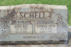

Herman Jacob Schell
| Birth | : | 23 Apr 1906 Missouri, USA |
| Death | : | 3 Jun 1967 Stanislaus County, California, USA |
| Burial | : | Stevinson Sunnyside Cemetery, Stevinson, Merced County, USA |
| Coordinate | : | 37.3292007, -120.9231033 |
| Description | : | Delhi Express Thursday, June 8, 1967, Front Page Grange Master Herman Schell Dies At 61 Caring For Grange Grounds Perhaps it was only right that Herman Schell, grange master of the Delhi Grange, should have died with a shovel in his hand, working on the Grange grounds that he loved so well. Schell was 61 and friends said he had never suffered a heart attack before, but Friday, he was struck suddenly and never regained consciousness. The shovel was there at his side when they found him on the grange property. He was master of the grange and had only recently... Read More |
frequently asked questions (FAQ):
-
Where is Herman Jacob Schell's memorial?
Herman Jacob Schell's memorial is located at: Stevinson Sunnyside Cemetery, Stevinson, Merced County, USA.
-
When did Herman Jacob Schell death?
Herman Jacob Schell death on 3 Jun 1967 in Stanislaus County, California, USA
-
Where are the coordinates of the Herman Jacob Schell's memorial?
Latitude: 37.3292007
Longitude: -120.9231033
Family Members:
Parent
Spouse

Siblings
Children
Flowers:


Nearby Cemetories:
1. Stevinson Sunnyside Cemetery
Stevinson, Merced County, USA
Coordinate: 37.3292007, -120.9231033
2. Colonel James J Stevinson Cemetery
Stevinson, Merced County, USA
Coordinate: 37.3572044, -120.9112320
3. South Hilmar Cemetery
Hilmar, Merced County, USA
Coordinate: 37.3802681, -120.8868408
4. North Hilmar Cemetery
Hilmar, Merced County, USA
Coordinate: 37.4146614, -120.8864288
5. Hills Ferry Cemetery
Newman, Stanislaus County, USA
Coordinate: 37.3321991, -121.0496979
6. Cottonwood Cemetery
Gustine, Merced County, USA
Coordinate: 37.1878128, -121.0403900
7. Turlock Memorial Park
Turlock, Stanislaus County, USA
Coordinate: 37.4937592, -120.8659821
8. Saint Francis Episcopal Church Columbarium
Turlock, Stanislaus County, USA
Coordinate: 37.5014300, -120.8368400
9. Denair Cemetery
Denair, Stanislaus County, USA
Coordinate: 37.5293999, -120.8199997
10. San Joaquin Valley National Cemetery
Santa Nella, Merced County, USA
Coordinate: 37.1198170, -121.0738000
11. Winton Cemetery
Winton, Merced County, USA
Coordinate: 37.3820267, -120.6260223
12. Ceres Memorial Park
Ceres, Stanislaus County, USA
Coordinate: 37.5958214, -120.9634399
13. Patterson District Cemetery
Patterson, Stanislaus County, USA
Coordinate: 37.5268135, -121.1728287
14. Calvary Cemetery
Los Banos, Merced County, USA
Coordinate: 37.0486800, -120.8547000
15. Los Banos Cemetery
Los Banos, Merced County, USA
Coordinate: 37.0470200, -120.8547000
16. Barfield Family Cemetery
Hopeton, Merced County, USA
Coordinate: 37.4675792, -120.6040085
17. Lakewood Memorial Park
Hughson, Stanislaus County, USA
Coordinate: 37.6199760, -120.8975983
18. Franklin Pet Cemetery
Merced, Merced County, USA
Coordinate: 37.3228970, -120.5425370
19. Grayson Cemetery
Grayson, Stanislaus County, USA
Coordinate: 37.5594559, -121.1802826
20. Saint Stanislaus Catholic Cemetery
Modesto, Stanislaus County, USA
Coordinate: 37.6473610, -120.9808440
21. Modesto Pioneer Cemetery
Modesto, Stanislaus County, USA
Coordinate: 37.6473350, -120.9829040
22. Modesto Citizens Cemetery
Modesto, Stanislaus County, USA
Coordinate: 37.6472930, -120.9845570
23. Acacia Memorial Park
Modesto, Stanislaus County, USA
Coordinate: 37.6481080, -120.9836610
24. Modesto County Cemetery
Modesto, Stanislaus County, USA
Coordinate: 37.6492400, -120.9813800