
| Birth | : | 6 Nov 1754 New Haven, New Haven County, Connecticut, USA |
| Death | : | 20 Apr 1815 |
| Burial | : | Saint Mary Magdalene Cemetery, Omaha, Douglas County, USA |
| Coordinate | : | 41.2039420, -95.9850610 |
| Plot | : | 15-0 |
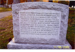
| Inscription | : | AE- 60 |
| Description | : | The "Record of Service of Connecticut Men in the Revolutionary War", p. 7 states that Hezekiah Dickerman served for three days in the Lexington Alarm for New Haven. He and his wife, Hannah (Royce Dickerman) had a very large family; their children are listed in Hannah's memorial. He was a resident of Hamden and was chosen a selectman in 1796 and 1797. In 1803, it was voted that the selectmen of the town of Hamden should clear and keep cleared the old road of the fence ereced by the cheshire Turnpike Company near Hezekiah Dickerman's, since the fence is not ... Read More |
frequently asked questions (FAQ):
-
Where is Hezekiah Dickerman's memorial?
Hezekiah Dickerman's memorial is located at: Saint Mary Magdalene Cemetery, Omaha, Douglas County, USA.
-
When did Hezekiah Dickerman death?
Hezekiah Dickerman death on 20 Apr 1815 in
-
Where are the coordinates of the Hezekiah Dickerman's memorial?
Latitude: 41.2039420
Longitude: -95.9850610
Family Members:
Parent

Spouse
Siblings
Children
Flowers:


Nearby Cemetories:
1. Saint Mary Magdalene Cemetery
Omaha, Douglas County, USA
Coordinate: 41.2039420, -95.9850610
2. Graceland Park Cemetery
Omaha, Douglas County, USA
Coordinate: 41.2113991, -95.9785995
3. Saint Mary's Cemetery
Omaha, Douglas County, USA
Coordinate: 41.2042007, -95.9646988
4. Saint Johns Cemetery
Bellevue, Sarpy County, USA
Coordinate: 41.1864014, -95.9682999
5. Fisher Farm Cemetery
Bellevue, Sarpy County, USA
Coordinate: 41.1727982, -95.9760971
6. Hrabik Cemetery
Bellevue, Sarpy County, USA
Coordinate: 41.1726540, -95.9768200
7. Westlawn-Hillcrest Memorial Park
Omaha, Douglas County, USA
Coordinate: 41.2346992, -95.9966965
8. Laurel Hill Cemetery
Omaha, Douglas County, USA
Coordinate: 41.1918983, -95.9417038
9. Bohemian Cemetery
Omaha, Douglas County, USA
Coordinate: 41.2388992, -95.9955978
10. Douglas County Poor Farm Cemetery
Omaha, Douglas County, USA
Coordinate: 41.2437240, -95.9723480
11. Beth El Cemetery
Ralston, Douglas County, USA
Coordinate: 41.2117004, -96.0428009
12. Ak-Sar-Ben Racetrack Grounds
Omaha, Douglas County, USA
Coordinate: 41.2414703, -96.0159607
13. Calvary Cemetery
Omaha, Douglas County, USA
Coordinate: 41.2364006, -96.0294037
14. Resurrection Cemetery
Omaha, Douglas County, USA
Coordinate: 41.2344208, -96.0365448
15. Holy Sepulchre Cemetery
Omaha, Douglas County, USA
Coordinate: 41.2543983, -95.9875031
16. Papillion Cemetery
Papillion, Sarpy County, USA
Coordinate: 41.1758003, -96.0410995
17. Evergreen Memorial Park Cemetery
Omaha, Douglas County, USA
Coordinate: 41.2393990, -96.0355988
18. First Central Congregational Columbarium
Omaha, Douglas County, USA
Coordinate: 41.2563456, -95.9658365
19. Saint Andrews Episcopal Church Columbarium
Omaha, Douglas County, USA
Coordinate: 41.2492500, -96.0427500
20. Nash Chapel Crypt
Omaha, Douglas County, USA
Coordinate: 41.2665090, -95.9721790
21. Immanuel Lutheran Church Columbarium
Bellevue, Sarpy County, USA
Coordinate: 41.1602700, -95.9218900
22. Countryside Community Church Columbarium
Omaha, Douglas County, USA
Coordinate: 41.2483660, -96.0500270
23. Trinity Cathedral Columbarium
Omaha, Douglas County, USA
Coordinate: 41.2603900, -95.9393660
24. Cedar Dale Cemetery
Papillion, Sarpy County, USA
Coordinate: 41.1418304, -96.0338745