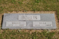
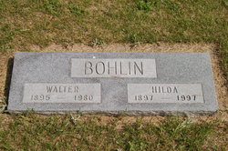
Hilda Elvina Arntz Bohlin
| Birth | : | 20 Oct 1897 Wisconsin, USA |
| Death | : | 20 Nov 1997 Bismarck, Burleigh County, North Dakota, USA |
| Burial | : | Black Oak Ridge Cemetery, Bluford, Jefferson County, USA |
| Coordinate | : | 38.3171997, -88.7711029 |
| Description | : | Hilda A. Bohlin, 100, Missouri Slope Lutheran Care Center, died Nov. 20, 1997, in a Bismarck nursing home. Services will be 11 a.m. Saturday, at St. Katherine's Catholic Church, Braddock. Burial will be in the church cemetery. Visitation will begin at 1 p.m. today at Boelter Funeral Home, Bismarck, where a rosary will be said at 7 this evening. She was born Oct. 20, 1897, in Kilbourne, Wis., the daughter of Theodore and Anna (Legge) Arntz. She traveled with her parents by wagon to Burnstad, N.D., where they homesteaded in 1900. She obtained a teacher's certificate and taught... Read More |
frequently asked questions (FAQ):
-
Where is Hilda Elvina Arntz Bohlin's memorial?
Hilda Elvina Arntz Bohlin's memorial is located at: Black Oak Ridge Cemetery, Bluford, Jefferson County, USA.
-
When did Hilda Elvina Arntz Bohlin death?
Hilda Elvina Arntz Bohlin death on 20 Nov 1997 in Bismarck, Burleigh County, North Dakota, USA
-
Where are the coordinates of the Hilda Elvina Arntz Bohlin's memorial?
Latitude: 38.3171997
Longitude: -88.7711029
Family Members:
Parent
Spouse
Siblings
Children
Flowers:
Nearby Cemetories:
1. Black Oak Ridge Cemetery
Bluford, Jefferson County, USA
Coordinate: 38.3171997, -88.7711029
2. East Hickory Hill Cemetery
Bluford, Jefferson County, USA
Coordinate: 38.3431700, -88.7606900
3. Newton Cemetery
Camp Ground, Jefferson County, USA
Coordinate: 38.3391991, -88.7996979
4. Shelton Cemetery
Opdyke, Jefferson County, USA
Coordinate: 38.2839012, -88.7581024
5. Old Orchard Cemetery
Jefferson County, USA
Coordinate: 38.2980995, -88.8150024
6. Ethridge Cemetery
Marlow, Jefferson County, USA
Coordinate: 38.3133011, -88.8217010
7. Williams Cemetery
Mount Vernon, Jefferson County, USA
Coordinate: 38.3205986, -88.8253021
8. Mount Olive Cemetery
Bluford, Jefferson County, USA
Coordinate: 38.3017600, -88.7077800
9. Atkinson Cemetery
Camp Ground, Jefferson County, USA
Coordinate: 38.3574982, -88.8202972
10. Opdyke Cemetery
Opdyke, Jefferson County, USA
Coordinate: 38.2578011, -88.7746964
11. Clark Cemetery
Camp Ground, Jefferson County, USA
Coordinate: 38.3760986, -88.7960968
12. Medders Cemetery
Jefferson County, USA
Coordinate: 38.2938995, -88.8460999
13. Jefferson County Farm Cemetery
Mount Vernon, Jefferson County, USA
Coordinate: 38.3312750, -88.8506450
14. Oakdale Cemetery
Bluford, Jefferson County, USA
Coordinate: 38.3801400, -88.7426600
15. Mateer-Davis Cemetery
Keenes, Wayne County, USA
Coordinate: 38.3101400, -88.6802700
16. Laird Cemetery
Belle Rive, Jefferson County, USA
Coordinate: 38.2631000, -88.7113000
17. Buffington-French Cemetery
Harmony, Jefferson County, USA
Coordinate: 38.3871500, -88.7426230
18. Egbert Cemetery
Keenes, Wayne County, USA
Coordinate: 38.3428001, -88.6808014
19. Belle Rive Cemetery
Belle Rive, Jefferson County, USA
Coordinate: 38.2456017, -88.7407990
20. Smith Farm Cemetery
Opdyke, Jefferson County, USA
Coordinate: 38.2431500, -88.8034600
21. East Salem Cemetery
Jefferson County, USA
Coordinate: 38.3706044, -88.8467283
22. Warren Cemetery
Jefferson County, USA
Coordinate: 38.2475014, -88.8274994
23. Long Prairie Cemetery
Middleton, Wayne County, USA
Coordinate: 38.2782600, -88.6771080
24. Arnold Cemetery
Mount Vernon, Jefferson County, USA
Coordinate: 38.2531013, -88.8432999


