
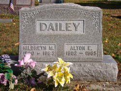
Hildreth May Smith Dailey
| Birth | : | 31 May 1900 Whitley County, Indiana, USA |
| Death | : | 31 Dec 1983 |
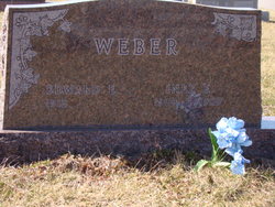
| Burial | : | Grant-Mjessepe Cemetery, Horton, Brown County, USA |
| Coordinate | : | 39.6663000, -95.6576000 |
| Plot | : | Annex B-48-3 |
| Inscription | : | w/o Alton |
| Description | : | Hildreth May Smith married Alton E. Dailey on 21 December 1921 in Whitley County, Indiana (Book 9:254). |
frequently asked questions (FAQ):
-
Where is Hildreth May Smith Dailey's memorial?
Hildreth May Smith Dailey's memorial is located at: Grant-Mjessepe Cemetery, Horton, Brown County, USA.
-
When did Hildreth May Smith Dailey death?
Hildreth May Smith Dailey death on 31 Dec 1983 in
-
Where are the coordinates of the Hildreth May Smith Dailey's memorial?
Latitude: 39.6663000
Longitude: -95.6576000
Family Members:
Parent

Spouse

Siblings
Children
Flowers:


Nearby Cemetories:
1. Grant-Mjessepe Cemetery
Horton, Brown County, USA
Coordinate: 39.6663000, -95.6576000
2. Jessepe Indian Cemetery
Horton, Brown County, USA
Coordinate: 39.6715000, -95.6438000
3. Kennekuk Church Cemetery
Horton, Brown County, USA
Coordinate: 39.7074600, -95.6672300
4. Saint Peters Cemetery
Mercier, Brown County, USA
Coordinate: 39.7247009, -95.6016998
5. Spring Hill Cemetery
Whiting, Jackson County, USA
Coordinate: 39.6021996, -95.6121979
6. Lutheran Cemetery
Mercier, Brown County, USA
Coordinate: 39.7250500, -95.6000710
7. Wheatland Cemetery
Atchison County, USA
Coordinate: 39.6453018, -95.5633011
8. Netawaka Cemetery
Netawaka, Jackson County, USA
Coordinate: 39.6075300, -95.7223700
9. South Powhattan Cemetery
Powhattan, Brown County, USA
Coordinate: 39.6608009, -95.7596970
10. Grasshopper Burial Ground
Powhattan Township, Brown County, USA
Coordinate: 39.7578020, -95.6949820
11. Powhattan Cemetery
Powhattan, Brown County, USA
Coordinate: 39.7681007, -95.6288986
12. Comet Cemetery
Powhattan Township, Brown County, USA
Coordinate: 39.7542600, -95.7340400
13. Horton Cemetery
Horton, Brown County, USA
Coordinate: 39.6573982, -95.5126419
14. Wetmore Cemetery
Wetmore, Nemaha County, USA
Coordinate: 39.6396800, -95.8108400
15. Granada Cemetery
Granada, Nemaha County, USA
Coordinate: 39.7324982, -95.7988968
16. Saint Leos Catholic Cemetery
Horton, Brown County, USA
Coordinate: 39.6667595, -95.4889603
17. Kennekuk Cemetery
Horton, Brown County, USA
Coordinate: 39.6533012, -95.4875031
18. Estes Cemetery
Jackson County, USA
Coordinate: 39.5346985, -95.6168976
19. Pleasant Grove Cemetery
Jackson County, USA
Coordinate: 39.5664000, -95.7789000
20. Brush Creek Cemetery
Kennekuk, Atchison County, USA
Coordinate: 39.6096992, -95.4702988
21. Muscotah Cemetery
Muscotah, Atchison County, USA
Coordinate: 39.5539017, -95.5121994
22. Wolfley Cemetery
Goff, Nemaha County, USA
Coordinate: 39.6454400, -95.8633900
23. Saint Augustine Catholic Cemetery
Capioma Township, Nemaha County, USA
Coordinate: 39.7904282, -95.7897034
24. Claytonville Cemetery
Horton, Brown County, USA
Coordinate: 39.7766991, -95.5046997