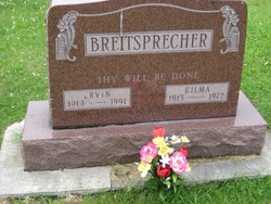
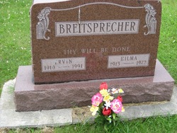
Hilma Ella Seeland Breitsprecher
| Birth | : | 22 Nov 1913 Clayton County, Iowa, USA |
| Death | : | 5 Jun 1972 Elkader, Clayton County, Iowa, USA |
| Burial | : | Warragul Cemetery, Warragul, Baw Baw Shire, Australia |
| Coordinate | : | -38.1528830, 145.9333490 |
| Description | : | The Clayton County Register, Wednesday June 14, 1972 pg. 8A Mrs. Ervin (Hilma) Breitsprecher Funeral services were held at Zion Lutheran Church, Clayton Center, Thursday, June 8, at 1:30 for Mrs. Ervin (Hilma) Breitsprecher who died of coronary thrombosis at Central Community Hospital, Elkader, on June 5, 1972. Mrs. Breitsprecher had been ill for four weeks. Hilma Ella Seeland, was born November 22, 1913, in Boardman Township, Clayton County to Henry and Caroline Glawe Seeland. her education was in the rural schools of the county. She was married to Ervin Breitsprecher in Read Township and lived on a farm near Clayton Center until... Read More |
frequently asked questions (FAQ):
-
Where is Hilma Ella Seeland Breitsprecher's memorial?
Hilma Ella Seeland Breitsprecher's memorial is located at: Warragul Cemetery, Warragul, Baw Baw Shire, Australia.
-
When did Hilma Ella Seeland Breitsprecher death?
Hilma Ella Seeland Breitsprecher death on 5 Jun 1972 in Elkader, Clayton County, Iowa, USA
-
Where are the coordinates of the Hilma Ella Seeland Breitsprecher's memorial?
Latitude: -38.1528830
Longitude: 145.9333490
Family Members:
Spouse
Flowers:
Nearby Cemetories:
1. Warragul Cemetery
Warragul, Baw Baw Shire, Australia
Coordinate: -38.1528830, 145.9333490
2. Gulwarra Heights Cemetery
Warragul, Baw Baw Shire, Australia
Coordinate: -38.1517400, 145.8971990
3. Drouin Cemetery
Drouin, Baw Baw Shire, Australia
Coordinate: -38.1230656, 145.8318535
4. Drouin West Cemetery
Drouin West, Baw Baw Shire, Australia
Coordinate: -38.0923773, 145.8431423
5. Yarragon Cemetery
Yarragon, Baw Baw Shire, Australia
Coordinate: -38.2013220, 146.0547570
6. Ripplebrook Cemetery
Drouin South, Baw Baw Shire, Australia
Coordinate: -38.2074990, 145.7508310
7. Saint Mary's Anglican Church
Trafalgar, Baw Baw Shire, Australia
Coordinate: -38.2112176, 146.1548115
8. Bunyip Cemetery
Bunyip, Cardinia Shire, Australia
Coordinate: -38.0838160, 145.7169040
9. Neerim Cemetery
Neerim, Baw Baw Shire, Australia
Coordinate: -37.9573912, 145.9553572
10. Willow Grove Cemetery
Willow Grove, Baw Baw Shire, Australia
Coordinate: -38.0694800, 146.1750300
11. Trafalgar Cemetery
Trafalgar, Baw Baw Shire, Australia
Coordinate: -38.1998610, 146.1964090
12. Childers and Thorpdale Cemetery
Thorpdale, Baw Baw Shire, Australia
Coordinate: -38.3060020, 146.1422990
13. Poowong Cemetery
Poowong, South Gippsland Shire, Australia
Coordinate: -38.3461002, 145.7615830
14. Allambee East Cemetery
Allambee South, South Gippsland Shire, Australia
Coordinate: -38.3594710, 146.0860860
15. Moe Cemetery
Moe, Latrobe City, Australia
Coordinate: -38.1857360, 146.2685000
16. Narracan
Narracan East, Baw Baw Shire, Australia
Coordinate: -38.2797411, 146.2459113
17. Nyora Cemetery
Nyora, South Gippsland Shire, Australia
Coordinate: -38.3406970, 145.6637270
18. Korumburra Cemetery
Korumburra, South Gippsland Shire, Australia
Coordinate: -38.4303000, 145.8482100
19. Maryknoll Cemetery
Maryknoll, Cardinia Shire, Australia
Coordinate: -38.0279016, 145.6027254
20. Yallourn Cemetery
Yallourn, Latrobe City, Australia
Coordinate: -38.2003610, 146.3114980
21. Coal Creek Community Park and Museum
Korumburra, South Gippsland Shire, Australia
Coordinate: -38.4438019, 145.8312988
22. Lang Lang Cemetery
Lang Lang, Cardinia Shire, Australia
Coordinate: -38.2779980, 145.5831970
23. Mirboo North Cemetery
South Gippsland Shire, Australia
Coordinate: -38.4030220, 146.1725580
24. Leongatha Cemetery
Leongatha, South Gippsland Shire, Australia
Coordinate: -38.4831187, 145.9380932


