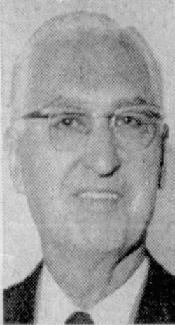
Howard Thomas Ball
| Birth | : | 20 Aug 1900 Globe, Gila County, Arizona, USA |
| Death | : | 6 Sep 1978 Spokane, Spokane County, Washington, USA |
| Burial | : | Spokane Memorial Gardens, Spokane, Spokane County, USA |
| Coordinate | : | 47.5988998, -117.4393997 |
| Description | : | The Spokesman-Review - Sep 8, 1978 Civic Leader Howard Ball Dies Civic leader and funeral director, Howard T. Ball, 78, who served in elective offices on the city, county and state levels, died Wednesday in a Spokane hospital. Mr. Ball had been a part of government in Washington state for 24 years. He started public service with the Legislature in 1947, serving five terms. He rose to become chairman of the Roads and Bridges Committee. Born in Globe, Arizona, he moved to Spokane in 1930. A republican, he ran unsuccessfully for lieutenant governor in 1956. The following year he was named to Spokane's Planning... Read More |
frequently asked questions (FAQ):
-
Where is Howard Thomas Ball's memorial?
Howard Thomas Ball's memorial is located at: Spokane Memorial Gardens, Spokane, Spokane County, USA.
-
When did Howard Thomas Ball death?
Howard Thomas Ball death on 6 Sep 1978 in Spokane, Spokane County, Washington, USA
-
Where are the coordinates of the Howard Thomas Ball's memorial?
Latitude: 47.5988998
Longitude: -117.4393997
Family Members:
Parent
Spouse
Siblings
Children
Flowers:
Nearby Cemetories:
1. Spokane Memorial Gardens
Spokane, Spokane County, USA
Coordinate: 47.5988998, -117.4393997
2. Saint Stephens Episcopal Church Columbarium
Spokane, Spokane County, USA
Coordinate: 47.6017230, -117.3911700
3. Moran Cemetery
Spokane, Spokane County, USA
Coordinate: 47.5957985, -117.3685989
4. Saint John The Evangelist Columbarium
Spokane, Spokane County, USA
Coordinate: 47.6450000, -117.4105000
5. Greenwood Memorial Terrace
Spokane, Spokane County, USA
Coordinate: 47.6568985, -117.4708023
6. Riverside Memorial Park
Spokane, Spokane County, USA
Coordinate: 47.6599998, -117.4606018
7. Mount Nebo Cemetery
Spokane, Spokane County, USA
Coordinate: 47.6624985, -117.4689026
8. Marshall Cemetery
Spokane, Spokane County, USA
Coordinate: 47.5724983, -117.5302963
9. Queen of Peace Cemetery
Spokane, Spokane County, USA
Coordinate: 47.5893200, -117.3409370
10. Fort George Wright Cemetery
Spokane, Spokane County, USA
Coordinate: 47.6821290, -117.4802020
11. Woodlawn Cemetery
Spokane, Spokane County, USA
Coordinate: 47.6492004, -117.3135986
12. Fairmount Memorial Park
Spokane, Spokane County, USA
Coordinate: 47.7075005, -117.4869003
13. Green Mound Cemetery
Cheney, Spokane County, USA
Coordinate: 47.5155983, -117.5736008
14. Saint Davids Episcopal Church Columbarium
Spokane, Spokane County, USA
Coordinate: 47.7244630, -117.4224170
15. Holy Cross Cemetery
Spokane, Spokane County, USA
Coordinate: 47.7242012, -117.4160995
16. Chester Community Cemetery
Chester, Spokane County, USA
Coordinate: 47.6138802, -117.2486343
17. Saint John Vianney Catholic Church Columbarium
Spokane, Spokane County, USA
Coordinate: 47.6619000, -117.2715000
18. Pines Cemetery
Spokane Valley, Spokane County, USA
Coordinate: 47.6425018, -117.2416992
19. Spring Valley Cemetery
Spring Valley, Spokane County, USA
Coordinate: 47.5150140, -117.2713870
20. South Pines Cemetery
Spokane, Spokane County, USA
Coordinate: 47.6277000, -117.2261500
21. Wood Memorial Cemetery
Valleyford, Spokane County, USA
Coordinate: 47.5071983, -117.2692032
22. Holy Rosary Cemetery
Spokane, Spokane County, USA
Coordinate: 47.7360039, -117.3408051
23. Saint Michael Mission Cemetery
Spokane County, USA
Coordinate: 47.7308300, -117.3258400
24. Jesuit Cemetery of the Oregon Province
Spokane, Spokane County, USA
Coordinate: 47.7364006, -117.3394012


