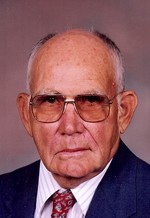
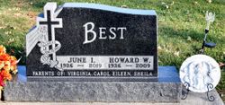
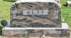
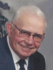
Howard William Best
| Birth | : | 26 Aug 1926 Aplington, Butler County, Iowa, USA |
| Death | : | 16 Jun 2009 Grundy Center, Grundy County, Iowa, USA |
| Burial | : | Swanwater West General Cemetery, Swanwater West, Northern Grampians Shire, Australia |
| Coordinate | : | -36.5154190, 143.0243750 |
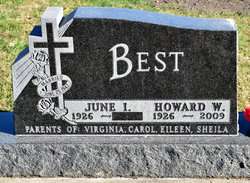
| Inscription | : | Married June 25, 1947 Parents Of: Virginia, Carol, Eileen, Sheila |
| Description | : | Howard William Best, age 82, of Aplington, Iowa, was born August 26, 1926, the son of William J. and Lena Voss Best near Aplington in Butler County, Iowa. He graduated from Aplington High School in 1944. Howard was united in marriage with June Groeneveld on June 25, 1947, in the home of her parents south of Aplington, Iowa. The couple made their home on her parents' farm south of Aplington until 1974. They later moved to a farm east of that place where they built a new home. They farmed and raised cattle for 45 years. Howard retired from farming... Read More |
frequently asked questions (FAQ):
-
Where is Howard William Best's memorial?
Howard William Best's memorial is located at: Swanwater West General Cemetery, Swanwater West, Northern Grampians Shire, Australia.
-
When did Howard William Best death?
Howard William Best death on 16 Jun 2009 in Grundy Center, Grundy County, Iowa, USA
-
Where are the coordinates of the Howard William Best's memorial?
Latitude: -36.5154190
Longitude: 143.0243750
Family Members:
Parent
Spouse
Siblings
Nearby Cemetories:
1. Swanwater West General Cemetery
Swanwater West, Northern Grampians Shire, Australia
Coordinate: -36.5154190, 143.0243750
2. Gray's Bridge Cemetery
Northern Grampians Shire, Australia
Coordinate: -36.6063530, 142.9168370
3. Donald Cemetery
Donald, Buloke Shire, Australia
Coordinate: -36.3705877, 142.9824445
4. New Bendigo Cemetery
St Arnaud, Northern Grampians Shire, Australia
Coordinate: -36.5937190, 143.2206800
5. Banyena Cemetery
Banyena, Northern Grampians Shire, Australia
Coordinate: -36.5684740, 142.8125020
6. Laen North Cemetery
Laen North, Buloke Shire, Australia
Coordinate: -36.3830890, 142.8247200
7. St. Arnaud Cemetery
St Arnaud, Northern Grampians Shire, Australia
Coordinate: -36.6268170, 143.2810960
8. Lawler Station Private Cemetery
Donald, Buloke Shire, Australia
Coordinate: -36.3700028, 142.7697512
9. Minyip Cemetery
Minyip, Yarriambiack Shire, Australia
Coordinate: -36.4345482, 142.6355868
10. Rupanyup Cemetery
Rupanyup, Yarriambiack Shire, Australia
Coordinate: -36.6385040, 142.6282780
11. Stuart Mill Cemetery
Stuart Mill, Northern Grampians Shire, Australia
Coordinate: -36.7994760, 143.2930240
12. Corack Cemetery
Corack, Buloke Shire, Australia
Coordinate: -36.1552710, 142.9483150
13. Watchem Cemetery
Watchem, Buloke Shire, Australia
Coordinate: -36.1484460, 142.8673490
14. Woosang Cemetery
Woosang, Loddon Shire, Australia
Coordinate: -36.3539310, 143.4962460
15. Sheep Hills Cemetery
Sheep Hills, Yarriambiack Shire, Australia
Coordinate: -36.3641670, 142.5460450
16. Murtoa Cemetery
Murtoa, Yarriambiack Shire, Australia
Coordinate: -36.6106400, 142.4875400
17. Navarre Cemetery
Navarre, Northern Grampians Shire, Australia
Coordinate: -36.9480090, 143.1608350
18. Barkly Cemetery
Barkly, Pyrenees Shire, Australia
Coordinate: -36.9460900, 143.2001390
19. Barkly Pioneer Cemetery
Barkly, Pyrenees Shire, Australia
Coordinate: -36.9477490, 143.2386450
20. Glenorchy Cemetery
Glenorchy, Northern Grampians Shire, Australia
Coordinate: -36.8904920, 142.6647760
21. Ashens Cemetery
Wal Wal, Northern Grampians Shire, Australia
Coordinate: -36.7884440, 142.5366560
22. Redbank Cemetery
Redbank, Pyrenees Shire, Australia
Coordinate: -36.9289904, 143.3278236
23. Wedderburn Cemetery
Wedderburn, Loddon Shire, Australia
Coordinate: -36.4163540, 143.6348570
24. Bealiba Cemetery
Bealiba, Central Goldfields Shire, Australia
Coordinate: -36.7913960, 143.5591500

