
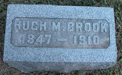
Hugh Marshall Brook
| Birth | : | 29 Dec 1847 Stronghurst, Henderson County, Illinois, USA |
| Death | : | 11 Nov 1910 Blue Mound, Linn County, Kansas, USA |
| Burial | : | Pleasant View Cemetery, Blue Mound, Linn County, USA |
| Coordinate | : | 38.0952988, -95.0175018 |
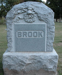
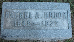
| Description | : | spouse of Rachel and father of Jamie. Brother of Thomas Brook. 1880 Blue Mound Twp, Linn County, KS Census. 1900 Blue Mound Twp, Linn County, KS Census. |
frequently asked questions (FAQ):
-
Where is Hugh Marshall Brook's memorial?
Hugh Marshall Brook's memorial is located at: Pleasant View Cemetery, Blue Mound, Linn County, USA.
-
When did Hugh Marshall Brook death?
Hugh Marshall Brook death on 11 Nov 1910 in Blue Mound, Linn County, Kansas, USA
-
Where are the coordinates of the Hugh Marshall Brook's memorial?
Latitude: 38.0952988
Longitude: -95.0175018
Family Members:
Flowers:


Nearby Cemetories:
1. Pleasant View Cemetery
Blue Mound, Linn County, USA
Coordinate: 38.0952988, -95.0175018
2. Sunny Slope Cemetery
Blue Mound, Linn County, USA
Coordinate: 38.0952988, -95.0149994
3. Old Blue Mound Cemetery
Blue Mound, Linn County, USA
Coordinate: 38.0636600, -95.0249000
4. Oakwood Cemetery
Centerville, Linn County, USA
Coordinate: 38.1605988, -95.0391998
5. Boulware Cemetery
Mapleton, Bourbon County, USA
Coordinate: 38.0264600, -95.0245400
6. African Cemetery
Mound City, Linn County, USA
Coordinate: 38.1388600, -94.9361000
7. Stevenson Cemetery
Mapleton, Bourbon County, USA
Coordinate: 38.0210991, -94.9847031
8. Osage Valley Cemetery
Mildred, Allen County, USA
Coordinate: 38.0313988, -95.0969009
9. Anderson Cemetery #1
Xenia, Bourbon County, USA
Coordinate: 37.9907700, -95.0025000
10. Campbell Cemetery
Blue Mound, Linn County, USA
Coordinate: 38.0735300, -94.8865600
11. Kincaid Cemetery
Kincaid, Anderson County, USA
Coordinate: 38.0917015, -95.1513977
12. Dingus-Wayne Cemetery
Linn County, USA
Coordinate: 38.1344500, -94.8892500
13. Colbert Cemetery
Mound City, Linn County, USA
Coordinate: 38.1094017, -94.8696976
14. Stanley Cemetery
Bayard, Allen County, USA
Coordinate: 37.9944200, -95.0970400
15. Fairview Cemetery
Mildred, Allen County, USA
Coordinate: 38.0238020, -95.1401740
16. Sugar Valley Cemetery
Anderson County, USA
Coordinate: 38.1903300, -95.1130200
17. Northway Cemetery
Mapleton, Bourbon County, USA
Coordinate: 37.9935989, -94.9321976
18. Curry Cemetery
Mound City, Linn County, USA
Coordinate: 38.1006012, -94.8608017
19. Centerville Cemetery
Centerville, Linn County, USA
Coordinate: 38.2191000, -94.9969000
20. Wesley Chapel Cemetery
Mound City, Linn County, USA
Coordinate: 38.1897800, -94.9072100
21. Mapleton Cemetery
Mapleton, Bourbon County, USA
Coordinate: 38.0227300, -94.8796500
22. Mount Zion Cemetery
Kincaid, Anderson County, USA
Coordinate: 38.1046982, -95.1864014
23. Park Cemetery
Mound City, Linn County, USA
Coordinate: 38.1383018, -94.8569031
24. Gillham Cemetery
Allen County, USA
Coordinate: 37.9795100, -95.1103500