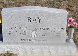
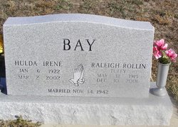
Hulda Irene Long Bay
| Birth | : | 6 Jan 1922 Arnold, Custer County, Nebraska, USA |
| Death | : | 2 Mar 2002 Broken Bow, Custer County, Nebraska, USA |
| Burial | : | McCain Cemetery, Gandy, Logan County, USA |
| Coordinate | : | 41.4219017, -100.4713974 |
| Description | : | H. Irene Bay, 80 Jan 6, 1922-March 2, 2002 STAPLETON - H. Irene Bay, 80, died Saturday, March 2, 2002, at Melham Medical Center at Broken Bow. She was born Jan. 6, 1922, at Arnold. Her parents were Fayette Solomon and Nancy Bell (Johnson) Long.She graduated from Arnold High School in 1940. She was married to Raleigh Rollin "Tuffy" Bay on Nov. 14, 1941, at North Platte. He preceded her in death. They farmed on the Garfield Table for 40 years and retired to North Platte. She was a member of the Presbyterian Church. She is survived by one daughter, Wilma Schaffert... Read More |
frequently asked questions (FAQ):
-
Where is Hulda Irene Long Bay's memorial?
Hulda Irene Long Bay's memorial is located at: McCain Cemetery, Gandy, Logan County, USA.
-
When did Hulda Irene Long Bay death?
Hulda Irene Long Bay death on 2 Mar 2002 in Broken Bow, Custer County, Nebraska, USA
-
Where are the coordinates of the Hulda Irene Long Bay's memorial?
Latitude: 41.4219017
Longitude: -100.4713974
Family Members:
Spouse
Flowers:
Nearby Cemetories:
1. McCain Cemetery
Gandy, Logan County, USA
Coordinate: 41.4219017, -100.4713974
2. Saint Johns Cemetery
Gandy, Logan County, USA
Coordinate: 41.4655991, -100.4828033
3. Garfield Cemetery
Lincoln County, USA
Coordinate: 41.3861008, -100.3878021
4. Myrtle Cemetery
Lincoln County, USA
Coordinate: 41.3443985, -100.5971985
5. Loup Valley Cemetery
Logan County, USA
Coordinate: 41.4700012, -100.6841965
6. Arnold Cemetery
Arnold, Custer County, USA
Coordinate: 41.4089012, -100.1903000
7. Kilmer Valley Cemetery
Lincoln County, USA
Coordinate: 41.3025017, -100.2347031
8. Powell Canyon Cemetery
Custer County, USA
Coordinate: 41.4543991, -100.1280975
9. Tallin Cemetery
Custer County, USA
Coordinate: 41.2625504, -100.1762543
10. Good Hope Cemetery
Lincoln County, USA
Coordinate: 41.2635994, -100.8114014
11. Svea Dal Cemetery
Lincoln County, USA
Coordinate: 41.1333008, -100.2778015
12. Antelope Cemetery
Lincoln County, USA
Coordinate: 41.1180992, -100.2936020
13. Miller Cemetery
Tryon, McPherson County, USA
Coordinate: 41.5892960, -100.8585770
14. Woldheim Cemetery
Custer County, USA
Coordinate: 41.3852997, -100.0246964
15. Lone Star Cemetery
McPherson County, USA
Coordinate: 41.7106000, -100.7129000
16. New Hope Church Cemetery
Custer County, USA
Coordinate: 41.1410141, -100.1987457
17. North Platte Cemetery
North Platte, Lincoln County, USA
Coordinate: 41.1481018, -100.7705994
18. McCullough Cemetery
Maxwell, Lincoln County, USA
Coordinate: 41.0694008, -100.5243988
19. Stop Table Cemetery
Custer County, USA
Coordinate: 41.2350006, -100.0642014
20. Episcopal Church of Our Savior Columbarium
North Platte, Lincoln County, USA
Coordinate: 41.1369000, -100.7650000
21. Sand Valley Cemetery
Callaway, Custer County, USA
Coordinate: 41.2775002, -100.0242004
22. Maranatha Bible Camp Cemetery
Maxwell, Lincoln County, USA
Coordinate: 41.0608400, -100.5617400
23. Schreyer Homestead Family Cemetery
Custer County, USA
Coordinate: 41.3330100, -99.9769800
24. Cliff Table Cemetery
Merna, Custer County, USA
Coordinate: 41.4694100, -99.9626800


