
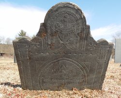
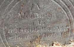
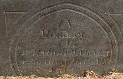
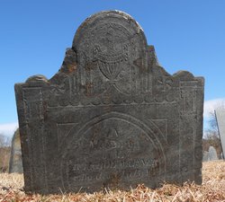
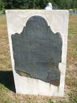
Ichabod Warner
| Birth | : | 1733 |
| Death | : | 13 Jul 1814 Bernardston, Franklin County, Massachusetts, USA |
| Burial | : | Old Cemetery, Bernardston, Franklin County, USA |
| Coordinate | : | 42.6810989, -72.5444031 |
| Description | : | _____________________________________________ He took an active part in the Indian warfare, being out in Israel Williams' Co., on duty to the westward from Dec. 11, 1755. to Oct. 18, 1756. His name appears on another muster roll of Capt. Williams', bearing dates from Oct. 19, 1756, to Jan. 23, 1757, on the same service. His name appears on two of John Burk's enlistment rolls, the first ending Nov. 30, 1758, the second organized Feb. 24, 1760, for the total reduction of Canada. He held various town offices, including that of selectman and surveyor of highways, and appears to have been one of the... Read More |
frequently asked questions (FAQ):
-
Where is Ichabod Warner's memorial?
Ichabod Warner's memorial is located at: Old Cemetery, Bernardston, Franklin County, USA.
-
When did Ichabod Warner death?
Ichabod Warner death on 13 Jul 1814 in Bernardston, Franklin County, Massachusetts, USA
-
Where are the coordinates of the Ichabod Warner's memorial?
Latitude: 42.6810989
Longitude: -72.5444031
Family Members:
Spouse
Children
Flowers:


Nearby Cemetories:
1. Center Cemetery
Bernardston, Franklin County, USA
Coordinate: 42.6695213, -72.5498505
2. Hessian Cemetery
Bernardston, Franklin County, USA
Coordinate: 42.6679174, -72.5897169
3. West Gill Cemetery
Gill, Franklin County, USA
Coordinate: 42.6442700, -72.5280500
4. Greenfield Hebrew Congregation Cemetery
Greenfield, Franklin County, USA
Coordinate: 42.6409410, -72.5653360
5. East Hill Cemetery
Leyden, Franklin County, USA
Coordinate: 42.6931000, -72.6025009
6. Mount Hermon Cemetery
Northfield, Franklin County, USA
Coordinate: 42.6790800, -72.4821100
7. Log Plain Cemetery
Greenfield, Franklin County, USA
Coordinate: 42.6378320, -72.5725800
8. Gill Center Cemetery
Gill, Franklin County, USA
Coordinate: 42.6413803, -72.4983063
9. North Cemetery
Gill, Franklin County, USA
Coordinate: 42.6514160, -72.4817630
10. Center Cemetery
Northfield, Franklin County, USA
Coordinate: 42.6954308, -72.4613342
11. West Northfield Cemetery
Northfield, Franklin County, USA
Coordinate: 42.7117004, -72.4689026
12. Tyler Cemetery
Vernon, Windham County, USA
Coordinate: 42.7344017, -72.4972000
13. South Leyden Cemetery
Leyden, Franklin County, USA
Coordinate: 42.6831400, -72.6311200
14. Riverside Cemetery
Gill, Franklin County, USA
Coordinate: 42.6156006, -72.5410995
15. Beaver Meadow Cemetery
Leyden, Franklin County, USA
Coordinate: 42.7188988, -72.6183014
16. Country Farms Cemetery
Greenfield, Franklin County, USA
Coordinate: 42.6393900, -72.6165400
17. Pentecost Cemetery
Northfield, Franklin County, USA
Coordinate: 42.7010200, -72.4539900
18. Beers Ambush Gravesite
Northfield, Franklin County, USA
Coordinate: 42.6501200, -72.4560300
19. Saint Marys Cemetery
Northfield, Franklin County, USA
Coordinate: 42.6868910, -72.4448190
20. South Vernon Cemetery
South Vernon, Windham County, USA
Coordinate: 42.7341400, -72.4691700
21. Baker Cemetery
Guilford, Windham County, USA
Coordinate: 42.7378006, -72.6160965
22. Round Top Cemetery
Northfield, Franklin County, USA
Coordinate: 42.7120600, -72.4447300
23. High Street Cemetery
Greenfield, Franklin County, USA
Coordinate: 42.6044840, -72.5806660
24. Maplehurst Cemetery
Guilford, Windham County, USA
Coordinate: 42.7618450, -72.5685760