
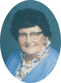

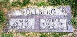
Iona Mable Bisson Wollberg
| Birth | : | 19 Mar 1911 Platte County, Nebraska, USA |
| Death | : | 29 Sep 2005 Columbus, Platte County, Nebraska, USA |
| Burial | : | Highland Cemetery, Adams, Gage County, USA |
| Coordinate | : | 40.4580994, -96.5196991 |
| Description | : | Daughter of C.J. & Alma (Lueschen) Bisson. Iona attended District 77 school in Platte County. On October 4, 1931, Iona married Louis Wollberg in Leigh, Nebraska. They lived north of Columbus for many years. Iona worked as a clerk at the TGY and Scotts stores in Columbus for 21 years. She also helped her husband with his garbage business and enjoyed working outside. She was a member of Immanuel Lutheran Church where she was active in the LWML, the choir, the Mission Society, and was also a Sunday School Teacher. Iona enjoyed playing shuffleboard and was an avid Nebraska football fan. Iona... Read More |
frequently asked questions (FAQ):
-
Where is Iona Mable Bisson Wollberg's memorial?
Iona Mable Bisson Wollberg's memorial is located at: Highland Cemetery, Adams, Gage County, USA.
-
When did Iona Mable Bisson Wollberg death?
Iona Mable Bisson Wollberg death on 29 Sep 2005 in Columbus, Platte County, Nebraska, USA
-
Where are the coordinates of the Iona Mable Bisson Wollberg's memorial?
Latitude: 40.4580994
Longitude: -96.5196991
Family Members:
Parent
Spouse
Siblings

Children

Flowers:


Nearby Cemetories:
1. Highland Cemetery
Adams, Gage County, USA
Coordinate: 40.4580994, -96.5196991
2. Hooker Cemetery
Adams, Gage County, USA
Coordinate: 40.4207993, -96.4732971
3. Grandview Cemetery
Gage County, USA
Coordinate: 40.4617004, -96.6091995
4. Granite Hill Cemetery
Johnson County, USA
Coordinate: 40.4180984, -96.4417038
5. Immanuel Cemetery
Sterling, Johnson County, USA
Coordinate: 40.4692001, -96.4253006
6. Latrobe Cemetery
Sterling, Johnson County, USA
Coordinate: 40.5151000, -96.4557000
7. Weber Cemetery
Sterling, Johnson County, USA
Coordinate: 40.4581000, -96.4177000
8. Saint Johns Lutheran Cemetery
Cortland, Gage County, USA
Coordinate: 40.5078300, -96.6252700
9. Firth Cemetery
Firth, Lancaster County, USA
Coordinate: 40.5250015, -96.6085968
10. Pella Cemetery
Panama, Lancaster County, USA
Coordinate: 40.5555992, -96.5014038
11. Saint John North Lutheran Cemetery
Sterling, Johnson County, USA
Coordinate: 40.4689500, -96.3878500
12. Sunnyside Cemetery
Cortland, Gage County, USA
Coordinate: 40.4799200, -96.6511800
13. South Saint John Lutheran Cemetery
Sterling, Johnson County, USA
Coordinate: 40.4355500, -96.3858000
14. Dietz Cemetery
Firth, Lancaster County, USA
Coordinate: 40.5449982, -96.6286011
15. Sterling Cemetery
Sterling, Johnson County, USA
Coordinate: 40.4585991, -96.3582993
16. Panama Cemetery
Panama, Lancaster County, USA
Coordinate: 40.5821991, -96.5255966
17. Zion Evangelical Lutheran Cemetery
Pickrell, Gage County, USA
Coordinate: 40.3456001, -96.6147003
18. Christ Lutheran Church Cemetery
Pickrell, Gage County, USA
Coordinate: 40.4079410, -96.6848370
19. Saint James Cemetery
Cortland, Gage County, USA
Coordinate: 40.4886050, -96.7036050
20. Cortland Cemetery
Cortland, Gage County, USA
Coordinate: 40.4879200, -96.7041250
21. Crab Orchard Cemetery
Crab Orchard, Johnson County, USA
Coordinate: 40.3274994, -96.4366989
22. Solon Cemetery
Otoe County, USA
Coordinate: 40.5917015, -96.4436035
23. Holland Cemetery
Holland, Lancaster County, USA
Coordinate: 40.5957985, -96.5997009
24. Rosehill Cemetery
Douglas, Otoe County, USA
Coordinate: 40.5845940, -96.3867900