
| Birth | : | 2 Dec 1923 Melcher-Dallas, Marion County, Iowa, USA |
| Death | : | 6 May 2009 Maryville, Nodaway County, Missouri, USA |
| Burial | : | Gulwarra Heights Cemetery, Warragul, Baw Baw Shire, Australia |
| Coordinate | : | -38.1517400, 145.8971990 |
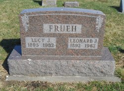
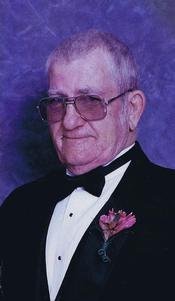
| Description | : | Irene Mildred Meyer, 85, Maryville, Mo. died Wednesday, May 6, 2009 at Nodaway Nursing Home, Maryville. She was born December 2, 1923 in Melcher, Iowa, the daughter of Leonard and Lucy Walk Frueh. A 1941 graduate of Maryville High School, Irene marred Gerald "Jerry" Meyer May 8, 1948 in Maryville. She and Jerry owned and operated "Meyer's Specialty Store" in Maryville for many years. Irene was a member of St. Gregory Barbarigo Catholic Community and St. Gregory's Guild, Maryville. She like to play bridge and belonged to several bridge clubs in the past. She... Read More |
frequently asked questions (FAQ):
-
Where is Irene Mildred Frueh Meyer's memorial?
Irene Mildred Frueh Meyer's memorial is located at: Gulwarra Heights Cemetery, Warragul, Baw Baw Shire, Australia.
-
When did Irene Mildred Frueh Meyer death?
Irene Mildred Frueh Meyer death on 6 May 2009 in Maryville, Nodaway County, Missouri, USA
-
Where are the coordinates of the Irene Mildred Frueh Meyer's memorial?
Latitude: -38.1517400
Longitude: 145.8971990
Family Members:
Parent

Siblings

Flowers:


Nearby Cemetories:
1. Gulwarra Heights Cemetery
Warragul, Baw Baw Shire, Australia
Coordinate: -38.1517400, 145.8971990
2. Warragul Cemetery
Warragul, Baw Baw Shire, Australia
Coordinate: -38.1528830, 145.9333490
3. Drouin Cemetery
Drouin, Baw Baw Shire, Australia
Coordinate: -38.1230656, 145.8318535
4. Drouin West Cemetery
Drouin West, Baw Baw Shire, Australia
Coordinate: -38.0923773, 145.8431423
5. Ripplebrook Cemetery
Drouin South, Baw Baw Shire, Australia
Coordinate: -38.2074990, 145.7508310
6. Yarragon Cemetery
Yarragon, Baw Baw Shire, Australia
Coordinate: -38.2013220, 146.0547570
7. Bunyip Cemetery
Bunyip, Cardinia Shire, Australia
Coordinate: -38.0838160, 145.7169040
8. Neerim Cemetery
Neerim, Baw Baw Shire, Australia
Coordinate: -37.9573912, 145.9553572
9. Saint Mary's Anglican Church
Trafalgar, Baw Baw Shire, Australia
Coordinate: -38.2112176, 146.1548115
10. Poowong Cemetery
Poowong, South Gippsland Shire, Australia
Coordinate: -38.3461002, 145.7615830
11. Willow Grove Cemetery
Willow Grove, Baw Baw Shire, Australia
Coordinate: -38.0694800, 146.1750300
12. Trafalgar Cemetery
Trafalgar, Baw Baw Shire, Australia
Coordinate: -38.1998610, 146.1964090
13. Childers and Thorpdale Cemetery
Thorpdale, Baw Baw Shire, Australia
Coordinate: -38.3060020, 146.1422990
14. Allambee East Cemetery
Allambee South, South Gippsland Shire, Australia
Coordinate: -38.3594710, 146.0860860
15. Maryknoll Cemetery
Maryknoll, Cardinia Shire, Australia
Coordinate: -38.0279016, 145.6027254
16. Nyora Cemetery
Nyora, South Gippsland Shire, Australia
Coordinate: -38.3406970, 145.6637270
17. Lang Lang Cemetery
Lang Lang, Cardinia Shire, Australia
Coordinate: -38.2779980, 145.5831970
18. Korumburra Cemetery
Korumburra, South Gippsland Shire, Australia
Coordinate: -38.4303000, 145.8482100
19. Moe Cemetery
Moe, Latrobe City, Australia
Coordinate: -38.1857360, 146.2685000
20. Coal Creek Community Park and Museum
Korumburra, South Gippsland Shire, Australia
Coordinate: -38.4438019, 145.8312988
21. Narracan
Narracan East, Baw Baw Shire, Australia
Coordinate: -38.2797411, 146.2459113
22. Beenak Cemetery
Beenak, Yarra Ranges Shire, Australia
Coordinate: -37.8894180, 145.6445400
23. Yallourn Cemetery
Yallourn, Latrobe City, Australia
Coordinate: -38.2003610, 146.3114980
24. Mirboo North Cemetery
South Gippsland Shire, Australia
Coordinate: -38.4030220, 146.1725580