

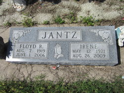
Irene Schmidt Jantz
| Birth | : | 12 May 1921 Moundridge, McPherson County, Kansas, USA |
| Death | : | 26 Aug 2009 La Harpe, Allen County, Kansas, USA |
| Burial | : | Hampden Cemetery, Hampden, Waitaki District, New Zealand |
| Coordinate | : | -45.3222500, 170.8244100 |
| Description | : | *************************** Published Aug. 27, 2009 - Iola, KS Irene Jantz, 88, of LaHarpe, Kansas, died Wednesday, August 26, 2009, at her home. Irene was born May 12, 1921 in Moundridge, Kansas the daughter of Jacob T. and Katie (Wedel) Schmidt. She grew up in Western Kansas. On July 28, 1941, Irene married Floyd R. Jantz. He preceded her in death on June 1, 2006. They lived and farmed near Syracuse, Kansas until moving to a farm south of Gas City in 1951. They operated a dairy and did custom combine cutting. They left the farm and moved into Gas City, Kansas. Survivors include two... Read More |
frequently asked questions (FAQ):
-
Where is Irene Schmidt Jantz's memorial?
Irene Schmidt Jantz's memorial is located at: Hampden Cemetery, Hampden, Waitaki District, New Zealand.
-
When did Irene Schmidt Jantz death?
Irene Schmidt Jantz death on 26 Aug 2009 in La Harpe, Allen County, Kansas, USA
-
Where are the coordinates of the Irene Schmidt Jantz's memorial?
Latitude: -45.3222500
Longitude: 170.8244100
Family Members:
Parent
Spouse
Siblings

Children

Flowers:


Nearby Cemetories:
1. Hampden Cemetery
Hampden, Waitaki District, New Zealand
Coordinate: -45.3222500, 170.8244100
2. Hampstead Family Cemetery
Moeraki, Waitaki District, New Zealand
Coordinate: -45.3659800, 170.8603650
3. Moeraki Urupā
Moeraki, Waitaki District, New Zealand
Coordinate: -45.3703480, 170.8639030
4. Otepopo Cemetery
Herbert, Waitaki District, New Zealand
Coordinate: -45.2330200, 170.7877970
5. Maheno Cemetery
Maheno, Waitaki District, New Zealand
Coordinate: -45.1788100, 170.8483800
6. Palmerston Cemetery
Palmerston, Waitaki District, New Zealand
Coordinate: -45.4933100, 170.7011100
7. Goodwood Cemetery
Goodwood, Waitaki District, New Zealand
Coordinate: -45.5288710, 170.7465800
8. Oamaru Lawn Cemetery
Oamaru, Waitaki District, New Zealand
Coordinate: -45.1095700, 170.9569500
9. Oamaru Old Cemetery
Oamaru, Waitaki District, New Zealand
Coordinate: -45.1084060, 170.9599220
10. Westview Memorial Gardens
Oamaru, Waitaki District, New Zealand
Coordinate: -45.0959160, 170.9313660
11. Macraes Flat Old Cemetery
Palmerston, Waitaki District, New Zealand
Coordinate: -45.3797330, 170.4321020
12. Hawksbury Cemetery
Waikouaiti, Dunedin City, New Zealand
Coordinate: -45.5885900, 170.6910900
13. Macraes Flat New Cemetery
Macraes Flat, Waitaki District, New Zealand
Coordinate: -45.3874190, 170.4176450
14. St. John's Anglican Cemetery
Waikouaiti, Dunedin City, New Zealand
Coordinate: -45.6061000, 170.6700700
15. Karitane Cemetery
Karitane, Dunedin City, New Zealand
Coordinate: -45.6423740, 170.6596370
16. Papakaio Cemetery
Papakaio, Waitaki District, New Zealand
Coordinate: -44.9876130, 170.9546710
17. Puketeraki Cemetery
Puketeraki, Dunedin City, New Zealand
Coordinate: -45.6514260, 170.6480880
18. Brinns Point Cemetery
Seacliff, Dunedin City, New Zealand
Coordinate: -45.6711100, 170.6512700
19. Ngapara Cemetery
Ngapara, Waitaki District, New Zealand
Coordinate: -44.9403020, 170.7573980
20. Hyde Cemetery
Hyde, Dunedin City, New Zealand
Coordinate: -45.2986410, 170.2748670
21. Merton Cemetery
Seacliff, Dunedin City, New Zealand
Coordinate: -45.6685430, 170.5745520
22. Livingstone Cemetery
Livingstone, Waitaki District, New Zealand
Coordinate: -44.9566590, 170.5708160
23. Georgetown Cemetery
Georgetown, Waitaki District, New Zealand
Coordinate: -44.9127820, 170.8442780
24. St. Barnabas Churchyard
Warrington, Dunedin City, New Zealand
Coordinate: -45.7060550, 170.5946900