
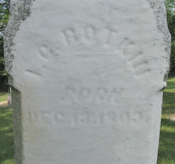
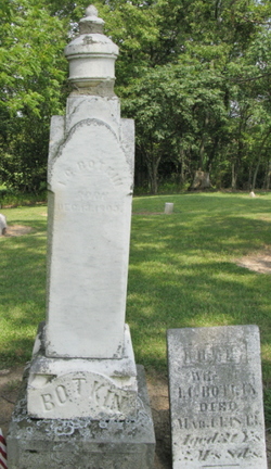
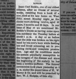
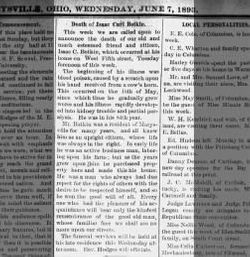
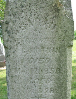
Isaac Curl Botkin
| Birth | : | 13 Dec 1809 Clark County, Ohio, USA |
| Death | : | 6 Jun 1893 Marysville, Union County, Ohio, USA |
| Burial | : | Cranbrook Old General Cemetery, Cranbrook, East Kootenay Regional District, Canada |
| Coordinate | : | 49.5116630, -115.7826420 |
| Description | : | Isaac Curl Botkin married (1) Ruth Dean about 1833, married (2) Sarah Dalrymple 30 Aug 1843 in Clark Co., OH, and (3) Susan Jane Robb 21 Jan 1851 in Clark Co., OH. __________ Note: There is also another memorial for Issac Curl Botkin at Oakdale Cemetery, Marysville, Ohio billiongraves.com/pages/record/IsaacCurlBotkin/4390180 |
frequently asked questions (FAQ):
-
Where is Isaac Curl Botkin's memorial?
Isaac Curl Botkin's memorial is located at: Cranbrook Old General Cemetery, Cranbrook, East Kootenay Regional District, Canada.
-
When did Isaac Curl Botkin death?
Isaac Curl Botkin death on 6 Jun 1893 in Marysville, Union County, Ohio, USA
-
Where are the coordinates of the Isaac Curl Botkin's memorial?
Latitude: 49.5116630
Longitude: -115.7826420
Family Members:
Parent

Spouse
Siblings
Children
Flowers:


Nearby Cemetories:
1. Cranbrook Old General Cemetery
Cranbrook, East Kootenay Regional District, Canada
Coordinate: 49.5116630, -115.7826420
2. Westlawn Cemetery
Cranbrook, East Kootenay Regional District, Canada
Coordinate: 49.5112220, -115.7821910
3. Cranbrook New General Cemetery
Cranbrook, East Kootenay Regional District, Canada
Coordinate: 49.5118890, -115.7837250
4. Cranbrook Catholic Cemetery
Cranbrook, East Kootenay Regional District, Canada
Coordinate: 49.5114080, -115.7813930
5. Aqam Cemetery
Cranbrook, East Kootenay Regional District, Canada
Coordinate: 49.5833840, -115.7574800
6. Fort Steele Cemetery
Fort Steele, East Kootenay Regional District, Canada
Coordinate: 49.6260109, -115.6225662
7. Marysville Cemetery
Marysville, East Kootenay Regional District, Canada
Coordinate: 49.6386900, -115.9513300
8. Kimberley Cemetery
Kimberley, East Kootenay Regional District, Canada
Coordinate: 49.6766700, -115.9746000
9. Moyie Cemetery
Moyie, East Kootenay Regional District, Canada
Coordinate: 49.2743920, -115.8350350
10. Sand Creek Cemetery
Jaffray, East Kootenay Regional District, Canada
Coordinate: 49.3362250, -115.2909390
11. Baynes Lake Cemetery
Baynes Lake, East Kootenay Regional District, Canada
Coordinate: 49.2369900, -115.2106000
12. Yahk Cemetery
Yahk, Central Kootenay Regional District, Canada
Coordinate: 49.0885510, -116.0776230
13. Fernie Cemetery
Fernie, East Kootenay Regional District, Canada
Coordinate: 49.5002240, -115.0579050
14. East Fernie Cemetery
Fernie, East Kootenay Regional District, Canada
Coordinate: 49.5018590, -115.0566640
15. Elko Cemetery
Elko, East Kootenay Regional District, Canada
Coordinate: 49.2978200, -115.1353500
16. Saint Margaret's Cemetery
Fernie, East Kootenay Regional District, Canada
Coordinate: 49.4989900, -115.0550900
17. Morrissey Cemetery
Morrissey, East Kootenay Regional District, Canada
Coordinate: 49.3751030, -114.9941990
18. Hannah Robinson Gravesite
Morrissey, East Kootenay Regional District, Canada
Coordinate: 49.3725000, -114.9913800
19. Hosmer Cemetery
Hosmer, East Kootenay Regional District, Canada
Coordinate: 49.5863580, -114.9565980
20. Goat River Cemetery
Creston, Central Kootenay Regional District, Canada
Coordinate: 49.1411200, -116.3992060
21. Boyd Cemetery
Libby, Lincoln County, USA
Coordinate: 48.9543991, -115.6046982
22. Forest Lawn Cemetery
Creston, Central Kootenay Regional District, Canada
Coordinate: 49.0991400, -116.4626400
23. Rivercrest Cemetery
Sparwood, East Kootenay Regional District, Canada
Coordinate: 49.7617300, -114.8862200
24. Pioneer Cemetery
Creston, Central Kootenay Regional District, Canada
Coordinate: 49.0921800, -116.5127700