Isaac L. Marlowe Sr.
| Birth | : | 1838 |
| Death | : | unknown |
| Burial | : | St John The Baptist Churchyard, Nettleton, West Lindsey District, England |
| Coordinate | : | 53.4867340, -0.3269800 |
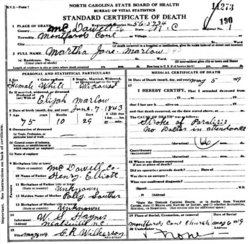
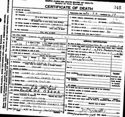
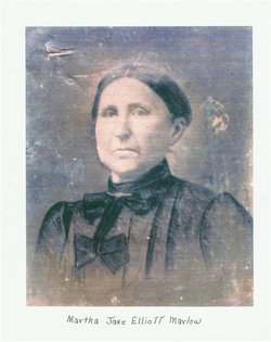
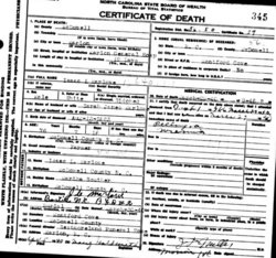
| Description | : | Isaac L.(?)(Elijah?) Marlowe/Marlow (Wife's D.C. has Elijah Marlow) b. about 1838 (est.) Spouse of Martha Jane Souther (or Elliott?) Marlowe/Marlow, b. 1843, McDowell Co., N.C., (daughter of Henry Elliott, b. McDowell Co., N.C. & Polly Souther, b. Ukn.) See * Death Certificate (top) Father of Isaac L. Marlowe/Marlow, b. 1863, McDowell Co., N.C. (Isaac L. Marlowe/Marlow, Jr.'s Death Certificate states his Father was Isaac L. Marlowe and his Mother was Martha Souther Marlowe.) See * Death Certificate (bottom) |
frequently asked questions (FAQ):
-
Where is Isaac L. Marlowe Sr.'s memorial?
Isaac L. Marlowe Sr.'s memorial is located at: St John The Baptist Churchyard, Nettleton, West Lindsey District, England.
-
When did Isaac L. Marlowe Sr. death?
Isaac L. Marlowe Sr. death on unknown in
-
Where are the coordinates of the Isaac L. Marlowe Sr.'s memorial?
Latitude: 53.4867340
Longitude: -0.3269800
Family Members:
Spouse
Children
Flowers:

Left by Anonymous on 04 Jun 2010

Left by Anonymous on 07 Nov 2012
This person does not exist. Autumn believed this was the father of Isaac Elijah Marlow, Sr., whose actual name was Elijah Washington Marlow, already listed. She was not to be deterred. Confused enough? Just wait until you see that some have an "e" and some do not--in the same family! Read less
Left by Anonymous on 21 Aug 2015
Nearby Cemetories:
1. St John The Baptist Churchyard
Nettleton, West Lindsey District, England
Coordinate: 53.4867340, -0.3269800
2. Caistor Cemetery
Caistor, West Lindsey District, England
Coordinate: 53.4968870, -0.3299210
3. St. Peter and St. Paul Churchyard
Caistor, West Lindsey District, England
Coordinate: 53.4963400, -0.3179900
4. Caistor Congregational Chapelyard
Caistor, West Lindsey District, England
Coordinate: 53.4971540, -0.3181850
5. St Nicholas Churchyard
Cabourne, West Lindsey District, England
Coordinate: 53.5015800, -0.2830600
6. St Mary Magdalene Churchyard
Rothwell, West Lindsey District, England
Coordinate: 53.4783820, -0.2693190
7. All Hallows Churchyard
Clixby, West Lindsey District, England
Coordinate: 53.5233610, -0.3384560
8. Grasby Church Burial Ground
Grasby, West Lindsey District, England
Coordinate: 53.5285230, -0.3598880
9. All Saints Churchyard
Grasby, West Lindsey District, England
Coordinate: 53.5295671, -0.3610532
10. St. Mary's Churchyard
Claxby, West Lindsey District, England
Coordinate: 53.4363000, -0.3287600
11. St Nicholas Church
Cuxwold, West Lindsey District, England
Coordinate: 53.4936120, -0.2347580
12. North Kelsey Cemetery
North Kelsey, West Lindsey District, England
Coordinate: 53.5043330, -0.4245830
13. Saint Nicholas and All Hallows Churc
North Kelsey, West Lindsey District, England
Coordinate: 53.5002181, -0.4266914
14. St Nicholas Churchyard
Searby, West Lindsey District, England
Coordinate: 53.5384960, -0.3830950
15. St Nicholas Church
South Kelsey, West Lindsey District, England
Coordinate: 53.4756720, -0.4297440
16. South Kelsey Brigg Road Cemetery
South Kelsey, West Lindsey District, England
Coordinate: 53.4755480, -0.4297340
17. St. Mary's Churchyard
South Kelsey, West Lindsey District, England
Coordinate: 53.4704260, -0.4321350
18. St. Martin Churchyard
North Owersby, West Lindsey District, England
Coordinate: 53.4387500, -0.4029500
19. St Margaret Churchyard
Somerby, West Lindsey District, England
Coordinate: 53.5455030, -0.3982090
20. St. Andrew's Churchyard
Stainton-le-Vale, West Lindsey District, England
Coordinate: 53.4333900, -0.2309600
21. Kirkby cum Osgodby Cemetery
Kirkby cum Osgodby, West Lindsey District, England
Coordinate: 53.4202700, -0.3977200
22. St Peter
Great Limber, West Lindsey District, England
Coordinate: 53.5619890, -0.2879080
23. Saint Peter's churchyard
Great Limber, West Lindsey District, England
Coordinate: 53.5620200, -0.2878700
24. St Andrew Churchyard
Kirkby cum Osgodby, West Lindsey District, England
Coordinate: 53.4210980, -0.4015720


