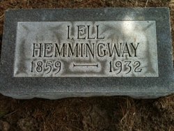
Israel Eleazer “Ell” Hemmingway
| Birth | : | 27 Jan 1859 Johnson County, Iowa, USA |
| Death | : | 14 Nov 1932 Oklahoma City, Oklahoma County, Oklahoma, USA |
| Burial | : | Springdale Cemetery, Springdale, Cedar County, USA |
| Coordinate | : | 41.6786003, -91.2581024 |
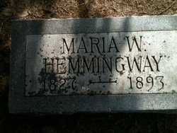
| Description | : | Israel Eleazer Hemmingway was the youngest child of five children born to Eleazer D. Hemmingway and Maria Whitacre Negus. He was not married at the time of his death and did not have any children. He had been living in Oklahoma City for 25 years and his occupation was in the real estate and loan brokerage business. He had gone to the home farm of a couple to discuss payment on their mortgage or foreclosure of their farm on November 13, 1932 and his body was found the following day on the couple's farm. The couple was held... Read More |
frequently asked questions (FAQ):
-
Where is Israel Eleazer “Ell” Hemmingway's memorial?
Israel Eleazer “Ell” Hemmingway's memorial is located at: Springdale Cemetery, Springdale, Cedar County, USA.
-
When did Israel Eleazer “Ell” Hemmingway death?
Israel Eleazer “Ell” Hemmingway death on 14 Nov 1932 in Oklahoma City, Oklahoma County, Oklahoma, USA
-
Where are the coordinates of the Israel Eleazer “Ell” Hemmingway's memorial?
Latitude: 41.6786003
Longitude: -91.2581024
Family Members:
Parent
Siblings
Flowers:
Nearby Cemetories:
1. Springdale Cemetery
Springdale, Cedar County, USA
Coordinate: 41.6786003, -91.2581024
2. North Liberty Cemetery
Springdale, Cedar County, USA
Coordinate: 41.6852989, -91.2292023
3. Pee Dee Cemetery
Cedar County, USA
Coordinate: 41.6699982, -91.2142029
4. Hickory Grove Cemetery
Cedar County, USA
Coordinate: 41.6637000, -91.3073000
5. Chamness Burial Plot
Springdale, Cedar County, USA
Coordinate: 41.6597351, -91.3182108
6. Saint Joseph Cemetery
Cedar Valley, Cedar County, USA
Coordinate: 41.7295000, -91.2667000
7. Burnett Burial Site
Rochester, Cedar County, USA
Coordinate: 41.6680782, -91.1834911
8. Saint Bernadette Catholic Church
West Branch, Cedar County, USA
Coordinate: 41.6755750, -91.3396070
9. Honey Grove Cemetery
Cedar County, USA
Coordinate: 41.7158012, -91.3266983
10. Friends Village Cemetery
West Branch, Cedar County, USA
Coordinate: 41.6732000, -91.3470000
11. West Branch Cemetery
West Branch, Cedar County, USA
Coordinate: 41.6765000, -91.3515000
12. Herbert Hoover National Historic Site
West Branch, Cedar County, USA
Coordinate: 41.6681500, -91.3519900
13. Howard Cemetery
Plato, Cedar County, USA
Coordinate: 41.7486303, -91.2918299
14. Dunfee Burial Site
Rochester, Cedar County, USA
Coordinate: 41.6266900, -91.1834904
15. Downey Cemetery
Downey, Cedar County, USA
Coordinate: 41.6119003, -91.3182983
16. Mount Zion Church Cemetery
Cedar County, USA
Coordinate: 41.7343000, -91.1790000
17. West Bethel Cemetery
Cedar County, USA
Coordinate: 41.6502991, -91.1556015
18. United Brethren Cemetery
Cedar County, USA
Coordinate: 41.7445000, -91.3285000
19. North Prairie Cemetery
West Liberty, Muscatine County, USA
Coordinate: 41.5924988, -91.2694016
20. Goodale Cemetery
Tipton, Cedar County, USA
Coordinate: 41.7219380, -91.1567400
21. Woodbridge Cemetery
Buchanan, Cedar County, USA
Coordinate: 41.7644005, -91.2294006
22. Rochester Cemetery
Rochester, Cedar County, USA
Coordinate: 41.6656200, -91.1395800
23. Kizer-Burns Cemetery
Tipton, Cedar County, USA
Coordinate: 41.7559130, -91.1854800
24. Oasis Cemetery
Oasis, Johnson County, USA
Coordinate: 41.7005997, -91.3858032


