
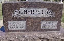
James A Harper
| Birth | : | 7 Dec 1855 |
| Death | : | 8 Mar 1941 |
| Burial | : | St. Nicholas' Churchyard, Blakeney, North Norfolk District, England |
| Coordinate | : | 52.9512300, 1.0247250 |
frequently asked questions (FAQ):
-
Where is James A Harper's memorial?
James A Harper's memorial is located at: St. Nicholas' Churchyard, Blakeney, North Norfolk District, England.
-
When did James A Harper death?
James A Harper death on 8 Mar 1941 in
-
Where are the coordinates of the James A Harper's memorial?
Latitude: 52.9512300
Longitude: 1.0247250
Family Members:
Parent
Spouse
Siblings
Children
Flowers:


Nearby Cemetories:
1. St. Nicholas' Churchyard
Blakeney, North Norfolk District, England
Coordinate: 52.9512300, 1.0247250
2. Carmelite Friary of the Blessed Virgin
Blakeney, North Norfolk District, England
Coordinate: 52.9553240, 1.0234250
3. St Margaret Churchyard
Cley, North Norfolk District, England
Coordinate: 52.9463890, 1.0475480
4. All Saints Churchyard
Morston, North Norfolk District, England
Coordinate: 52.9543600, 0.9886660
5. St. Martin's Churchyard, Glandford
Letheringsett, North Norfolk District, England
Coordinate: 52.9311970, 1.0396308
6. St Andrew and St Mary Churchyard
Langham, North Norfolk District, England
Coordinate: 52.9310020, 0.9855430
7. St. Margaret's Churchyard
Saxlingham, North Norfolk District, England
Coordinate: 52.9155250, 1.0121410
8. St Nicholas Churchyard
Salthouse, North Norfolk District, England
Coordinate: 52.9503200, 1.0889800
9. Saint Andrew's Churchyard
Field Dalling, North Norfolk District, England
Coordinate: 52.9110600, 0.9832800
10. All Saints Churchyard
Cockthorpe, North Norfolk District, England
Coordinate: 52.9407830, 0.9472385
11. St. Andrews Churchyard
Letheringsett, North Norfolk District, England
Coordinate: 52.9081600, 1.0623490
12. St. Mary the Virgin Churchyard
Kelling, North Norfolk District, England
Coordinate: 52.9322300, 1.1053700
13. Holt Town Cemetery
Holt, North Norfolk District, England
Coordinate: 52.9117900, 1.0850400
14. Binham Priory
Binham, North Norfolk District, England
Coordinate: 52.9199700, 0.9452300
15. Methodist Memorial Gardens
Holt, North Norfolk District, England
Coordinate: 52.9067730, 1.0878360
16. Saint Andrew the Apostle
Holt, North Norfolk District, England
Coordinate: 52.9063400, 1.0933500
17. All Saints Churchyard
Bale, North Norfolk District, England
Coordinate: 52.8906290, 0.9871950
18. St. Andrew's Churchyard
Brinton, North Norfolk District, England
Coordinate: 52.8803690, 1.0274610
19. St Mary Churchyard
Gunthorpe, North Norfolk District, England
Coordinate: 52.8767720, 0.9883020
20. St. Martin's Churchyard
Hindringham, North Norfolk District, England
Coordinate: 52.8882000, 0.9477300
21. St Lawrence Churchyard
Hunworth, North Norfolk District, England
Coordinate: 52.8772530, 1.0673080
22. St Maurice Churchyard
Briningham, North Norfolk District, England
Coordinate: 52.8682680, 1.0271340
23. St Andrew Churchyard
Hempstead, North Norfolk District, England
Coordinate: 52.8895750, 1.1270070
24. All Saints Churchyard
Hempstead, North Norfolk District, England
Coordinate: 52.8895200, 1.1274620